 W
WBeyond Capricorn: How Portuguese adventurers secretly discovered and mapped Australia and New Zealand 250 years before Captain Cook is a 2007 book by journalist Peter Trickett on the theory of Portuguese discovery of Australia. Although its thesis is similar to that advanced by Kenneth McIntyre in 1977, Lawrence Fitzgerald in 1984 and others, the publisher and some news reports presented it as being a new theory on the discovery of Australia.
 W
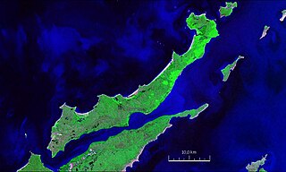
WCarronade Island lies off the northern (Kimberley) coast of Western Australia, in Napier Broome Bay. It owes its name to two swivel guns found there in 1916, mistakenly described at the time as carronades.
 W
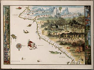
WThe Dieppe maps are a series of world maps produced in Dieppe, France, in the 1540s, 1550s, and 1560s. They are large hand-produced maps, commissioned for wealthy and royal patrons, including Henry II of France and Henry VIII of England. The Dieppe school of cartographers included Pierre Desceliers, Jean Rotz, Guillaume Le Testu, Guillaume Brouscon and Nicolas Desliens.
 W
WElcho Island, known to its traditional owners as Galiwin'ku (Galiwinku) is an island off the coast of Arnhem Land, in the Northern Territory of Australia. It is located at the southern end of the Wessel Islands group located in the East Arnhem Region. Galiwin'ku is also the name of the settlement where the island's largest community lives. Elcho Island formed part of the traditional lands of the Yan-nhaŋu, according to Norman Tindale. According to J. C. Jennison, the Aboriginal inhabitants were the Dhuwal, who called themselves the Kokalango Mala (mala=clan.)
 W
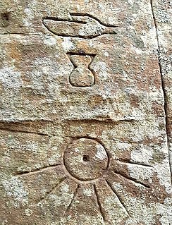
WThe Gosford Glyphs are a group of approximately 300 pseudo-Egyptian hieroglyphs located in Kariong, New South Wales, Australia. They are found in an area known for its Aboriginal petroglyphs, just between Gosford and Woy Woy, within the Brisbane Water National Park. The glyphs have been since dismissed as a hoax by authorities and academics after their discovery in the 1970s, but there are still attempts to prove the belief that they were carved by the ancient Egyptians about 4,500 years ago.
 W
WThe Javanese presence in Australia has been reported by native Southeast Asian and European people over several centuries. The most renowned record is from the itinerary of Chiaymasiouro, king of Demak, and Declaraçam de Malaca e India Meridional com o Cathay by Manuel Godinho de Eredia. Chiaymasiouro describes a land called Luca Antara in Southeast direction of Java, which Eredia coined the term India Meridional. According to Chiaymasiouro's accounts, a subgroup of Javanese people already settled in those lands, but when Eredia's servant went to Luca Antara in 1610, the land had seemingly been abandoned.
 W
WLa grande isle de Java was, according to Marco Polo, the largest island in the world; his Java Minor was the actual island of Sumatra, which takes its name from the city of Samudera situated on its northern coast.
 W
WThe Austronesian Makassar people from the region of Sulawesi began visiting the coast of northern Australia sometime around the early to middle 1700s, first in the Kimberley region, and some decades later in Arnhem Land.
 W
WThe theory of Portuguese discovery of Australia claims that early Portuguese navigators were the first Europeans to sight Australia between 1521 and 1524, well before the arrival of Dutch navigator Willem Janszoon in 1606 on board the Duyfken who is generally considered to be the first European discoverer. This is based on the following elements:The Dieppe maps, a group of 16th-century French world maps, which depict a large landmass between Indonesia and Antarctica. Labelled as Java la Grande, this land mass carries French, Portuguese, and Gallicized Portuguese placenames, and has been interpreted by some as corresponding to Australia's northwestern and eastern coasts. The presence of Portuguese colonies in Southeast Asia from the early 16th century, particularly Portuguese Timor – approximately 650 kilometres (400 mi) from the Australian coast – c. 1513–1516. Various antiquities found on Australian coastlines, claimed to be relics of early Portuguese voyages to Australia, which are more commonly regarded as evidence of Makassan visit of Northern Australia.
 W
WVallard Atlas is an atlas produced in Dieppe, Northern France, in 1547. The atlas was ascribed to Nicolas Vallard. However, there is a degree of uncertainty over his authorship. Nowadays, it is believed that the Vallard Atlas was developed from an earlier Portuguese prototype.
 W
WThe Voyage of the Poppykettle is a 1980 children's book about a group of "hairy Peruvians" setting out from Peru to discover Australia. It was written and illustrated by Robert Ingpen, who also wrote the sequel, The Unchosen Land.