 W
WDunlop is a village and parish in East Ayrshire, Scotland. It lies on the A735, north-east of Stewarton, seven miles from Kilmarnock. The road runs on to Lugton and the B706 enters the village from Beith and Burnhouse.
 W
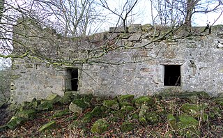
WHaining Place or The Haining in the Parish of Kilmarnock lies near an old fording place across the Cessnock Water in East Ayrshire, Parish of Riccarton, Scotland. Hanyng (sic) was the caput or laird's dwelling of the Barony of Haining-Ross with a tower house or keep located in a defensive position on a high promontory of land, half encircled by the river. Later Haining Place may have been a dower house, then a tenanted farm, finally being used as farm workers accommodation. Haining Place is now a ruin following a fire. The old farm of Haining Mains is still located nearby.
 W
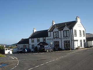
WKingarth is a historic village and parish on the Isle of Bute, off the coast of south-western Scotland. The village is within the parish of its own name, and is situated at the junction of the A844 and B881. In the Early Middle Ages it was the site of a monastery and bishopric and the cult centre of Saints Cathan and Bláán.
 W
WThe Lands of Kirkwood (NS3947) formed a small estate in the Parish of Stewarton, East Ayrshire lying between Stewarton and Dunlop, which in 1678 became part of the lands of Lainshaw, known as the Lainshaw, Kirkwood and Bridgehouse Estate. Kirkwood was anciently known as Bloak Cunninghame. Kirkwood remains as a farm in 2010.
 W
WThe ruins of the large courtyard style Kyle Castle, once also known as Cavil Castle or occasionally Dalblair Castle lie close to the hamlet of Dalblair in Auchinleck parish near Muirkirk in the East Ayrshire council area, Scotland. The castle stands at the confluence of the Guelt Water and the Glenmuirshaw Water on a peninsula carved out by these rivers. Its name suggests that it was once of some significance.
 W
WThe Lands of Ashgrove, previously known as Ashenyards formed a small estate in the Parish of Kilwinning, North Ayrshire, lying between Kilwinning and Stevenston. The Georgian mansion house was demolished in 1960, the substantial walled garden survives.
 W
WThe Lands of Blacklaw formed a small property of five merks worth, in the Lordship of Stewarton at the eastern extremity of Strathannick, between the hamlet of Kingsford in East Ayrshire and the East Renfrewshire boundary, Scotland. It was first recorded in 1484 in the Acta Auditorum. Black Law is a prominent whinstone crag lying above Blacklaw Hill Farm.
 W
WThe Lands of Borland formed an estate lying between Aiket Castle and the town of Dunlop, East Ayrshire, Parish of Dunlop, Scotland. The laird's house at Borland stood near the Sandy Ford over the Glazert Water. The names Bordland, Boreland, Borland, Laigh Borland, Low Borland and Nether Borland have all been applied to the site of the laird's house.
 W
WThe Lands of Borland or Boreland formed a castle and land holdings within the old Barony of Cumnock, East Ayrshire, Parish of Old Cumnock, Scotland. Lying two miles south of Cumnock the property was mainly held by a cadet branch of the Hamilton family from around 1400 before passing by marriage to the Montgomeries and others. For consistency the spelling 'Borland' will be used throughout.
WThe Lands of Dallars or Auchenskeith (NS463337) form a small estate in East Ayrshire, Hurlford, Kilmarnock, Parish of Riccarton, Scotland. The present mansion house is mainly late 18th-century, located within a bend of the Cessnock Water on the site of older building/s. "Dullers or Dillers" was changed to "Auchenskeith" or "Auchinskeigh" (sic) as well as other variants and then the name reverted back nearer to the original form as "Dollars" and then finally "Dallars". Dallars lies 3.25km south of Hurlford.
 W
WThe Lands of Pitcon, previously Potconnel now form a small estate of around 100 acres in the Parish of Dalry, North Ayrshire in the old Barony of Dalry. The present category B listed Georgian mansion house dating from 1787, replaces an older castellated dwelling. Pitcon lies on the outskirts of Drakemyres, now a suburb of Dalry, close to the confluence of the Rye Water, River Garnock, and the Mains Burn, standing on a low knoll. Such a marshy area would have provided a degree of protection to the old castle.
 W
WThe Lands of Templehouse formed a small estate lying between Aiket Castle and the town of Dunlop, East Ayrshire, Parish of Dunlop, Scotland. The laird's house at Templeland of Dunlop Hill, to give it its formal name, stood near to the ancient road leading from Dunlop to Kirkwood and on to Kennox. The lands were held by the Knights Templar until a date prior to 1570 when the Gemmells of Templehouse were granted the property and remained there until 1962, a period of around 500 years. The spelling 'Gemmell' is used for consistency except where otherwise denoted.