 W
WThe Albany Fish Traps, also known as the Oyster Harbour Fish Traps, are a series of fish traps situated in Oyster Harbour near the mouth of the Kalgan River approximately 14 kilometres (9 mi) east of Albany in the Great Southern region of Western Australia.
 W
WBlackwall Reach is a section of the Swan River in Western Australia.
 W
WBoyagin Rock is located 10 km (6.2 mi) south west of Brookton and 26 km (16 mi) north west of Pingelly in the Wheatbelt region of Western Australia, which is approximately 175 km (109 mi) south east of Perth. The Boyagin Rock outcrop rises 50 m (160 ft) above the surrounding land and is an crestal area of a granite inselberg within the geological Yilgarn Craton framework. The Boyagin Rock Nature Reserve that contains Boyagin Rock, is widely recognised as one of the few areas of original fauna and flora still intact on the Wheatbelt. It provides refuge for a variety of fauna including numbats, goannas, echidnas and Tammar wallabies.
 W
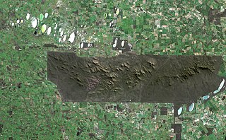
WJilakin Rock is a granite rock formation located approximately 15 km (9.3 mi) east of east of Kulin and approximately 25 km (16 mi) south of Kondinin in the central Wheatbelt region of Western Australia. It overlooks Jilakin Lake and is a prominent feature in the area, rising out of the surrounding flat plains.
 W
WLake Ewlyamartup is an ephemeral salt lake in the Great Southern region of Western Australia located approximately 17 km (11 mi) east of the town of Katanning and about 294 km (183 mi) south east of Perth.
WLake Towerrinning or Towerrinning Lake is a permanent brackish lake in the Wheatbelt region of Western Australia located approximately 32 km (20 mi) south of Darkan, 44 km (27 mi) south west of Wagin and about 245 km (152 mi) south east of Perth. The lake is managed by the Department of Parks and Wildlife since it is used as a recreational facility; the Shire of West Arthur leases part of it as a gazetted water ski area.
WLake Vancouver is a permanent freshwater lake in the Great Southern region of Western Australia located approximately 20 km (12 mi) south east of the town of Albany and about 438 km (272 mi) south east of Perth. The lake is listed in the South Coast significant Wetlands database and is part of a case study to help determine buffer zone guidelines for wetlands in Western Australia.
 W
WThe City of Melville local government area lies within the traditional lands of the Beeliar people, a subgroup of the Whadjuk dialectical group of the Noongar Indigenous Australians. These are several significant Noongar sites within the City of Melville.
 W
WMullalyup is a town in the South West region of Western Australia, situated between Kirup and Balingup on the South Western Highway, 231 kilometres (144 mi) south of Perth. The town is in the shire of Donnybrook-Balingup, known for its scenic Blackwood River Valley and agricultural industries.
WParkeyerring Lake is an ephemeral salt lake in the Wheatbelt region of Western Australia, approximately 7 km (4.3 mi) south of the town of Wagin and about 235 km (146 mi) southeast of Perth. Much of the lake is surrounded by the 991 ha (2,450-acre) Parkeyerring Nature Reserve, which was gazetted in 1905 and expanded in 1957.
 W
WPoint Walter is a point on the Swan River, Western Australia, notable for its large sandbar that extends into the river. It is located on the southern shore of Melville Water, and forms its western end. Point Walter is located in the suburb of Bicton, approximately 12 kilometres (7 mi) south of the Perth central business district, and 7 kilometres (4 mi) north-east of Fremantle, and is on the opposite side of the river to the suburbs of Mosman Park, Peppermint Grove, and Dalkeith.
 W
WPuntapin Rock is a granite rock formation located approximately 4 km (2.5 mi) south east of Wagin and approximately 30 km (19 mi) west of Dumbleyung in the western Wheatbelt region of Western Australia. It is a prominent feature in the area, rising out of the surrounding flat plains.
 W
WThe Stirling Range or Koikyennuruff is a range of mountains and hills in the Great Southern region of Western Australia, 337 km south-east of Perth. It is over 60 km (37 mi) wide from west to east, stretching from the highway between Mount Barker and Cranbrook eastward past Gnowangerup. The Stirling Range is protected by the Stirling Range National Park, which was gazetted in 1913, and has an area of 1,159 km2 (447 sq mi).
 W
WUpper Kalgan Hall is a heritage listed building and archaeological site located in Kalgan, close to the Kalgan River north east of Albany in the Great Southern region of Western Australia.
 W
WWave Rock is a natural rock formation that is shaped like a tall breaking ocean wave. The "wave" is about 15 m (49 ft) high and around 110 m (360 ft) long. It forms the north side of a solitary hill, which is known as "Hyden Rock". This hill, which is a granite inselberg, lies about 3 km (2 mi) east of the small town of Hyden and 296 km (184 mi) east-southeast of Perth, Western Australia. Wave Rock and Hyden Rock are part of a 160 ha (395-acre) nature reserve, Hyden Wildlife Park. More than 100,000 tourists visit every year.
 W
WWireless Hill Park is a 40-hectare (99-acre) park in Ardross, Western Australia that is the location of the former Applecross Wireless Station, an early radio station in Western Australia. The station buildings have been preserved and now house the Wireless Hill Museum. The site is listed in the Register of the National Estate. and the State Register of Heritage Places.