 W
WThe New Churchyard was a municipal and non-parochial burial ground in London. Established in 1569, it was used for burial from 1570 until 1739, by which date approximately 25,000 interments were estimated to have taken place. It was created to accommodate the ever-increasing number of new interments required as London's population expanded during 16th to 18th centuries. It was known as a "churchyard" despite not being associated with a church and, from the mid-17th century, became more commonly known as Bedlam or Bethlem burial ground because its location within the "Bedlam" or "Bethlem" area. The remains of the burial ground are now located under modern Liverpool Street, within the north-east corner of the City of London.
 W
WConvoys Wharf, formerly called the King's Yard, is the site of Deptford Dockyard, the first of the Royal Dockyards, built on a riverside site in Deptford, by the River Thames in London, England. It was first developed in 1513 by Henry VIII to build vessels for the Royal Navy. Convoys Wharf also covers most of the site of Sayes Court manor house and gardens, home of diarist John Evelyn.
 W
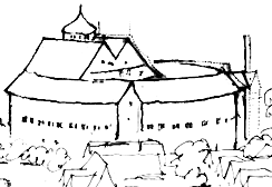
WCrofton Roman Villa in Crofton, Orpington, in the London Borough of Bromley, is a Roman villa which was inhabited between approximately 140 and 400 AD. It was the centre of a farming estate of about 500 acres (200 ha), with farm buildings nearby, surrounded by fields, meadows and woods. The house was altered several times during its 260 years of occupation, and at its largest it probably had at least 20 rooms.
 W
WFordcroft Anglo-Saxon cemetery was a place of burial. It is located in the town of Orpington in South East London, South-East England. Belonging to the Middle Anglo-Saxon period, it was part of the much wider tradition of burial in Early Anglo-Saxon England. Fordcroft was a mixed inhumation and cremation ceremony.
 W
WThe Globe Theatre was a theatre in London associated with William Shakespeare. It was built in 1599 by Shakespeare's playing company, the Lord Chamberlain's Men, on land owned by Thomas Brend and inherited by his son, Nicholas Brend and grandson Sir Matthew Brend, and was destroyed by fire on 29 June 1613. A second Globe Theatre was built on the same site by June 1614 and closed by an Ordinance issued on 6 September 1642.
 W
WGrim's Ditch or Grim's Dyke or Grimes Dike is a great earthwork in the London Borough of Harrow and lends its name to the gentle escarpment it crowns, marking Hertfordshire's border. It extended east-west about 6 miles (9.7 km) from the edge of Stanmore where an elevated neighbourhood of London, Stanmore Hill, adjoins Bushey Heath to the far north of Pinner Green – Cuckoo Hill. Today the remaining earthworks start mid-way at Harrow Weald Common. It takes its name from the likely Roman Britain-era earthwork which became called one of seven Grim's Ditches, a few of which have two or three rows, in central-to-southern England.
 W
WThe Keston Roman villa is an archaeological site in Keston in the London Borough of Bromley, England. The villa consisted of several buildings including a mausoleum. The latter is preserved above ground.
 W
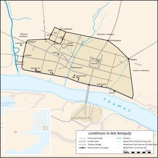
WLondinium, also known as Roman London, was the capital of Roman Britain during most of the period of Roman rule. It was originally a settlement established on the current site of the City of London around AD 47–50. It sat at a key crossing point over the River Thames which turned the city into a road nexus and major port, serving as a major commercial centre in Roman Britain until its abandonment during the 5th century.
 W
WThe London Charterhouse is a historic complex of buildings in Smithfield, London, dating back to the 14th century. It occupies land to the north of Charterhouse Square, and lies within the London Borough of Islington. Originally constructed as a Carthusian priory, on the site of a burial ground, at the Dissolution of the Monasteries it became one of the greatest palaces of Tudor London. In 1611, the property was bought by Thomas Sutton, a businessman and "the wealthiest commoner in England", who established a school for the young and an almshouse for the old. The almshouse remains today, although the school was re-established as Charterhouse School in Godalming, Surrey in 1872.
 W
WThe London Mithraeum, also known as the Temple of Mithras, Walbrook, is a Roman mithraeum that was discovered in Walbrook, a street in the City of London, during a building's construction in 1954. The entire site was relocated to permit continued construction and this temple of the mystery god Mithras became perhaps the most famous 20th-century Roman discovery in London.
 W
WThe London to Lewes Way is a 71 kilometres (44 mi) long Roman road between Watling Street at Peckham and Lewes in Sussex. The road passes through Beckenham and West Wickham, then crosses the North Downs above Titsey, on the county boundary between Surrey and Kent, and is overlain by Edenbridge High Street. The road continues on this alignment onto the high ground of Ashdown Forest, where the more grassy vegetation on the silted up outer ditches contrasts very clearly with surrounding heather in aerial photographs, then descends through Piltdown to Lewes, linking with the Sussex Greensand Way at Barcombe Mills and with a network of roads at Lewes.
WThe New Churchyard was a municipal and non-parochial burial ground in London. Established in 1569, it was used for burial from 1570 until 1739, by which date approximately 25,000 interments were estimated to have taken place. It was created to accommodate the ever-increasing number of new interments required as London's population expanded during 16th to 18th centuries. It was known as a "churchyard" despite not being associated with a church and, from the mid-17th century, became more commonly known as Bedlam or Bethlem burial ground because its location within the "Bedlam" or "Bethlem" area. The remains of the burial ground are now located under modern Liverpool Street, within the north-east corner of the City of London.
 W
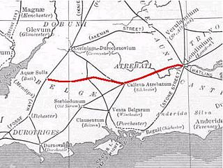
WThe Roman road from Silchester to Bath connected Calleva Atrebatum (Silchester) with Aquae Sulis (Bath) via Spinae (Speen), Cunetio and Verlucio. The road was a significant route for east–west travel and military logistics in southeast England during the 1st to 5th centuries.
 W
WThe Romano-British site, Wickham Court Farm is a Roman-era archaeological site in the London Borough of Bromley, situated south-east of West Wickham and south-west of Coney Hall. It is a Scheduled Ancient Monument.
 W
WThe Rose was an Elizabethan theatre. It was the fourth of the public theatres to be built, after The Theatre (1576), the Curtain (1577), and the theatre at Newington Butts – and the first of several playhouses to be situated in Bankside, Southwark, in a liberty outside the jurisdiction of the City of London's civic authorities. Its remains were excavated by archaeologists in 1989.
 W
WThe following is a list of Scheduled monuments in Greater London.
 W
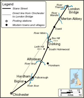
WStane Street is the modern name of the 91 km-long (57 mi) Roman road in southern England that linked Londinium (London) to Noviomagus Reginorum (Chichester). The exact date of construction is uncertain; however, on the basis of archaeological artefacts discovered along the route, it was in use by 70 AD and may have been built in the first decade of the Roman occupation of Britain.
 W
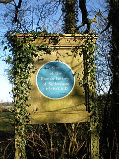
WSulloniacis or Sulloniacae is the name of a place in Roman Britain which is known only from an entry in the Antonine Itinerary, a listing of routes and facilities for the cursus publicus, the official courier service of the Roman Empire. Iter (Itinerary) II of the British section runs between Richborough and Chester (Deva), and this shows Sulloniacis on the road now known as Watling Street, nine Roman miles from St Albans (Verulamium) and 12 from London. Sulloniacis is usually identified with Roman remains found at Brockley Hill near Edgware in the London Borough of Barnet.
 W
WWatling Street is a historic route in England that crosses the River Thames at London and which was used in Classical Antiquity, Late Antiquity, and throughout the Middle Ages. It was used by the ancient Britons and paved as one of the main Roman roads in Britannia – Roman-governed Great Britain during the Roman Empire. The route linked Dover and London in the southeast via St Albans to Wroxeter to the northwest. Watling Street was the traditional site of the Romans' Defeat of Boudica, the line of the road was later the southwestern border of the Danelaw with Wessex and Mercia, and Watling Street was numbered as one of the major highways of medieval England.