 W
WThe Southern Maya Area (SMA) is a part of Mesoamerica, long believed important to the rise of Maya civilization, the period that is also known as Preclassic Maya. It lies within a broad arc or cantilevered rectangle from Chiapa de Corzo, in the Isthmus of Tehuantepec, in the northwest due south to Izapa and Paso de la Amada, from Chiapa de Corzo southeast to Copán, Honduras, and from Copán south to Chalchuapa, El Salvador.
 W
WBalberta is a major Mesoamerican archaeological site on the Pacific coastal plain of southern Guatemala, belonging to the Maya civilization. It has been dated to the Early Classic period and is the only known major site on the Guatemalan Pacific coastal plain to have exposed Early Classic architecture that has not been buried under posterior Late Classic construction. The site was related to the nearby site of San Antonio, which lies 6 kilometres (3.7 mi) to the west.
 W
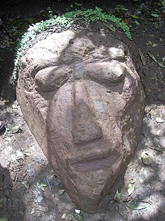
WEl Baúl is a Pre-Columbian archaeological site in present-day Escuintla Department, Guatemala. El Baúl, along with the sites of Bilbao and El Castillo, is part of the Cotzumalhuapa Archaeological Zone. It was occupied during the prehistoric Formative stage of the Americas.
 W
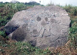
WBilbao is a Mesoamerican archaeological site about 1 mile (1.6 km) from the modern town of Santa Lucía Cotzumalguapa in the Escuintla department of Guatemala. The site lies among sugar plantations on the Pacific coastal plain and its principal phase of occupation is dated to the Classic Period. Bilbao was a major centre belonging to the Cotzumalhuapa culture with its main occupation dating to the Late Classic. Bilbao is the former name of the plantation on which the site lies and from which it has derived its name.
 W
WLa Blanca is a pre-Columbian Mesoamerican archaeological site in present-day La Blanca, San Marcos Department, western Guatemala. It has an occupation dating predominantly from the Middle Preclassic period of Mesoamerican chronology. This site belongs to the later period of the Mokaya culture.
 W
WCerro Quiac is a small Maya archaeological site located at an altitude of 2,635 metres (8,645 ft), overlooking the Plains of Urbina in the Guatemalan Highlands. When investigated in 1970 it had five stone sculptures, by 1977 only four were left. The sculptures included figures and geometric decoration. The site is still used for contemporary Maya rituals. Cerro Quiac is located in the northeast of the municipality of Cantel, within the boundaries of the hamlet of Chirijquiac.
 W
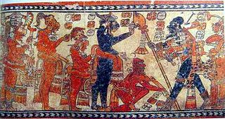
WChama (Chamá) is a small Late-Classic Maya highland site, situated in the Chixoy River valley of the Alta Verapaz department of Guatemala, some fifty kilometers north-west of San Pedro Carchah. Small-scale excavations were carried out in the early twentieth century by Robert J. Burkitt of the Pennsylvania University Museum. The site belongs to the periphery of the lowland Maya kingdoms. It has been argued that Chama was colonized from the lowlands somewhere at the beginning of the eighth century and then developed its characteristic, but short-lived Classical ceramic style.
 W
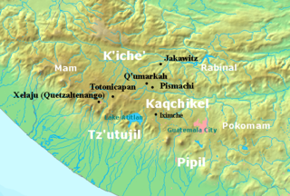
WChitinamit is an archeological site of the Maya civilization in the highlands of Guatemala. It has been identified as Jakawitz, the first capital of the K'iche' Maya. The site is located in the El Quiché department, in the municipality of Uspantán. Chitinamit dates from the Early Classic through to the Late Postclassic periods and covers approximately 2 hectares (220,000 sq ft), making it the largest site in its region.
 W
WChocolá is a Preclassic Southern Maya site whose developmental emphasis was from ca. 1000 BC to AD 200. The site lies within the Southern Maya area.
 W
WChojolom is a small Maya archaeological site in the western highlands of Guatemala. The site features a number of sculpted stones that are presumed to belong to the K'iche Maya culture of the Postclassic Period. Chojolom is situated on a hill in the municipality of Cantel, in the department of Quetzaltenango. The municipality is inhabited by K'iche' Maya to this day, who make up 93.8% of the local population. Cantel is located 10 kilometres (6.2 mi) from the modern city of Quetzaltenango at Kilometer 217 on the CA2 Highway. Chojolom is believed to have been a ritual site.
 W
WChutixtiox is an archaeological site of the ancient Maya civilization near Sacapulas, in the Quiché department of modern Guatemala. The site was excavated during the 20th century by A. Ledyard Smith. Ceramic evidence excavated at the site suggests a close relationship with the K'iche' capital of Q'umarkaj. Chutixtiox may have been a settlement in a polity that included the nearby sites of Chutinamit and Xolpacol.
 W
WCotzumalhuapa archaeological culture is from the piedmont area of the Escuintla Department, Guatemala. The Cotzumalhuapa archaeological zone is near the town of Santa Lucía Cotzumalguapa.
WGuaytán is an archaeological site of the Maya civilization in the municipality of San Agustín Acasaguastlán, in the department of El Progreso, in Guatemala. It is the most important pre-Columbian archaeological site of the middle drainage of the Motagua River.
 W
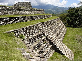
WIximcheʼ is a Pre-Columbian Mesoamerican archaeological site in the western highlands of Guatemala. Iximche was the capital of the Late Postclassic Kaqchikel Maya kingdom from 1470 until its abandonment in 1524. The architecture of the site included a number of pyramid-temples, palaces and two Mesoamerican ballcourts. Excavators uncovered the poorly preserved remains of painted murals on some of the buildings and ample evidence of human sacrifice. The ruins of Iximche were declared a Guatemalan National Monument in the 1960s. The site has a small museum displaying a number of pieces found there, including sculptures and ceramics. It is open daily.
 W
WKaminaljuyu is a Pre-Columbian site of the Maya civilization that was primarily occupied from 1500 BC to AD 1200. Kaminaljuyu has been described as one of the greatest of all archaeological sites in the New World by Michael Coe, although its remains today – a few mounds only – are far less impressive than other Maya sites more frequented by tourists. When first mapped scientifically, it comprised some 200 platforms and pyramidal mounds, at least half of which were created before the end of the Preclassic period. Debate continues about the size, scale, and degree by which, as an economic and political entity, it integrated both the immediate Valley of Guatemala and the Southern Maya area.
 W
WKʼatepan, also known as Yolchonabʼ, is an archaeological site of the ancient Maya civilization located 1 kilometre (0.62 mi) to the east of the modern town of San Mateo Ixtatán, in the Huehuetenango Department of Guatemala. The name Kʼatepan translates as "old church", while the alternate name of Yolchonabʼ means "in the village". The site consists of a small temple plaza in front of two large terraces set against a mountainside, accessed by broad stairways. The site was first described by Guatemalan historian Adrián Recinos in 1913. Recinos considered Kʼatepan to be the most important ceremonial site in the northern Sierra de los Cuchumatanes mountains. A preliminary map of Kʼatepan was produced in 2007.
WKʼo is one of several Mayan ceremonial center sites around and associated with the Classic Mayan city of Holmul located in modern-day Guatemala. Currently, the site boasts what may be the royal tomb of the earliest known Mayan ruler.
 W
WMixco Viejo, occasionally spelt Mixcu Viejo, is an archaeological site in the north east of the Chimaltenango department of Guatemala, some 50 kilometres (31 mi) to the north of Guatemala City and 4 kilometres (2.5 mi) from the junction of the rivers Pixcaya and Motagua. It is a moderate sized ruined city of the Postclassic Maya civilization.
WMontana is a Mesoamerican archaeological site on the Pacific coastal plain of southern Guatemala. It is located in the department of Escuintla, near Balberta, and is one of the largest Mesoamerican archaeological sites on the Pacific Coast of Guatemala.
WNebaj is an archaeological site of the pre-Columbian Maya civilization, located in the western Guatemala highlands near the Ixil village of Santa Maria Nebaj. What is now known as the Fenton Vase was excavated from this site. It is now held in the British Museum.
WNito was a trading post of the Maya civilization in Mesoamerica. The site was located at the mouth of the Dulce River, where the river empties into the Gulf of Honduras. The modern Guatemala city of San Gil de Buena Vista in Izabal Department now occupies the area.
WEl Portón is a site of the Preclassic Mesoamerican civilisation, literate and thought to be Maya.
 W
WQuiriguá is an ancient Maya archaeological site in the department of Izabal in south-eastern Guatemala. It is a medium-sized site covering approximately 3 square kilometres (1.2 sq mi) along the lower Motagua River, with the ceremonial center about 1 km (0.6 mi) from the north bank. During the Maya Classic Period (AD 200–900), Quiriguá was situated at the juncture of several important trade routes. The site was occupied by 200, construction on the acropolis had begun by about 550, and an explosion of grander construction started in the 8th century. All construction had halted by about 850, except for a brief period of reoccupation in the Early Postclassic. Quiriguá shares its architectural and sculptural styles with the nearby Classic Period city of Copán, with whose history it is closely entwined.
 W
WQʼumarkaj is an archaeological site in the southwest of the El Quiché department of Guatemala. Qʼumarkaj is also known as Utatlán, the Nahuatl translation of the city's name. The name comes from Kʼicheʼ Qʼumarkah "Place of old reeds".
 W
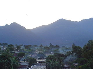
WSan Mateo Ixtatán is a municipality in the Guatemalan department of Huehuetenango. It is situated at 2,540 metres (8,330 ft) above sea level in the Cuchumatanes mountain range and covers 560 square kilometres (220 sq mi) of terrain. It has a cold climate and is located in a cloud forest. The temperature fluctuates between 0.5 and 20 °C. The coldest months are from November to January and the warmest months are April and May. The town has a population of 15,090 and is the municipal center for an additional 28,000 people living in the surrounding mountain villages. It has a weekly market on Thursday and Sunday. The annual town festival takes place from September 19 to September 21 honoring their patron Saint Matthew. The residents of San Mateo belong to the Chuj Maya ethnic group and speak the Mayan Chuj language, not to be confused with Chuj baths, or wood fired steam rooms that are common throughout the central and western highlands.
 W
WTak'alik Ab'aj is a pre-Columbian archaeological site in Guatemala. It was formerly known as Abaj Takalik; its ancient name may have been Kooja. It is one of several Mesoamerican sites with both Olmec and Maya features. The site flourished in the Preclassic and Classic periods, from the 9th century BC through to at least the 10th century AD, and was an important centre of commerce, trading with Kaminaljuyu and Chocolá. Investigations have revealed that it is one of the largest sites with sculptured monuments on the Pacific coastal plain. Olmec-style sculptures include a possible colossal head, petroglyphs and others. The site has one of the greatest concentrations of Olmec-style sculpture outside of the Gulf of Mexico.
 W
WThe site of Ujuxte is the largest Preclassic Maya site to be discovered on the Guatemalan Pacific coast. It is in the Retalhuleu Department, in western Guatemala.
 W
WWajxaklajun is a ruin of the ancient Maya civilization situated adjacent to the modern town of San Mateo Ixtatán, in the Huehuetenango Department of Guatemala. Wajxaklajun is considered to be the most important archaeological site in the San Mateo Ixtatán area. The site has been dated to the Classic period. The Chuj Maya consider the city to have been built by their ancestors. The site has similarities with other nearby highland Maya ruins; it is unusual for the presence of a number of stelae, a feature more associated with lowland sites during the Classic period, probably indicating some level of exchange with lowland cities.
 W
WZaculeu or Saqulew is a pre-Columbian Maya archaeological site in the highlands of western Guatemala, about 3.7 kilometres (2.3 mi) outside of the modern city of Huehuetenango. Occupation at the site dates to the Early Classic period (AD 250–600) of Mesoamerican history. Zaculeu was the capital of the Postclassic Mam kingdom, and was conquered by the K'iche' Kingdom of Q'umarkaj. It displays a mixture of Mam and K'iche' style architecture.