 W
WThe Aleutian subduction zone is a ~2500 mile-long convergence boundary between the North American Plate and the Pacific Plate, that extends from the Alaska Range to the Kamchatka Peninsula. Here, the Pacific Plate is being subducted underneath the North American plate and the rate of subduction changes from west to east from 7.5 cm/yr to 5.1 cm/yr. The Aleutian subduction zone includes two prominent features, the Aleutian arc and the Aleutian trench. The island arc was created via volcanic eruptions from dehydration of the subducting slab at ~100 km depth. The trench is a narrow and deep morphology that occurs between the two converging plates as the subucting slab dives beneath the overriding plate.
WThe Aleutian Trench is an oceanic trench along a convergent plate boundary which runs along the southern coastline of Alaska and the Aleutian islands. The trench extends for 3,400 kilometres (2,100 mi) from a triple junction in the west with the Ulakhan Fault and the northern end of the Kuril–Kamchatka Trench, to a junction with the northern end of the Queen Charlotte Fault system in the east. It is classified as a "marginal trench" in the east as it runs along the margin of the continent. The subduction along the trench gives rise to the Aleutian Arc, a volcanic island arc, where it runs through the open sea west of the Alaska Peninsula. As a convergent plate boundary, the trench forms part of the boundary between two tectonic plates. Here, the Pacific Plate is being subducted under the North American Plate at a dip angle of nearly 45°. The rate of closure is 7.5 centimetres (3 in) per year.
 W
WThe Cascadia subduction zone is a convergent plate boundary that stretches from northern Vancouver Island in Canada to Northern California in the United States. It is a very long, sloping subduction zone where the Explorer, Juan de Fuca and Gorda plates move to the east and slide below the much larger mostly continental North American Plate. The zone varies in width and lies offshore beginning near Cape Mendocino, Northern California, passing through Oregon and Washington, and terminating at about Vancouver Island in British Columbia.
 W
WThe Cotabato Trench is an oceanic trench in the Pacific Ocean, off the southwestern coast of Mindanao in the Philippines. Along this trench the oceanic crust of the Sunda Plate beneath the Celebes Sea is being subducted beneath the Philippines Mobile Belt. It forms part of a linked set of trenches along the western side of the Philippines formed over east-dipping subduction zones, including the Manila Trench and the Negros Trench. At its northern end the rate of convergence across this boundary is about 100 mm per year. It is a relatively young structure, forming during the late Miocene to Pliocene. This age is consistent with the estimated age of the sedimentary rocks in the accretionary wedge associated with the trench and the age of adakitic arc rocks on Mindanao thought to date the onset of subduction.
 W
WThe Hellenic subduction zone (HSZ) is where oceanic crust of the Nubian Plate is being subducted north–northeastwards beneath the Aegean Sea Plate. The southernmost and shallowest part of the zone is obscured beneath the deformed thick sedimentary sequence that forms the Mediterranean Ridge accretionary complex. It has a well-defined Wadati–Benioff zone of seismicity, which demonstrates the relatively shallow dip of its southern part, which increases markedly to the north of the non-volcanic part of the Hellenic arc. The descending slab has been imaged using seismic tomography down to the top of the mantle transition zone at 410 km depth.
 W
WThe Hikurangi Trench, also called the Hikurangi Trough, is an oceanic trench in the bed of the Pacific Ocean off the east coast of the North Island of New Zealand, lying between the southern end of the Cook Strait and the Chatham Rise. It is the southward continuation of the much deeper Kermadec Trench. It lies in the Hikurangi Margin subduction zone, which is the southern extension of the Kermadec-Tonga subduction zone. The Hikurangi Margin is the subduction zone where the thick oceanic Hikurangi Plateau is subducting beneath continental crust of the Indo-Australian Plate. By contrast, the Kermadec and Tonga trenches represent the parts of the subduction zone where oceanic crust of the Pacific Plate is subducting beneath oceanic crust of the Indo-Australian Plate.
 W
WThe Hjort Trench is a linear topographic depression south of Macquarie Island in the southwest Pacific Ocean. Geologically, the depression is considered to be the seafloor expression of an ocean-ocean subduction zone, where the Australian plate is thrusting beneath the Pacific Plate. As the southernmost portion of the Macquarie Ridge Complex, the Hjort Trench lies in an area of diagonal convergence produced by the transform fault evolution of the Emerald Fracture Zone. Frequent seismic events, most less than 20 km (12 mi) deep, characterize the transpression along this plate boundary.
 W
WThe Izu-Ogasawara Trench , also known as Izu-Bonin Trench, is an oceanic trench in the western Pacific Ocean, consisting of the Izu Trench and the Bonin Trench.
 W
WThe Japan Trench is an oceanic trench part of the Pacific Ring of Fire off northeast Japan. It extends from the Kuril Islands to the northern end of the Izu Islands, and is 8,046 metres (26,398 ft) at its deepest. It links the Kuril-Kamchatka Trench to the north and the Izu-Ogasawara Trench to its south with a length of 800 kilometres (497 mi). This trench is created as the oceanic Pacific plate subducts beneath the continental Okhotsk Plate. The subduction process causes bending of the down going plate, creating a deep trench. Continuing movement on the subduction zone associated with the Japan Trench is one of the main causes of tsunamis and earthquakes in northern Japan, including the megathrust Tōhoku earthquake and resulting tsunami that occurred on 11 March, 2011. The rate of subduction associated with the Japan Trench has been recorded at about 7.9–9.2 centimetres (3.1–3.6 in)/yr.
 W
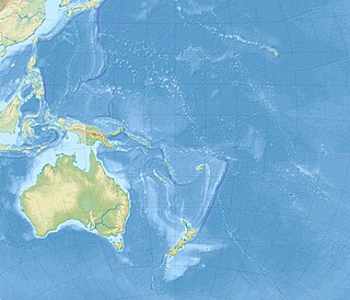
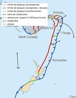
WThe Kermadec Trench is a linear ocean trench in the south Pacific Ocean. It stretches about 1,000 km (620 mi) from the Louisville Seamount Chain in the north (26°S) to the Hikurangi Plateau in the south (37°S), north-east of New Zealand's North Island. Together with the Tonga Trench to the north, it forms the 2,000 km (1,200 mi)-long, near-linear Kermadec-Tonga subduction system, which began to evolve in the Eocene when the Pacific Plate started to subduct beneath the Australian Plate. Convergence rates along this subduction system are among the fastest on Earth, 80 mm (3.1 in)/yr in the north and 45 mm (1.8 in)/yr in the south.
 W
WThe Kermadec-Tonga subduction zone is a convergent plate boundary that stretches from the North Island of New Zealand northward. The formation of the Kermadec and Tonga Plates started about 4–5 million years ago. Today, the eastern boundary of the Tonga Plate is one of the fastest subduction zones, with a rate up to 24 cm/yr. The trench formed between the Kermadec-Tonga and Pacific Plates is also home to the second deepest trench in the world, at about 10,800 m, as well as the longest chain of submerged volcanoes.
 W
WThe Kuril–Kamchatka Trench or Kuril Trench is an oceanic trench in the northwest Pacific Ocean. It lies off the southeast coast of Kamchatka and parallels the Kuril Island chain to meet the Japan Trench east of Hokkaido. It extends from a triple junction with the Ulakhan Fault and the Aleutian Trench near the Commander Islands, Russia, in the northeast, to the intersection with the Japan Trench in the southwest.
 W
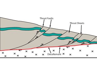
WThe Main Frontal Thrust (MFT), also known as the Himalayan Frontal Thrust (HFT) is a geological fault in the Himalayas
 W
WThe Main Himalayan Thrust (MHT) is a décollement under the Himalaya Range. This thrust fault follows a NW-SE strike, reminiscent of an arc, and gently dip towards the north, beneath the region. It is the largest active continental megathrust fault in the world.
 W
WThe Makran Trench is the physiographic expression of a subduction zone along the northeastern margin of the Gulf of Oman adjacent to the southwestern coast of Balochistan of Pakistan and the southeastern coast of Iran. In this region the oceanic crust of the Arabian Plate is being subducted beneath the continental crust of the Eurasian Plate.
 W
WThe Manila Trench is an oceanic trench in the Pacific Ocean, located west of the islands of Luzon and Mindoro in the Philippines. The trench reaches a depth of about 5,400 metres (17,700 ft), in contrast with the average depth of the South China Sea of about 1,500 metres (4,900 ft). It is created by subduction, in which the Sunda Plate is subducting under the Philippine Mobile Belt, producing this almost N-S trending trench. The convergent boundary is terminated to the north by the Taiwan collision zone, and to the south by the Mindoro terrane. It is an area pervaded by negative gravity anomalies.
 W
WThe Mariana Trench or Marianas Trench is located in the western Pacific Ocean about 200 kilometres (124 mi) east of the Mariana Islands; it is the deepest oceanic trench on Earth. It is crescent-shaped and measures about 2,550 km (1,580 mi) in length and 69 km (43 mi) in width. The maximum known depth is 10,984 metres (36,037 ft) at the southern end of a small slot-shaped valley in its floor known as the Challenger Deep. However, some unrepeated measurements place the deepest portion at 11,034 metres (36,201 ft). If Mount Everest were placed into the trench at this point, its peak would still be under water by more than two kilometres (1.2 mi).
 W
WThe Middle America Trench is a major subduction zone, an oceanic trench in the eastern Pacific Ocean off the southwestern coast of Middle America, stretching from central Mexico to Costa Rica. The trench is 1,700 miles (2,750 km) long and is 21,880 feet at its deepest point. The trench is the boundary between the Rivera, Cocos, and Nazca plates on one side and the North American and Caribbean plates on the other. It is the 18th-deepest trench in the world. Many large earthquakes have occurred in the area of the Middle America Trench.
 W
WThe Nankai Trough is a submarine trough located south of the Nankaidō region of Japan's island of Honshū, extending approximately 900 km (559 mi) offshore. The underlying fault, the Nankai megathrust, is the source of the devastating Nankai megathrust earthquakes, while the trough itself is potentially a major source of hydrocarbon fuel, in the form of methane clathrate.
 W
WThe Philippine Trench is a submarine trench to the east of the Philippines. The trench is located in the Philippine sea of the western North Pacific Ocean and continues NNW-SSE. It has a length of approximately 1,320 kilometres and a width of about 30 km (19 mi) from the center of the Philippine island of Luzon trending southeast to the northern Maluku island of Halmahera in Indonesia. At its deepest point, the trench reaches 10,540 meters (34,580 ft) or (5,760 fathoms).
 W
WThe Puerto Rico Trench is located on the boundary between the Caribbean Sea and the Atlantic Ocean. The oceanic trench, the deepest in the Atlantic, is associated with a complex transition between the Lesser Antilles subduction zone to the south and the major transform fault zone or plate boundary, which extends west between Cuba and Hispaniola through the Cayman Trough to the coast of Central America.
WThe 6,300-metre (20,700 ft) deep Puysegur Trench is a deep cleft in the floor of the south Tasman Sea formed by the subduction of the Indo-Australian Plate under the Pacific Plate to the south of New Zealand. Immediately to its east lies a ridge, a northern extension of the Macquarie Ridge, which separates the Puysegur Trench from the Solander Trough. To the west is the expanse of the Tasman Basin, which stretches most of the distance to Australia. To the north of the trench lies the Fiordland Basin, which can be considered an extension of the trench. The Puysegur Trench mirrors the Kermadec Trench and Tonga Trench north of New Zealand.
 W
WThe Ryukyu Trench , also called Nansei-Shotō Trench, is a 1398 km (868 mi) long oceanic trench located along the southeastern edge of Japan's Ryukyu Islands in the Philippine Sea in the Pacific Ocean, between northeastern Taiwan and southern Japan. The trench has a maximum depth of 7460 m (24,476 ft). The trench is the result of oceanic crust of the Philippine Plate obliquely subducting beneath the continental crust of the Eurasian Plate at a rate of approximately 52 mm/yr. In conjunction with the adjacent Nankai Trough to the northeast, subduction of the Philippine plate has produced 34 volcanoes. The largest earthquake to have been recorded along the Ryukyu Trench, the 1968 Hyūga-nada earthquake, was magnitude 7.5 and occurred along the northernmost part of the trench on 1 April 1968. This earthquake also produced a tsunami.
 W
WThe Sagami Trough also Sagami Trench, Sagami Megathrust, or Sagami Subduction Zone is a 340-kilometre (210 mi)long trough, which is the surface expression of the convergent plate boundary where the Philippine Sea Plate is being subducted under the Okhotsk Plate. It stretches from the Boso Triple Junction in the east, where it meets the Japan Trench, to Sagami Bay in the west, where it meets the Nankai Trough. It runs north of the Izu Islands chain and the Izu-Bonin-Mariana Arc (IBM).
 W
WThe South Sandwich Trench is a deep arcuate trench in the South Atlantic Ocean lying 100 kilometres (62 mi) to the east of the South Sandwich Islands. It is the deepest trench of the Southern Atlantic Ocean, and the second deepest of the Atlantic Ocean after the Puerto Rico Trench. Since the trench extends south of the 60th parallel south, it also contains the deepest point in the Southern Ocean.
 W
WThe South Shetland Trough is an undersea trough located north of the South Shetland Islands. It is the remnant of a subduction zone where the defunct Phoenix Plate, now part of the Antarctic Plate, subducted under the Antarctic Peninsula and the South Shetland Islands.
 W
WThe Sunda Trench, earlier known as and sometimes still indicated as the Java Trench, is an oceanic trench located in the Indian Ocean near Sumatra, formed where the Australian-Capricorn plates subduct under a part of the Eurasian Plate. It is 3,200 kilometres (2,000 mi) long with a maximum depth of 7,290 metres. Its maximum depth is the deepest point in the Indian Ocean. The trench stretches from the Lesser Sunda Islands past Java, around the southern coast of Sumatra on to the Andaman Islands, and forms the boundary between Indo-Australian Plate and Eurasian plate. The trench is considered to be part of the Pacific Ring of Fire as well as one of a ring of oceanic trenches around the northern edges of the Australian Plate.
 W
WSuruga Trough is a trough that lies off the coast of Suruga Bay in Japan, forming part of the Nankai Trough, the latter being responsible the source of many large earthquakes in Japan's history. Both mark the boundary of the Philippine Sea Plate subducting under the Amurian Plate.
WThe Tonga Trench is an oceanic trench located in the south-west Pacific Ocean. It is the deepest trench of the Southern Hemisphere and the second deepest on Earth. The fastest plate tectonic velocity on Earth occurs here, as the Pacific Plate is being subducted westward in the trench.
WThe Tonga-Kermadec Ridge is an oceanic ridge in the south-west Pacific Ocean underlying the Tonga-Kermadec island arc. It is the most linear, fastest converging, and most seismically active subduction boundary on Earth, and consequently has the highest density of submarine volcanoes.
 W
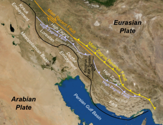
WThe Zagros fold and thrust belt is an approximately 1,800-kilometre (1,100 mi) long zone of deformed crustal rocks, formed in the foreland of the collision between the Arabian Plate and the Eurasian Plate. It is host to one of the world's largest petroleum provinces, containing about 49% of the established hydrocarbon reserves in fold and thrust belts (FTBs) and about 7% of all reserves globally.