 W
WCherokee history is the written and oral lore, traditions, and historical record maintained by the living Cherokee people and their ancestors. In the 21st century, leaders of the Cherokee people define themselves as those persons enrolled in one of the three federally recognized Cherokee tribes: The Eastern Band of Cherokee Indians, The Cherokee Nation, and The United Keetoowah Band of Cherokee Indians. The first live predominantly in North Carolina; the latter two tribes are based in what is now Oklahoma, and was Indian Territory when they were forcibly relocated there. The Cherokee people have extensive written records, including detailed genealogical records, preserved in the Cherokee language, known as the Cherokee syllabary, and in the English language.
 W
WThe Anglo–Cherokee War, was also known from the Anglo-European perspective as the Cherokee War, the Cherokee Uprising, or the Cherokee Rebellion. The war was a conflict between British forces in North America and Cherokee bands during the French and Indian War. The British and the Cherokee had been allies at the start of the war, but each party had suspected the other of betrayals. Tensions between British-American settlers and Cherokee warriors of towns that the pioneers encroached on, increased during the 1750s, culminating in open hostilities in 1758.
 W
WThe Battle of Echoee, or Etchoe Pass, was a battle on June 27, 1760 during the French and Indian War, between the British and colonial force under Archibald Montgomerie and a force of Cherokee warriors under Seroweh. It took place near the present-day municipality of Otto, in Macon County, North Carolina.
 W
WThe Charles Robertson Grant, also known more simply as the Watauga Grant, was a transaction for the sale of land by the Cherokee Nation to Charles Robertson. The transaction occurred at Sycamore Shoals on the Watauga River on March 19, 1775. The Charles Robertson Grant was for a large tract in what is now East Tennessee and Western North Carolina, some of which had been previously leased from the Cherokee.
 W
WThe Cherokee in the American Civil War were active in the Trans-Mississippi and Western Theaters. In the east, Confederate Cherokees led by William Holland Thomas hindered Union forces trying to use the Appalachian mountain passes of western North Carolina and eastern Tennessee. Out west, Confederate Cherokee Stand Watie led primarily Native Confederate forces in the Indian Territory, in what is now the state of Oklahoma. The Cherokee partnered with the Confederacy in order to get funds, as well as ultimately full recognition as a sovereign, independent state.
 W
WThe Cherokee Nation was a legal, autonomous, tribal government in North America recognized from 1794 to 1907. It was often referred to simply as "The Nation" by its inhabitants. The government was effectively disbanded in 1907, after its land rights had been extinguished, prior to the admission of Oklahoma as a state. During the late 20th century, the Cherokee people reorganized, instituting a government with sovereign jurisdiction known as the Cherokee Nation. On July 9, 2020, the United States Supreme Court ruled that the Muscogee (Creek) Nation had never been actually disestablished in the years before allotment and Oklahoma Statehood.
 W
WThe Cherokee Path was the primary route from Charleston to Columbia, South Carolina in Colonial America, connecting all of the Cherokee towns and territories along the Savannah River. These were known as the Lower Towns, in contrast to the Middle Towns in Western North Carolina and the Overhill Towns in present-day southeastern Tennessee.
 W
WThe Cherokee–American wars, also known as the Chickamauga Wars, were a series of raids, campaigns, ambushes, minor skirmishes, and several full-scale frontier battles in the Old Southwest from 1776 to 1795 between the Cherokee and American settlers on the frontier. Most of the events took place in the Upper South. While the fighting stretched across the entire period, there were extended periods with of little or no action.
 W
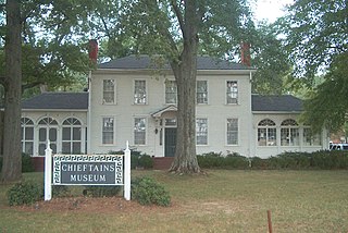
WChieftains Museum, also known as the Major Ridge Home, is a two-story white frame house built around a log house of 1792 in Cherokee country. It was the home of the Cherokee leader Major Ridge. He was notable for his role in negotiating and signing the Treaty of New Echota of 1835, which ceded the remainder of Cherokee lands in the Southeast to the United States. He was part of a minority group known as the Treaty Party, who believed that relocation was inevitable and wanted to negotiate the best deal with the United States for their people.
 W
WChota is a historic Overhill Cherokee town site in Monroe County, Tennessee, in the southeastern United States. Developing after nearby Tanasi, Chota was the most important of the Overhill towns from the late 1740s until 1788. It replaced Tanasi as the de facto capital, or 'mother town' of the Cherokee people.
 W
WCitico is a prehistoric and historic Native American site in Monroe County, Tennessee, in the southeastern United States. The site's namesake Cherokee village was the largest of the Overhill towns, housing an estimated population of 1,000 by the mid-18th century. The Mississippian village that preceded the site's Cherokee occupation is believed to have been the village of "Satapo" visited by the Juan Pardo expedition in 1567.
 W
WFort Watauga, more properly Fort Caswell, was an American Revolutionary War fort that once stood at the Sycamore Shoals of the Watauga River in what is now Elizabethton, Tennessee. The fort was originally built in 1775–1776 by the area's frontier government, the Watauga Association, to help defend Watauga settlers from Native American attacks, which were in part instigated by the British. Fort Watauga was originally named Fort Caswell after North Carolina Governor Richard Caswell.
 W
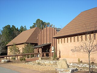
WThe Funk Heritage Center in Waleska, Georgia, is Georgia's official frontier and southeastern Indian interpretive center. Located on the campus of Reinhardt University, the center houses a gallery of Native American artifacts and artwork, as well as a theater, which features a short film on the history of Native Americans in the southeastern United States. A small souvenir shop is also available.
 W
WThe Georgia land lotteries were an early nineteenth century system of land redistribution in Georgia. Under this system, white male citizens could register for a chance to win lots of land that had been stolen from the Creek Indians and the Cherokee Nation. The lottery system was utilized by the State of Georgia between the years 1805 and 1833 “to strengthen the state and increase the population in order to increase Georgia's power in the House of Representatives.” Although some other states used land lotteries, none were implemented at the scale of the Georgia contests.
 W
WThe Great Grant Deed, also known as The Great Grant, was a transaction for the sale of property by the Cherokee Nation to Richard Henderson and Company. The grant is also known as the Lousia purchase or the Transylvania purchase. The transaction occurred at Sycamore Shoals on the Watauga River on March 17, 1775. The Great Grant was for lands forming Henderson's new Transylvania Colony comprising much of what is now the state of Kentucky.
 W
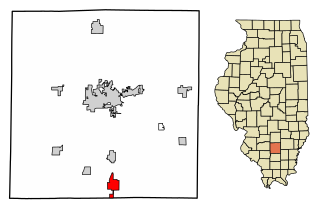
WIna is the southernmost village in Jefferson County, Illinois, United States. The population was 2,338 as of the 2010 census. It is part of the Mount Vernon Micropolitan Statistical Area.
 W
WJudaculla Rock is a curvilinear-shaped outcrop of soapstone with quarry scars and petroglyphs. It is located on a 0.85-acre rectangular-shaped property, owned by Jackson County, approximately 60 meters east of Caney Fork Creek, a major branch of the northwestward-trending Tuckasegee River, in the mountains of western North Carolina.
 W
WThe Keetoowah Nighthawk Society was a Cherokee organisation formed ca. 1900 that intended to preserve and practice traditional "old ways" of tribal life, based on religious nationalism. It was led by Redbird Smith, a Cherokee National Council and original Keetoowah Society member. It formed in the Indian Territory that was superseded by admission of Oklahoma as a state, during the late-nineteenth century period when the federal government was breaking up tribal governments and communal lands under the Dawes Act and Curtis Act. The Nighthawks arose in response to weakening resolve on the part of Cherokee leaders—including the original Keetoowah Society, a political organization created by Cherokee Native American full bloods, in or about 1859—to continue their resistance on behalf of the Cherokee after the Dawes Commission began forcing the transfer of Oklahoma tribal lands in the Indian Territory to individual ownership in the 1890s.
 W
WLong Island, also known as Long Island of the Holston, is an island in the Holston River at Kingsport in East Tennessee. Important in regional history since pre-colonial times, the island is listed on the National Register of Historic Places and is designated as a U.S. National Historic Landmark District.
 W
WThe Lucy Walker steamboat disaster was an 1844 steamboat accident caused by the explosion of the boilers of the steamboat Lucy Walker near New Albany, Indiana, on the Ohio River. The explosion occurred on the afternoon of Wednesday, October 23, 1844, when the steamer's three boilers exploded, set the vessel on fire, and sank it. It was one of a number of similar accidents of early 19th-century riverine transportation that led to important federal legislation and safety regulations. The vessel's owner was a Native American; her crew were African-American slaves, and her passengers represented a cross-section of frontier travelers.
 W
WOconaluftee is a river valley in the Great Smoky Mountains of North Carolina, located in the Southeastern United States. Formerly the site of a Cherokee village and Appalachian community, the valley's bottomland is now home to the main entrance to the North Carolina side of the Great Smoky Mountains National Park.
 W
WThe Oconaluftee Indian Village is a replica of an 18th-century eastern Cherokee community located in Cherokee, North Carolina, United States along the Oconaluftee River.
WOverhill Cherokee was the term for the Cherokee people located in their historic settlements in what is now the U.S. state of Tennessee in the Southeastern United States, on the west side of the Appalachian Mountains. This name was used by 18th-century European traders and explorers from British colonies along the Atlantic coast, as they had to cross the mountains to reach these settlements.
 W
WThe Path Grant Deed is a document regarded as a first step toward the American westward migration across the Appalachian Mountains, resulting from negotiations at Sycamore Shoals in March 1775. The land acquired within the boundaries of the Path Grant allowed Daniel Boone to develop the Wilderness Road free from attack or claims by the Cherokee. The Path Grant was recorded on November 15, 1794 by the Hawkins County, Tennessee registrar in Deed Book #1, pages 147-151
 W
WRed Clay State Historic Park is a state park located in southern Bradley County, Tennessee established in 1979. The park is also listed as an interpretive center along the Cherokee Trail of Tears. It encompasses 263 acres (1.06 km2) of land and is located just above the Tennessee-Georgia stateline.
 W
WRosa laevigata, the Cherokee rose, is a white, fragrant rose native to southern China and Taiwan south to Laos and Vietnam, and invasive in the United States.
 W
WRoss's Landing in Chattanooga, Tennessee, is the last site of the Cherokee's 61-year occupation of Chattanooga and is considered to be the embarkation point of the Cherokee removal on the Trail of Tears. Ross's Landing Riverfront Park memorializes the location, which is listed on the National Register of Historic Places.
WThe Siege of Fort Loudoun was an engagement during the Anglo-Cherokee War fought from February 1760 to August 1760 between the warriors of the Cherokee led by Ostenaco and the garrison of Fort Loudoun composed of British and colonial soldiers commanded by Captain Paul Demeré.
 W
WThe Sycamore Shoals of the Watauga River, usually shortened to Sycamore Shoals, is a rocky stretch of river rapids along the Watauga River in Elizabethton, Tennessee. Archeological excavations have found Native Americans lived near the shoals since prehistoric times, and Cherokees gathered there. As Europeans began settling the Trans-Appalachian frontier, the shoals proved strategic militarily, as well as shaped the economies of Tennessee and Kentucky. Today, the shoals are protected as a National Historic Landmark and are maintained as part of Sycamore Shoals State Historic Park.
 W
WThe Texas–Indian wars were a series of 19th-century conflicts between settlers in Texas and the Southern Plains Indians. These conflicts began when the first wave of European-American settlers moved into Spanish Texas. They continued through Texas's time as part of Mexico, when more Europeans and Anglo-Americans arrived, to the subsequent declaration of independence by the Republic of Texas. The conflicts did not end until thirty years after Texas joined the United States.
 W
WTrail of Tears State Park is a public recreation area covering 3,415 acres (1,382 ha) bordering the Mississippi River in Cape Girardeau County, Missouri. The state park stands as a memorial to those Cherokee Native Americans who died on the Cherokee Trail of Tears. The park's interpretive center features exhibits about the Trail of Tears as well as displays and specimens of local wildlife. An archaeological site in the park was added to the National Register of Historic Places in 1970.
 W
WThe Treaty of Holston was a treaty between the United States government and the Cherokee signed on July 2, 1791, and proclaimed on February 7, 1792. It was negotiated and signed by William Blount, governor of the Southwest Territory and superintendent of Indian affairs for the southern district for the United States, and various representatives of the Cherokee peoples, most notably John Watts. The treaty established terms of relations between the United States and the Cherokee, and established that the Cherokee tribes were to fall under the protection of the United States, with the United States managing all future foreign affairs for all the loosely affiliated Cherokee tribes.
 W
WThe Treaty With The Cherokee, 1798, also known as the First Treaty of Tellico, was signed on October 2, 1798, in the Overhill Cherokee settlement of Great Tellico near Tellico Blockhouse in Tennessee. This treaty served as an addendum to the Treaty of Holston and was the only treaty between the United States and Native Americans executed during the administration of President John Adams. The treaty was signed by Thomas Butler and George Walton, commissioners of the United States, and some thirty-nine Cherokee chiefs and warriors, in the presence of Silas Dinsmoor, Agent of the United States among the Cherokee, and thirteen other witnesses including Charles R. Hicks, who served as interpreter.