 W
WThe regions of ancient Greece were areas identified by the ancient Greeks as geographical sub-divisions of the Hellenic world. These regions are described in the works of ancient historians and geographers, and in the legends and myths of the ancient Greeks.
 W
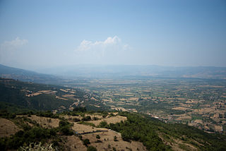
WAinis or Aeniania, was a region of ancient Greece located near Lamia in modern Central Greece, roughly corresponding to the upper Valley of Spercheios.
 W
WAmfilochia is a town and a municipality in the northwestern part of Aetolia-Acarnania in Greece, on the site of ancient Amfilochia. Under the Ottoman Empire, it was known as Karvasaras.
 W
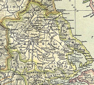
WAnciently, Magnesia was a region of Ancient Greece, eventually absorbed by ancient Thessaly. Originally inhabited by the Magnetes (Μάγνητες), Magnesia was the long and narrow slip of country between Mounts Ossa and Pelion on the west and the sea on the east, and extending from the mouth of the Peneius on the north to the Pagasaean Gulf on the south. The Magnetes were members of the Amphictyonic League, and were settled in this district in the Homeric times, and mentioned in the Iliad. The Thessalian Magnetes are said to have founded the Asiatic cities of Magnesia ad Sipylum and Magnesia on the Maeander. The towns of Magnesia were: Aesonis, Aphetae, Boebe, Casthanaea, Cercinium, Coracae, Demetrias, Eurymenae, Glaphyrae, Homole or Homolium, Iolcus, Magnesia, Meliboea, Methone, Mylae, Nelia, Olizon, Pagasae, Rhizus, Spalaethra, and Thaumacia.
 W
WAttica, or the Attic peninsula, is a historical region that encompasses the city of Athens, the capital of Greece. It is a peninsula projecting into the Aegean Sea, bordering on Boeotia to the north and Megaris to the west. The southern tip of the peninsula, known as Laurion, was an important mining region.
 W
WBisaltia or Bisaltica was an ancient country which was bordered by Sintice on the north, Crestonia on the west, Mygdonia on the south and was separated by Odomantis on the north-east and Edonis on the south-east by river Strymon.The eponymous inhabitants, known as the Bisaltae, were a Thracian people. Later, the region was annexed by the kingdom of Macedon and became one of its districts. The most important town in Bisaltia was the Greek city of Argilos. There was also a river named Bisaltes in the region, which has not been certainly identified.
 W
WBoleron was the name of a region and a Byzantine province in southwestern Thrace during the Middle Ages.
 W
WChech or Chechko is a geographical and historical region of the Balkan peninsula in southeastern Europe in modern-day Bulgaria and Greece. It consists of about 60 settlements and was traditionally mostly Pomak with an Orthodox Greek and Bulgarian minorities.
WCrestonia was an ancient region immediately north of Mygdonia. The Echeidorus river, which flowed through Mygdonia into the Thermaic Gulf, had its source in Crestonia. It was partly occupied by a remnant of the Pelasgi, who spoke a different language from their neighbors ; later the Greeks.
 W
WCrusis or Crousis was called a maritime district of North-West Chalcidice from Potidaea to the Thermaic Gulf. It was named after Crusis the son of Mygdon. The cities of Crusis were: Lipaxus, Combreia, Lisaea, Gigonus, Campsa, Smila, Aeneia and later Antigonia Psaphara.
 W
WCynuria is an ancient district on the eastern coast of the Peloponnese, between the Argolis and Laconia, so called from the Cynurians, one of the most ancient tribes in the peninsula. It was believed to have taken its name from the mythical Cynurus.
 W
WDolopia is a mountainous region of Greece, located north of Aetolia.
WEdonis or Edonida, also transliterated as Edonia, was an ancient region of Thrace which later became a district of Macedon. Its name is derived from the ancient Thracian inhabitants of the region, the Edonians. It was bordered by Odomantice in the north, Bisaltia in the west, and the Aegean Sea in the south, and was separated from Thrace proper by the river Nestos in the east.
 W
WOpuntian Locris or Eastern Locris was an ancient Greek region inhabited by the eastern division of the Locrians, the so-called tribe of the Locri Epicnemidii or Locri Opuntii.
 W
WGreat Wallachia or Great Vlachia, or simply Vlachia, was a province in southeastern Thessaly in the late 12th century, and was used to denote the entire region of Thessaly in the 13th and 14th centuries. The name derives from the Vlachs (Aromanians), who had lived across much of the area.
WHistiaeotis or Hestiaeotis was a northwest district of ancient Thessaly, part of the Thessalian tetrarchy, roughly corresponding to modern Trikala regional unit. Anciently, it was inhabited by the Hestiaeotae (Ἑστιαιῶται), and the Peneius may be described in general as its southern boundary. It occupied the passes of Mount Olympus, and extended westward as far as Pindus. The demonym of the district's inhabitants is Histiaeotes. In epigraphy, the regional name occurs as Hestiōtai, ambassadors in Athens and Histiōtai in the Thessalian grain decree for Rome but most similarly written names are related to Histiaea, an Attic deme and a city in North Euboea. The epigraphical Aeolic Greek vocalism of Hestiaeotis is bizarre and idiomatic.
 W
WKarli-Eli, also Karli-Ili or Karlo-Ili, was the Ottoman name for the region of Aetolia-Acarnania in western Greece, which formed a distinct administrative unit from the late 15th century until the Greek War of Independence.
 W
WAlissos is a village and a community in the municipal unit of Dymi, Achaea, Greece. It is located near the Gulf of Patras, 3 km east of Kato Achaia, 3 km southwest of Kaminia and 17 km southwest of Patras. The community consists of the villages Alissos, Kamenitsa, Paralia Alissou and Profitis Elissaios. The Greek National Road 9 and the railway from Patras to Pyrgos run between Alissos and Paralia Alissou.
WOpuntian Locris or Eastern Locris was an ancient Greek region inhabited by the eastern division of the Locrians, the so-called tribe of the Locri Epicnemidii or Locri Opuntii.
 W
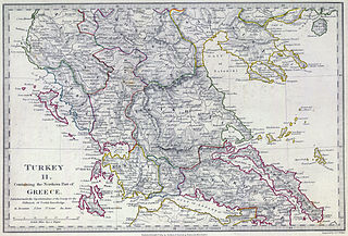
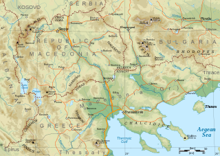
WMacedonia is a geographical and historical region of the Balkan Peninsula in Southeast Europe. Its boundaries have changed considerably over time; however, it came to be defined as the modern geographical region by the mid 19th century. Today the region is considered to include parts of six Balkan countries: Greece, North Macedonia, Bulgaria, and smaller parts in Albania, Serbia, and Kosovo. It covers approximately 67,000 square kilometres (25,869 sq mi) and has a population of 4.76 million.
 W
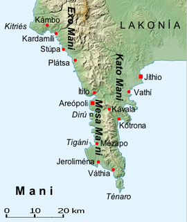
WThe Mani Peninsula, also long known by its medieval name Maina or Maïna (Μαΐνη), is a geographical and cultural region in southern Greece that is home to the Maniots, who claim descent from the ancient Spartans. The capital citiy of Mani is Areopoli. Mani is the central peninsula of the three which extend southwards from the Peloponnese in southern Greece. To the east is the Laconian Gulf, to the west the Messenian Gulf. The Mani peninsula forms a continuation of the Taygetos mountain range, the western spine of the Peloponnese.
 W
WMegaris was a small but populous state of ancient Greece, west of Attica and north of Corinthia, whose inhabitants were adventurous seafarers, credited with deceitful propensities. The capital, Megara, was famous for white marble and fine clay. Mount Geraneia dominates the center of the region. The island of Salamis was originally under the control of Megara, before it was lost to Athens in the late 7th century BCE.
 W
WAlmopia, or Enotia, also known in the Middle Ages as Moglena, is a municipality and a former province (επαρχία) of the Pella regional unit in Macedonia, Greece. The seat of the municipality is the town Aridaia. The municipality has an area of 985.817 km2.
 W
WThe Molossians were a group of ancient Greek tribes which inhabited the region of Epirus in classical antiquity. Together with the Chaonians and the Thesprotians, they formed the main tribal groupings of the northwestern Greek group. On their northern frontier, they neighbored the Chaonians and on their southern frontier neighbored the kingdom of the Thesprotians. They formed their own state around 370 BC and were part of the League of Epirus. The most famous Molossian ruler was Pyrrhus of Epirus, considered one of the greatest generals of antiquity. The Molossians sided against Rome in the Third Macedonian War and were defeated. Following the war, 150,000 Molossians and other Epirotes were enslaved and transported to the Roman Republic, overwhelmingly in Italy itself.
 W
WOdomanti or Odomantes were an ancient Thracian tribe. Some regard it as Paeonian, while others claim, that the tribe was with certainty Thracian. The Odomanti are noted by Herodotus, Thucydides, Stephanus of Byzantium and Pliny the Elder.
 W
WOrchomenus or Orchomenos was an ancient city of Arcadia, Greece, called by Thucydides the Arcadian Orchomenus, to distinguish it from the Boeotian town.
 W
WPheneus or Pheneos was a town in the northeast of ancient Arcadia. Its territory, called Pheniatis, was bounded on the north by that of the Achaean towns of Aegeira and Pellene, east by the Stymphalia, west by the Cleitoria, and south by the Caphyatis and Orchomenia. This territory is shut in on every side by lofty mountains, offshoots of Mount Cyllene and the Aroanian chain; and it is about 7 miles in length and the same in breadth. Two streams descend from the northern mountains, and unite their waters about the middle of the valley; the united river bore in ancient times the name of Olbius and Aroanius. There is no opening through the mountains on the south; but the waters of the united river are carried off by subterranean channels (katavóthra) in the limestone rocks, and, after flowing underground, reappear as the sources of the river Ladon. In order to convey the waters of this river in a single channel to the katavóthra, the inhabitants at an early period constructed a canal, 50 stadia in length, and 30 feet in breadth. This great work, which was attributed to Heracles, had become useless in the time of Pausanias, and the river had resumed its ancient and irregular course; but traces of the canal of Heracles are still visible, and one bank of it was a conspicuous object in the valley when it was visited by William Martin Leake in 1806. The canal of Heracles, however, could not protect the valley from the danger to which it was exposed, in consequence of the katavóthra becoming obstructed, and the river finding no outlet for its waters. The Pheneatae related that their city was once destroyed by such an inundation, and in proof of it they pointed out upon the mountains the marks of the height to which the water was said to have ascended. Pausanias evidently refers to the yellow border which is still visible upon the mountains and around the plain: but in consequence of the great height of this line upon the rocks, it is difficult to believe it to be the mark of the ancient depth of water in the plain, and it is more probably caused by evaporation; the lower parts of the rock being constantly moistened, while the upper are in a state of comparative dryness, thus producing a difference of colour in process of time. It is, however, certain that the Pheneatic plain has been exposed more than once to such inundations. Pliny the Elder says that the calamity had occurred five times; and Eratosthenes related a memorable instance of such an inundation through the obstruction of the katavóthra, when, after they were again opened, the water rushing into the Ladon and the Alpheius overflowed the banks of those rivers at Olympia. The account of Eratosthenes has been confirmed by a similar occurrence in modern times. In 1821 the katavóthra became obstructed, and the water continued to rise in the plain till it had destroyed 7 to 8 square miles of cultivated country. Such was its condition till 1832, when the subterraneous channels again opened, the Ladon and Alpheius overflowed, and the plain of Olympia was inundated. Other ancient writers allude to the katavóthra and subterraneous course of the river of Pheneus.
WPheneus or Pheneos was a town in the northeast of ancient Arcadia. Its territory, called Pheniatis, was bounded on the north by that of the Achaean towns of Aegeira and Pellene, east by the Stymphalia, west by the Cleitoria, and south by the Caphyatis and Orchomenia. This territory is shut in on every side by lofty mountains, offshoots of Mount Cyllene and the Aroanian chain; and it is about 7 miles in length and the same in breadth. Two streams descend from the northern mountains, and unite their waters about the middle of the valley; the united river bore in ancient times the name of Olbius and Aroanius. There is no opening through the mountains on the south; but the waters of the united river are carried off by subterranean channels (katavóthra) in the limestone rocks, and, after flowing underground, reappear as the sources of the river Ladon. In order to convey the waters of this river in a single channel to the katavóthra, the inhabitants at an early period constructed a canal, 50 stadia in length, and 30 feet in breadth. This great work, which was attributed to Heracles, had become useless in the time of Pausanias, and the river had resumed its ancient and irregular course; but traces of the canal of Heracles are still visible, and one bank of it was a conspicuous object in the valley when it was visited by William Martin Leake in 1806. The canal of Heracles, however, could not protect the valley from the danger to which it was exposed, in consequence of the katavóthra becoming obstructed, and the river finding no outlet for its waters. The Pheneatae related that their city was once destroyed by such an inundation, and in proof of it they pointed out upon the mountains the marks of the height to which the water was said to have ascended. Pausanias evidently refers to the yellow border which is still visible upon the mountains and around the plain: but in consequence of the great height of this line upon the rocks, it is difficult to believe it to be the mark of the ancient depth of water in the plain, and it is more probably caused by evaporation; the lower parts of the rock being constantly moistened, while the upper are in a state of comparative dryness, thus producing a difference of colour in process of time. It is, however, certain that the Pheneatic plain has been exposed more than once to such inundations. Pliny the Elder says that the calamity had occurred five times; and Eratosthenes related a memorable instance of such an inundation through the obstruction of the katavóthra, when, after they were again opened, the water rushing into the Ladon and the Alpheius overflowed the banks of those rivers at Olympia. The account of Eratosthenes has been confirmed by a similar occurrence in modern times. In 1821 the katavóthra became obstructed, and the water continued to rise in the plain till it had destroyed 7 to 8 square miles of cultivated country. Such was its condition till 1832, when the subterraneous channels again opened, the Ladon and Alpheius overflowed, and the plain of Olympia was inundated. Other ancient writers allude to the katavóthra and subterraneous course of the river of Pheneus.
 W
WPopoli is a historical region of Western Macedonia, between the cities of Kastoria and Kleisoura.
 W
WPrespa is a region shared between North Macedonia, Albania and Greece. It shares the same name with the two Prespa lakes which are situated in the middle of the region. The largest town is Resen in North Macedonia with 9,000 inhabitants.
 W
WPsophis was an ancient Greek city in the northwest end of Arcadia, bounded on the north by Arcadia, and on the west by Elis. It was located near the modern village Psofida, part of the municipality Kalavryta.
 W
WRoumlouki or Kampania (Καμπανία), is the traditional name of the northeastern part of Imathia located in Macedonia, Greece, specifically the plain of the lower Aliakmon River.
WSintice or Sintike was an ancient region and later district of the kingdom of Macedon. It was located north of Bisaltia and Odomantike up to Messapio mount and west of Crestonia and South Paeonia to Strymon river and Orvilos mount. Its name is derived from the Sintians, a tribe which once inhabited the region. Beyond it, was stretching Medike which was held by the powerful Thracian tribe of Medi with which the Macedonians were in constant wars.
 W
WSkorta was a name used in the 13th and 14th centuries, during the period of Frankish rule in the Peloponnese, to designate the mountainous western half of the region of Arcadia, which separated the coastal plains of the western (Elisian) and southwestern (Messinian) Peloponnese from the Arcadian plateau in the interior. The name is found chiefly in the various-language editions of the Chronicle of the Morea. It also appears as Skodra and Skorda, in the chronicle of Pseudo-Dorotheos of Monemvasia.
 W
WTegea was a settlement in ancient Arcadia, and it is also a former municipality in Arcadia, Peloponnese, Greece. Since the 2011 local government reform it is part of the Tripoli municipality, of which it is a municipal unit with an area of 118.350 km2. It is near the modern villages of Alea and Episkopi.
 W
WThrace is a geographical and historical region in Southeast Europe, now split among Bulgaria, Greece, and Turkey, which is bounded by the Balkan Mountains to the north, the Aegean Sea to the south, and the Black Sea to the east. It comprises southeastern Bulgaria, northeastern Greece, and the European part of Turkey. The region's boundaries are based on that of the Roman Province of Thrace; the lands inhabited by the ancient Thracians extended in the north to modern-day Northern Bulgaria and Romania and to the west into the region of Macedonia.
 W
WTriphylia was an area of the ancient Peloponnese. Strabo and Pausanias both describe Triphylia as part of Elis, and it fell at times under the domination of the city of Elis, but Pausanias claims they reckoned themselves Arcadian, not Elean. They fell under the rule of Elis in the 8th century BC, and remained under Elean rule until the Spartans asserted their control in 402 BC. When the Spartans were defeated by the Thebans at the Battle of Leuctra in 371 BC, the Eleans attempted to reassert their control, but the Triphylians, in order to maintain their independence from Elis, joined the Arcadian League in 368 BC. In this period, their political fortunes were often shared by the areas on the border between Elis and Arcadia but in to the north of the River Alpheus; Xenophon mentions the Amphidolians and Acrorians and the city-states of Lasion, Margana, and Letrini in this context. The Amphidolians, Marganians, and Letrinians are remarkable in Xenophon for fielding slingers for the Peloponnesian army.
WTymphaea or Tymphaia was an ancient Greek territory, specifically located in the region of Epirus, inhabited by the Tymphaioi, a northwestern Greek tribe that belonged to the Molossian tribal state or koinon. The tribal territory was annexed by and became a province of the Kingdom of Macedon, specifically Upper Macedonia, in the 4th century BC.