 W
WAlfalfa County is a county located in the U.S. state of Oklahoma. As of the 2010 census, the population was 5,642. The county seat is Cherokee.
 W
WThe Apache Trail in Arizona was a stagecoach trail that ran through the Superstition Mountains. It was named the Apache Trail after the Apache Indians who originally used this trail to move through the Superstition Mountains.
 W
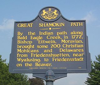
WThe Bald Eagle Creek Path was a major Native American trail in the U.S. State of Pennsylvania that ran from the Great Island on the West Branch Susquehanna River southwest to what is now the village of Frankstown on the Frankstown Branch Juniata River. The path ran from Clinton County southwest through Centre County and a small part of Blair County to its southern end in Blair County. It was part of a "Warriors Path", an important connector between paths leading to New York and the Six Nations of the Iroquois and the Ohio River country in the north and west, and paths leading to what are now Maryland, Virginia, and the Carolinas in the south.
 W
WBethlehem Pike is a historic 42.21 mi (67.93 km) long road in the U.S. state of Pennsylvania, connecting Philadelphia and Bethlehem, Pennsylvania. It began as a Native American path called the Minsi Trail which developed into a colonial highway called the King's Road in the 1760s. Most of the route later became part of U.S. Route 309, now Pennsylvania Route 309.
 W
WThe Big Spring near Luthersburg, Brady Township, Clearfield County, Pennsylvania, was an important camp site and trail hub for the Great Shamokin Path and the Goschgoschink Path.
 W
WThe Boston Post Road was a system of mail-delivery routes between New York City and Boston, Massachusetts, that evolved into one of the first major highways in the United States.
 W
WThe Bridger Trail, also known as the Bridger Road and Bridger Immigrant Road, was an overland route connecting the Oregon Trail to the gold fields of Montana. Gold was discovered in Virginia City, Montana in 1863, prompting settlers and prospectors to find a trail to travel from central Wyoming to Montana. In 1863, John Bozeman and John Jacobs scouted the Bozeman Trail, which was a direct route to the Montana gold fields through the Powder River Country. At the time the region was controlled by the Sioux, Cheyenne and Arapaho, who stepped up their raids in response to the stream of settlers along the trail.
 W
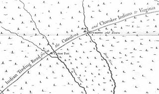
WThe Cherokee Path was the primary route from Charleston to Columbia, South Carolina in Colonial America, connecting all of the Cherokee towns and territories along the Savannah River. These were known as the Lower Towns, in contrast to the Middle Towns in Western North Carolina and the Overhill Towns in present-day southeastern Tennessee.
 W
WThe Cherokee Trail was a historic overland trail through the present-day U.S. states of Oklahoma, Kansas, Colorado, and Wyoming that was used from the late 1840s up through the early 1890s. The route was established in 1849 by a wagon train headed to the gold fields in California. Among the members of the expedition were a group of Cherokee. When the train formed in Indian Territory, Lewis Evans of Evansville, Arkansas, was elected Captain. Thus, this expedition is sometimes written as the Evans/Cherokee Train. In 1850 four wagon trains turned west on the Laramie Plains, along Wyoming's southern border to Fort Bridger.
 W
WCulbertson's Path was a Native American trail in north central Pennsylvania in the United States, which connected the Great Island Path with the Sheshequin Path. The eastern / southern end of the path was on the West Branch Susquehanna River at what is now the village of Allenwood in Gregg Township, Union County. The northern / western end was in Old Lycoming Township just north of what is now the city of Williamsport in Lycoming County.
 W
WThe Dalton Trail is a trail that runs between Pyramid Harbor, west of Haines, Alaska in the United States, and Fort Selkirk, in the Yukon Territory of Canada, using the Chilkat Pass. It is 396 km (246 mi) long.
 W
WEl Camino Real is the name that the Spanish gave to a trail they cleared in the 1680s, mostly over the traditional trails of Native Americans, from St. Augustine westward to the Spanish missions in north Florida. Before this time, transpeninsular traffic in La Florida between the western mission settlements and the capital depended on water routes from Apalachee to St. Augustine. Agricultural commodities produced in Apalachee were carried by canoes to the Gulf of Mexico and southward on the coast to the mouth of the Suwanee River, then upriver to a location on the Santa Fe River. There they were loaded onto pack animals or the backs of Indian burderners (porters) for the remainder of the overland trip. Provisions and funds from the real situado were sent on the same route in reverse.
 W
WThe Great Indian Warpath (GIW)—also known as the Great Indian War and Trading Path, or the Seneca Trail—was that part of the network of trails in eastern North America developed and used by Native Americans which ran through the Great Appalachian Valley. The system of footpaths extended from what is now upper New York to deep within Alabama. Various Indians traded and made war along the trails, including the Catawba, numerous Algonquian tribes, the Cherokee, and the Iroquois Confederacy. The British traders' name for the route was derived from combining its name among the northeastern Algonquian tribes, Mishimayagat or "Great Trail", with that of the Shawnee and Delaware, Athawominee or "Path where they go armed".
 W
WThe Great Island Path was a major Native American trail in the U.S. state of Pennsylvania that ran from the village of Shamokin along the right bank of the West Branch Susquehanna River north and then west to the Great Island.
 W
WGreat Minquas Path was a 17th-century trade route that ran through southeastern Pennsylvania from the Susquehanna River, near Conestoga, to the Schuylkill River, opposite Philadelphia. The 80-mile (130 km) east-west trail was the primary route for fur trading with the Minquas people. Dutch, Swedish and English settlers fought one another for control of it.
 W
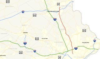
WThe Great Shamokin Path was a major Native American trail in the U.S. State of Pennsylvania that ran from the native village of Shamokin along the left bank of the West Branch Susquehanna River north and then west to the Great Island. There it left the river and continued further west to Chinklacamoose and finally Kittanning on the Allegheny River.
 W
WThe Great Trail was a network of footpaths created by Algonquian and Iroquoian-speaking indigenous peoples prior to the arrival of European colonists in North America. It connected the areas of New England and eastern Canada, and the mid-Atlantic regions to each other and to the Great Lakes region. Many major highways in the Northeastern United States were later constructed to follow the routes established thousands of years ago by Native Americans moving along these trails.
 W
WThe Kittanning Path was a major east-west Native American trail that crossed the Allegheny Mountains barrier ridge connecting the Susquehanna River valleys in the center of Pennsylvania to the highlands of the Appalachian Plateau and thence to the western lands beyond drained by the Ohio River. Kittanning Village was the first major Delaware (Lenape) Indian settlement along the descent from the Allegheny Plateau.
 W
WThe Great Osage Trail, also known as the Osage Trace or the Kaw Trace was one of the more well-known Native American trails through the countryside of what are today called the Midwest and Plains States of the U.S., pathways originally created by herds of Buffalo or other migrating wildlife.
 W
WThe Mohawk Trail began as a Native American trade route which connected Atlantic tribes with tribes in Upstate New York and beyond. It followed the Millers River, Deerfield River and crossed the Hoosac Range, in the area that is now northwestern Massachusetts.
 W
WThe Mojave Road, also known as Old Government Road, is a historic route and present day dirt road across what is now the Mojave National Preserve in the Mojave Desert in the United States. This rough road stretched 147 miles (237 km) from Beale's Crossing, to Fork of the Road location along the north bank of the Mojave River where the old Mojave Road split off from the route of the Old Spanish Trail/Mormon Road.
 W
WThe Natchez Trace, also known as the "Old Natchez Trace", is a historic forest trail within the United States which extends roughly 440 miles (710 km) from Nashville, Tennessee, to Natchez, Mississippi, linking the Cumberland, Tennessee, and Mississippi rivers.
 W
WNemacolin's Trail, or less often Nemacolin's Path, was an ancient Native American trail that crossed the great barrier of the Allegheny Mountains via the Cumberland Narrows Mountain pass, connecting the watersheds of the Potomac River and the Monongahela River in the present-day United States of America. Nemacolin's Trail connected what are now Cumberland, Maryland and Brownsville, Pennsylvania.
 W
WOakville is an unincorporated community located in the southeast corner of Lawrence County, Alabama, United States. The community has two parks, one dedicated to 20th-century African-American athlete Jesse Owens and the other to Middle Woodland period and Cherokee Native Americans.
 W
WThe Old Connecticut Path was the Native American trail that led westward from the area of Massachusetts Bay to the Connecticut River Valley, the first of the North American trails that led west from the settlements close to the Atlantic seacoast, towards the interior. The earliest colonists of Massachusetts Bay Colony used it, and rendered it wider by driving cattle along it. The old route is still followed, for part of its length, by Massachusetts Route 9 and Massachusetts Route 126.
 W
WOld Portage Road, also known as Old French Road and as French Portage Trail, was a Native American trail and later a road in present-day Chautauqua County, New York, that connected Lake Erie and Chautauqua Lake, and thereby the Great Lakes and the Mississippi River systems. Lake Erie is approximately 700 feet above sea level; the continental crest on this portage route between the St. Lawrence and Mississippi drainage basins is approximately 1500 feet above sea level.
 W
WThe Old San Antonio Road was a historic roadway located in the U.S. states of Texas and Louisiana. Parts of it were based on traditional Native American trails. Its Texas terminus was about 35 miles (56 km) southeast of Eagle Pass at the Rio Grande in Maverick County, and its northern terminus was at Natchitoches, Louisiana. The road continued from Texas through Monclova to Mexico City.
 W
WThe Old Spanish Trail is a historical trade route that connected the northern New Mexico settlements of Santa Fe, New Mexico with those of Los Angeles, California and southern California. Approximately 700 mi (1,100 km) long, the trail ran through areas of high mountains, arid deserts, and deep canyons. It is considered one of the most arduous of all trade routes ever established in the United States. Explored, in part, by Spanish explorers as early as the late 16th century, the trail saw extensive use by pack trains from about 1830 until the mid-1850s.
 W
WThe Old Wire Road is a historic road in Missouri and Arkansas. Several local roads are still known by this name. It followed an old Native American route, the Great Osage Trail across the Ozarks and became a road along a telegraph line from St. Louis, Missouri, to Fort Smith, Arkansas. This route was also used by the Butterfield Overland Mail. It was known as the "Wire Road" while the telegraph line was up, but when the line was later removed, it simply became known as the "Old Wire Road". In St. Louis, where the road begins at Jefferson Barracks, it is called Telegraph Road. From St. Louis to Springfield, Missouri, it became designated Route 14.
 W
WThe Pine Creek Path was a major Native American trail in the U.S. State of Pennsylvania that ran north along Pine Creek from the West Branch Susquehanna River near Long Island to the headwaters of the Genesee River.
 W
WThe Santa Fe Trail was a 19th-century route through central North America that connected Franklin, Missouri with Santa Fe, New Mexico. Pioneered in 1821 by William Becknell, who departed from the Boonslick region along the Missouri River, the trail served as a vital commercial highway until 1880, when the railroad arrived in Santa Fe. Santa Fe was near the end of the El Camino Real de Tierra Adentro, which carried trade from Mexico City.
 W
WThe Santa Susana Pass, originally Simi Pass, is a low mountain pass in the Simi Hills of Southern California, connecting the San Fernando Valley and Los Angeles neighborhood of Chatsworth, to the city of Simi Valley and eponymous valley.
 W
WThe Sauk Trail was originally a Native American trail running through what are present-day Illinois, Indiana and Michigan in the United States. From west to east, the trail ran from Rock Island on the Mississippi River to the Illinois River near modern Peru then along the north bank of that river to Joliet, and on to Valparaiso, Indiana. Then it ran northeasterly to La Porte and into southern Michigan running through Niles, Sturgis, Ypsilanti, and ending at the Detroit River near Detroit.
 W
WThe Sheshequin Path was a major Native American trail in the U.S. State of Pennsylvania that ran between two Native American villages: "French Margaret's Town" on the West Branch Susquehanna River and "Sheshequin" on the North Branch of the Susquehanna River. The path ran north and east along Lycoming Creek in Lycoming County and followed much of Towanda Creek in Bradford County. It was a shortcut between the two main branches of the Susquehanna River and was used by early settlers as well as Native Americans.
 W
WThe Siskiyou Trail stretched from California's Central Valley to Oregon's Willamette Valley; modern-day Interstate 5 follows this pioneer path. Originally based on existing Native American foot trails winding their way through river valleys, the Siskiyou Trail provided the shortest practical travel path between early settlements in California and Oregon.
 W
WThe Southwest Trail was a 19th-century pioneer route that was the primary passageway for American settlers bound for Texas.
 W
WThe Taos Mountain Trail was the historic pathway for trade and business exchanges between agrarian Taos and the Great Plains (Colorado) from pre-history through the Spanish Colonial period and into the time of the European and American presence. The Taos Mountain Trail, between northern New Mexico and southern Colorado, connected the high mountain traders and their trading partners north and south of the Sangre de Cristo Mountains. Also called the Trapper's Trail, the pathway was only wide enough for people on foot or horses in single file, but it shortened a trip from Taos to the plains farther north from nearly two weeks to three days in good weather. The Taos Mountain Trail was also known as the Sangre de Cristo Trail and the Aztec Trail.
 W
WThe Trading Path is not simply one wide path, as many named historic roads were or are. It was a corridor of roads and trails between the Chesapeake Bay region and the Cherokee, Catawba, and other Native-American groups in the Piedmont region of North Carolina, South Carolina, and Georgia. Indians had used and maintained much of the path for their expansive trading network for centuries prior to its use by Europeans and/or European-Americans. Indian and later European/European-American settlements occupied key points along the path. That section of the Trading Path through the Carolina piedmont was also known as the Upper Road, and a portion between North Carolina and Georgia was called the Lower Cherokee Traders Path.
 W
WTrail trees, trail marker trees, crooked trees, prayer trees, thong trees, or culturally modified trees are hardwood trees throughout North America that Native Americans intentionally shaped with distinctive characteristics that convey that the tree was shaped by human activity rather than deformed by nature or disease. A massive network of constructed pre-Columbian roads and trails have been well documented across the Americas, and in many places remnants can still be found of trails used by hunters and gatherers. One unique characteristic of the trail marker tree is a horizontal bend several feet off the ground, which makes it visible at greater distances, even in snow. Even today, modern hunters look for horizontal shapes while hunting deer, elk, and moose. Dr. Janssen noted in 1941:Among the many crooked trees encountered, only a few are Indian trail markers. The casual observer often experiences difficulty in distinguishing between accidentally deformed trees and those ... purposely bent by the Indians. Deformities may occur in many ways. A large tree may fall upon a sapling, pinning it down for a sufficient length of time to establish a permanent bend. Lightning may split a trunk, causing a portion to fall or lean in such a way as to resemble an Indian marker. Wind, sleet snow or depredations by animals may cause accidental deformities in trees. However, such injuries leave scars which are apparent to the careful observer, and these may serve in distinguishing such trees from Indian trail markers.
 W
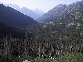
WWhite Pass, also known as the Dead Horse Trail, is a mountain pass through the Boundary Ranges of the Coast Mountains on the border of the U.S. state of Alaska and the province of British Columbia, Canada. It leads from Skagway, Alaska, to the chain of lakes at the headwaters of the Yukon River, Crater Lake, Lake Lindeman, and Bennett Lake.
 W
WThe Wilderness Road was one of two principal routes used by colonial and early national era settlers to reach Kentucky from the East. Although this road goes through the Cumberland Gap into southern Kentucky and northern Tennessee, the other is sometimes called the "Cumberland Road" because it started in Fort Cumberland in Maryland. Despite Kentucky Senator Henry Clay's advocacy of this route, early in the 19th century, the northern route was selected for the National Road, connecting near Washington, Pennsylvania into the Ohio Valley of northern Kentucky and Ohio.
 W
WThe Wyalusing Path or trail was a historical trace that ran from what is now Wyalusing to the Native American village of Canaserage in Pennsylvania in the United States. Wyalusing is on the east bank of the North Branch of the Susquehanna River in Bradford County and Muncy is on the east bank of the West Branch Susquehanna River in Lycoming County, so the path provided a short cut between the two main branches of the Susquehanna River. The alternative and much longer route was to follow the North Branch south from Wyalusing to the confluence with the West Branch at the Native village of Shamokin, then north up the West Branch to Muncy.
 W
WZane's Trace is a frontier road constructed under the direction of Col. Ebenezer Zane through the Northwest Territory of the United States, in what is now the state of Ohio. Many portions were based on traditional Native American trails. Constructed during 1796 and 1797, the road ran from Wheeling, Virginia to Maysville, Kentucky, through the portion of the Northwest Territory that eventually became the southeastern quarter of the state of Ohio. It was more than 230 miles (370 km) long and was interrupted by several rivers.