 W
WThe Imperial Territory of Alsace-Lorraine was a territory created by the German Empire in 1871 after it annexed most of Alsace and the Moselle department of Lorraine following its victory in the Franco-Prussian War. The Alsatian part lay in the Rhine Valley on the west bank of the Rhine River and east of the Vosges Mountains. The Lorraine section was in the upper Moselle valley to the north of the Vosges.
 W
WThe Champagne wine region is a wine region within the historical province of Champagne in the northeast of France. The area is best known for the production of the sparkling white wine that bears the region's name. EU law and the laws of most countries reserve the term "Champagne" exclusively for wines that come from this region located about 160 kilometres (100 miles) east of Paris. The viticultural boundaries of Champagne are legally defined and split into five wine-producing districts within the historical province: Aube, Côte des Blancs, Côte de Sézanne, Montagne de Reims, and Vallée de la Marne. The towns of Reims and Épernay are the commercial centers of the area. Reims is famous for its cathedral, the venue of the coronation of the French Kings and a UNESCO World Heritage Site.
 W
WThe foothill zone of the Upper Rhine Plain is the hill country in front of the mountains either side of the Upper Rhine Plain, especially those in front of the Black Forest, Vosges and Palatinate Forest. When the rift valley sank the foothills on the flanks of the mountain ranges were left hanging as fault blocks. The strata of the platform have been preserved in this zone, whereas they have been eroded from the neighbouring higher blocks. They are usually covered by a layer of loess and offer good conditions for agricultural use. For example, in Baden, the Alsace and the Palatinate intensive orchard and vineyard cultivation is practised in the foothill zone.
 W
WThe Forest of Argonne is a long strip of mountainous and wild woodland in northeastern France, approximately 200 km (120 mi) east of Paris, France. In 1792 Charles François Dumouriez outmaneuvered the invading forces of the Duke of Brunswick in the forest before the Battle of Valmy.
 W
WThe region of German Lorraine was the German-speaking part of Lorraine, now in France, that existed for centuries until into the 20th century. The name is also used more specifically in to refer to Bezirk Lothringen, that part of Lorraine that belonged to the German Empire from 1871–1918.
 W
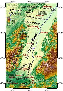
WThe Grand Ried is an Alsatian natural region which is part of the Ried. It shows landscapes typical of the Ried. To the west, it is delimited by the Ill, and by the Rhine to the east. It stretches between Strasbourg and Colmar. It was formed by the meandering Rhine, before it was canalised. The Rhine used to spread its sediments when inundations occurred. Today the Rhine is corseted between embankments.
 W
WLorraine Regional Natural Park is a protected area of pastoral countryside in the Grand Est region of northeastern France. The park covers a total area of 205,000 hectares. The parkland spreads between the cities of Metz and Nancy and spans three departments.
 W
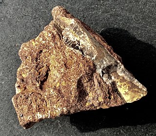
WMinette is a type of mineral deposit, consisting of iron ore of sedimentary origin, found in the south of Luxembourg and in Lorraine. Minette ore was deposited in the Early Jurassic and Middle Jurassic.
 W
WThe Alsatian ried consists of meadows liable to flooding, and of gallery forests, the vegetation of which is lush. The ried was formed by the then meandering Rhine, before it was canalised. The Petit Ried lies north of Strasbourg, whereas the Grand Ried lies south of Strasbourg. The town of Rhinau possesses 1000 ha of the last example of a temperate gallery forest in Western Europe, which is located on the right bank of the Rhine.
 W
WThe Woëvre is a natural region of Lorraine in northeastern France. It forms part of Lorraine plateau and lies largely in the department of Meuse. Along with the Côtes de Moselle, the Woëvre is one of the areas in Lorraine that receives the least rainfall; nonetheless, its river system is very important and feeds into the Lac de Madine.