 W
WMorocco spans from the Mediterranean Sea and Atlantic Ocean on the north and the west respectively, into large mountainous areas in the interior body, to the Sahara desert in the far south. Morocco is a Northern African country, located in the extreme north west of Africa on the edge of continental Europe. The strait of Gibraltar separates Spain off Morocco with a 13 kilometres (8.1 mi) span of water. Morocco borders the North Atlantic Ocean to the west, and the west Mediterranean Sea to the north.
 W
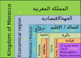
WIn Morocco, the 75 second-level administrative subdivisions are 13 prefectures and 62 provinces. They are subdivisions of the 12 regions of Morocco. Each prefecture or province is subdivided into arrondissements, municipalities or urban municipalities in other urban areas, and districts in rural areas. The districts are subdivided into rural municipalities. One prefecture (Casablanca) is also subdivided into préfectures d'arrondissements, similar to districts (cercles) except they are grouping a few arrondissements instead of rural municipalities.
 W
WChaouia is a historical and ethno-geographical region of Morocco. It is bounded by the Oum Er-Rbia River to its southwest, the oued Cherrate to its northeast, the plain of Tadla to the southeast and the Atlantic Ocean to the northwest. The enclave covers a land area of nearly 14 000 km².
 W
WDoukkala is a natural region of Morocco made of fertile plains and forests. Nowadays it is part of the Casablanca-Settat administrative region.
 W
WIfni was a Spanish province on the Atlantic coast of Morocco, south of Agadir and across from the Canary Islands.
 W
WRharb is a historical and geographical region in northern Morocco. This is a great plain, an area of about six thousand square kilometers in central Morocco, in northeast of Rabat and northwest of Meknes, bordered by the Atlantic Ocean and the hills of pre-Rif.
 W
WThe Sous region is a region in mid-southern Morocco. Geologically, it is the alluvial basin of the Sous River, separated from the Sahara desert by the Anti-Atlas Mountains. The natural vegetation in the Sus region is savanna dominated by the Argan, a local endemic tree found nowhere else; part of the area is now a UNESCO Biosphere Reserve to protect this unique habitat. The region of Sus is generally fertile and has a high agricultural production.
WIn Morocco, the 75 second-level administrative subdivisions are 13 prefectures and 62 provinces. They are subdivisions of the 12 regions of Morocco. Each prefecture or province is subdivided into arrondissements, municipalities or urban municipalities in other urban areas, and districts in rural areas. The districts are subdivided into rural municipalities. One prefecture (Casablanca) is also subdivided into préfectures d'arrondissements, similar to districts (cercles) except they are grouping a few arrondissements instead of rural municipalities.
 W
WTadla is a historical and geographical region of Morocco, located in the center of the country, north of the High Atlas and west of the Middle Atlas. It is the region of origin of the eponymous tribal, semi-nomadic pastoralist population, the « Tadla tribes ».
 W
WTamasna is a historical region between Bou Regreg and Tensift in Morocco. It includes the modern regions of Chaouia, Doukkala, Abda, Rhamna, Sraghna and Chiadma. The indigenous population is that of Barghwata who were driven by the Almohads who installed the Bedouin Arabs.