 W
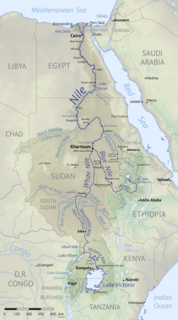
WThe geography of South Sudan describes the physical features of South Sudan, a country in East Africa. South Sudan is a landlocked country and borders – clockwise – Sudan from the north, Ethiopia from the east, Kenya, Uganda and the Democratic Republic of the Congo from the south and the Central African Republic from the west.
 W
WThe Bahr el Arab rift is a major geological feature in the southwest Sudan.
 W
WThe Central African Shear Zone (CASZ) is a wrench fault system extending in an ENE direction from the Gulf of Guinea through Cameroon into Sudan. The structure is not well understood. As of 2008, there was still no general agreement about how the individual shears along the lineament link up.
 W
WThe Congo-Nile Divide is the continental divide that separates the drainage basins of the Nile and Congo rivers. It is about 2,000 kilometres (1,200 mi) long.
 W
WThe Ironstone Plateau is a region in the south and west of South Sudan.
 W
WMukaya Payam is situated in Lainya County in central Equatoria State, South Sudan; It was a former local administrator head for current Yei river county. The name (Mukaya) originated from Hill located about in central of the Mukaya geographical land, which is around 9 to 12 miles north of Yei river County. The Mukaya differentiates into smaller clans of Dimo (1), Dimo (2), Dimo na Godo, Rume, Kendire, Goromba, Mingale, Jolobong, Pisak, Piyasuk, Bori, Yondoru, Sowaka, Ligi, Girim, Yensot, Migibura, Bono, Muresuku, Morsak, Gokoni, Malari, Worokusuk, Bujang, Mika, Warijang, Gori, Kobo, Nyori, Morsak, Bonga, Mikatom, Jubor, and a few other smaller ones. The population of the Mukaya Payam is estimated to be 15,000 persons.
 W
WThe Nile Basin is the part of Africa drained by the Nile River and its tributaries.
 W
WPacong is a town in South Sudan. The town is located just outside Rumbek on the road to Wulu.
 W
WSudan is the geographic region to the south of the Sahara, stretching from Western to eastern Central Africa. The name derives from the Arabic bilād as-sūdān, or "the lands of the Blacks", referring to West Africa and northern Central Africa. The Arabic name was translated as Negroland on older English maps.
 W
WThe Sudans is a region in Africa comprising the countries of South Sudan and the Sudan.