 W
WTanzania comprises many lakes, national parks, and Africa's highest point, Mount Kilimanjaro. Northeast Tanzania is mountainous, while the central area is part of a large plateau covered in grasslands. The country also contains the southern portion of Lake Victoria on its northern border with Uganda and Kenya.
 W
WThe Congo-Nile Divide is the continental divide that separates the drainage basins of the Nile and Congo rivers. It is about 2,000 kilometres (1,200 mi) long.
 W
WKimboza Forest is a lowland forest in Tanzania located at the foothills of the Uluguru Mountains 7°2′S 37°47′E. The large Ruvu River crosses the reserve and the forest stretches to the top of the nearby hills. It is interspersed by massive rock outcrops and has several permanent small streams.
 W
WKyaka is a town in Tanzania. It is an urban centre in Missenyi District, Kagera Region. The population of Kyaka was estimated at about 6,000 people in 2015.
 W
WMateruni Waterfall is one of the Waterfalls in the Mware River. It is found in the village of Materuni on the edge of the Kilimanjaro mountain reserve.
 W
WMrima or Mrima Coast is the traditional name for the part of the East African coast facing Zanzibar. The inhabitants were often called "Wamrima" or Mrima people even though they could belong to different tribes and language groups.
 W
WThe Mtwara–Mbamba Bay Road, also A19 Road, connects the city of Mtwara on the Indian Ocean coast, to the town of Mbamba Bay on the eastern coast of Lake Malawi. It is a busy and important transport corridor in the southern regions of Tanzania. It is also an integral part of the Mtwara Development Corridor that spans four Southern African countries; Malawi, Mozambique, Tanzania and Zambia.
 W
WUnyamwezi is a historical region in what is now Tanzania, around the modern city of Tabora to the south of Lake Victoria and east of Lake Tanganyika. It lay on the trade route from the coast to Lake Tanganyika and to the kingdoms to the west of Lake Victoria. The various peoples of the region were known as long-distance traders, providing porters for caravans and arranging caravans in their own right. At first the main trade was in ivory, but later slaving became more important.
 W
WUsangi - Northern Tanzania. Usangi is part of North Pare which consists of Usangi and Ugweno. Usangi is located between Ugweno in the north na Mgagao in Southern Pare, to the west it borders with Mwanga the current administrative headquarter of Mwanga District and to the east it faces the Tanzania border with Kenya. Usangi is located on the pare mountain ranges which builds up to the Kilimanjaro mountain to the north east. The Usangi Kingdom was ruled by Wasangi rulers - Wafumwa from Mfumwa Sangiwa Makoko who died in 1881 up to Mfumwa Shabani Mtengeti Sangiwa who ruled until 1962 when traditional rule was abolished following the independence of Tanganyika in 1961. The Kingdom was briefly ruled by Mfumwa Sabuni before the Wasangi reclaimed it and Mfumwa Shabani was crowned.
 W
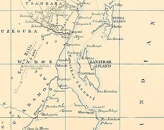
WThe Zanzibar Channel is a strait in south-eastern Africa, separating the island of Unguja from mainland Tanzania. The channel is 120 km long and 29-37 km wide, with depth varying from a few dozen metres to a few hundred metres to the north and to the south. In ancient times the overall depth of the channel has been considerably smaller.