 W
WThe Germany–Netherlands border consists of a land border that is 570 km (350 mi) long and a maritime border running from the bay through the Frisian Islands into the North Sea.
 W
WBargerveen Nature Reserve is a nature reserve in the Dutch province of Drenthe that has been included in the Natura 2000 ecological network. Since 2006 it is part of the Internationaler Naturpark Bourtanger Moor-Bargerveen, a nature reserve located on both sides of the border between the Netherlands and Germany. Most of the transboundary nature reserve, some 134 km2 (52 sq mi), lies in Germany, in the west of the state of Lower Saxony. The sparsely populated landscape consists of large peat areas, heather, and small lakes.
 W
WThe Dollart or Dollard is a bay in the Wadden Sea between the northern Netherlands and Germany, on the west side of the estuary of the Ems river. Most of it dries at low tide. Many water birds feed there.
 W
WAt the end of World War II, plans were made in the Netherlands to annex German territory as compensation for the damages caused by the war. In October 1945, the Dutch state asked Germany for 25 billion guilders in reparations. In February 1945 it had already been established at the Yalta Conference that reparations would not be given in monetary form. The plan which was worked out in most detail was the one made by Frits Bakker Schut, and hence became known as the Bakker-Schut Plan.
 W
WThe Ems is a river in northwestern Germany. It runs through the states of North Rhine-Westphalia and Lower Saxony, and discharges into the Dollart Bay which is part of the Wadden Sea. Its total length is 362.4 kilometres (225.2 mi). The state border between the Lower Saxon area of East Friesland (Germany) and the province of Groningen (Netherlands), whose exact course was the subject of a border dispute between Germany and the Netherlands, runs through the Ems estuary.
 W
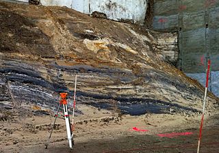
WThe Aachen Formation is a Late Cretaceous geologic formation in the southern Netherlands and northeastern Belgium and adjacent Germany.
 W
WGrenzaa or Schoonebeker Diep is a river on the border of Lower Saxony, Germany and Drenthe, Netherlands, near the town Twist. It forms some of the border between the Netherlands and Germany. Through the Coevorden-Piccardie-Kanal and the Coevorden-Vechtkanaal it discharges into the Vechte near Coevorden.
 W
WGermany v Denmark and the Netherlands [1969] ICJ 1 were a series of disputes that came to the International Court of Justice in 1969. They involved agreements among Denmark, Germany, and the Netherlands regarding the "delimitation" of areas—rich in oil and gas—of the continental shelf in the North Sea.
 W
WSelzerbeek is a river of North Rhine-Westphalia, Germany and Limburg in the Netherlands. It stretches over approximately 13 kilometres (8 mi) from its source at Aachen to its mouth near Gulpen into the Geul.
 W
WDie Wild is a small stream on the border between Germany and The Netherlands. If flows south of the Dutch town of 's-Heerenberg and the German village of Elten towards the north of the Dutch village of Spijk. North of Lobith it flows into the Oude Rijn, an old branch of the Rhine.