 W
WBing Maps is a web mapping service provided as a part of Microsoft's Bing suite of search engines and powered by the Bing Maps for Enterprise framework.
Bing Maps Platform is a geospatial mapping platform produced by Microsoft. It allows developers to create applications that layer location-relevant data on top of licensed map imagery. The imagery includes samples taken by satellite sensors, aerial cameras, Streetside imagery, 3D city models and terrain.
 W
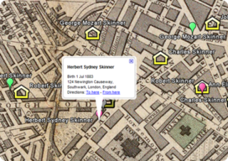
WFamily tree mapping is the process of geocoding places in family tree files to produce geospatial data suitable for viewing with a virtual globe or 2D mapping program.
Google Earth is a computer program, formerly known as Keyhole EarthViewer, that renders a 3D representation of Earth based primarily on satellite imagery. The program maps the Earth by superimposing satellite images, aerial photography, and GIS data onto a 3D globe, allowing users to see cities and landscapes from various angles. Users can explore the globe by entering addresses and coordinates, or by using a keyboard or mouse. The program can also be downloaded on a smartphone or tablet, using a touch screen or stylus to navigate. Users may use the program to add their own data using Keyhole Markup Language and upload them through various sources, such as forums or blogs. Google Earth is able to show various kinds of images overlaid on the surface of the earth and is also a Web Map Service client. Recently Google has revealed that Google Earth now covers more than 98 percent of the world, and has captured 10 million miles of Street View imagery, a distance that could circle the globe more than 400 times.
 W
WGoogle Maps is a web mapping service developed by Google. It offers satellite imagery, aerial photography, street maps, 360° interactive panoramic views of streets, real-time traffic conditions, and route planning for traveling by foot, car, bicycle, air and public transportation. In 2020, Google Maps was used by over 1 billion people every month.
 W
WMap My Ancestors is an application for converting GEDCOM files produced by genealogy software into Keyhole Markup Language (KML) files for viewing with KML-compatible programs such as Google Earth or Google Maps. It can also convert comma-separated values (CSV) files produced by spreadsheet or database software into KML files.
 W
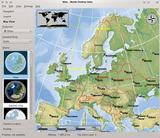
WMarble is a virtual globe application which allows the user to choose among the Earth, the Moon, Venus, Mars and other planets to display as a 3-D model. It is free software under the terms of the GNU LGPL, developed by KDE for use on personal computers and smart phones. It is written in C++ and uses Qt.
 W
WNASA WorldWind is an open-source virtual globe. It was first developed by NASA in 2003 for use on personal computers and then further developed in concert with the open source community since 2004. As of 2017, a web-based version of WorldWind is available online. An Android version is also available.
 W
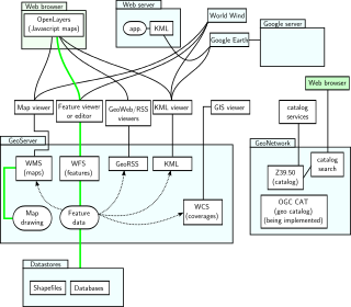
WOpenLayers is an open-source JavaScript library for displaying map data in web browsers as slippy maps. It provides an API for building rich web-based geographic applications similar to Google Maps and Bing Maps.
Yahoo! Pipes was a web application from Yahoo! that provided a graphical user interface for building data mashups that aggregate web feeds, web pages, and other services; creating Web-based apps from various sources; and publishing those apps. The application worked by enabling users to "pipe" information from different sources and then set up rules for how that content should be modified. Other than the pipe editing page, the website had a documentation page and a discussion page. The documentation page contained information about pipes including guides for the pipe editor and troubleshooting. The discussion page enabled users to discuss the pipes with other users.