 W
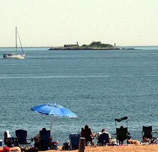
WHoffman Island is an 11-acre (4.5 ha) artificial island in the Lower New York Bay, off the South Beach of Staten Island, New York City. A smaller, 4-acre (1.6 ha) artificial island, Swinburne Island, lies immediately to the south. Created in 1873 upon the Orchard Shoal by the addition of landfill, the island is named for former New York City mayor (1866–1868) and New York Governor (1869–1871) John Thompson Hoffman.
 W
WIsle of Meadows is a 100-acre (0.40 km2) uninhabited island in the New York City borough of Staten Island in the United States. It is located along the western side of Staten Island, where Fresh Kills empties into the Arthur Kill. The island is owned by the city of New York. It is now a nature preserve providing important meadow and salt marsh nesting habitat for herons, ibises, and egrets, and is not open to the public.
 W
WMount Loretto Unique Area is an open space reserve and nature preserve administered by the New York State Department of Environmental Conservation on the South Shore of Staten Island, New York City. The area's total size is 241 acres (98 ha), of which 49 acres (20 ha) is underwater.
 W
WPrall's Island is an uninhabited island in the Arthur Kill between Staten Island, New York, and Linden, New Jersey, in the United States. The 89-acre (0.36 km2) island is one of the minor islands that are part of the borough of Staten Island in New York City.
 W
WThe Serpentine Ridge Nature Preserve is a 40 acres woodland in the North Shore of Staten Island between Howard Avenue at the top of the ridge and Van Duzer Street at the bottom of the hill. The Serpentine Ridge plays an important part in Staten Island's ecosystem and biodiversity and maintains significant geological features. The Serpentine Ridge is a steep terrain on the east shore of the island within the Grymes Hill and Silver Lake neighborhoods of Staten Island. The area is notable for its variety of ecosystems including wooded hillsides, glacial sinkholes, and bare serpentine rock. The area is part of Staten Island's Special Hillsides Preservation District. The district was established to preserve the hilly terrain and unique natural features of the region, by reducing hillside erosion, landslides, and excessive storm-water runoff. Most of its land remains in a natural state, thus the area is covered with native vegetation. The Serpentine Art and Nature Commons owns approximately 11.5 acres of land within the area and acts as an environmental steward to the entire area.
 W
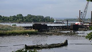
WShooters Island is a 43-acre (17 ha) uninhabited island at the southern end of Newark Bay, off the North Shore of Staten Island in New York City. The boundary between the states of New York and New Jersey runs through the island, with a small portion on the north end of the island belonging to the cities of Bayonne and Elizabeth in New Jersey and the rest being part of the borough of Staten Island in New York City.
 W
WThe Special Hillsides Preservation District was created in 1987 by the City of New York to preserve the hilly terrains of the North Shore of Staten Island. The district maintains different planning rules to the rest of the City to account for the geological and bio diversity of the area. The district's goals are to reduce hillside erosion, landslides, and excessive storm-water runoff by conserving vegetation and protecting natural terrain; preserve hillsides with unique aesthetic value; protect areas of outstanding natural beauty; and protect neighborhood character.
 W
WSwinburne Island is a 4-acre (1.6 ha) artificial island in the Lower New York Bay, off the South Beach of Staten Island, New York City. It was used for quarantine of immigrants. Swinburne Island is the smaller of two islands near South Beach, the other being Hoffman Island.
 W
WWard's Point is the southernmost point in the U.S. state of New York and lies within Tottenville, Staten Island, New York City. It is located at the mouth of Arthur Kill, across from Perth Amboy, New Jersey, at the head of Raritan Bay. The site is part of modern-day Conference House Park.
 W
WThe William T. Davis Wildlife Refuge (WTDWR) is an 814-acre (3.29 km2) wildlife refuge straddling the New Springville and Travis sections of Staten Island. The park was named in honor of Staten Island native William T. Davis, a renowned naturalist and entomologist who along with the Audubon Society started the refuge with an original acquisition of 52 acres (210,000 m2). Additional acreage was acquired in increments and the park is today 814 acres (3.29 km2). Beginning in 2010, the adjacent 223-acre (0.90 km2) North Park section of Freshkills Park has undergone preparation to serve as an expansion of the wildlife refuge.