 W
WAyyanakere is a lake near Sakharayapatna village of Karnataka, India and it is located at a distance of 18 kilometres (11 mi) from Chickmagalur. The lake is a major water source for agricultural activity for several villages up to a distance of 15 kilometres (9.3 mi). The lake has 10 canals to distribute water.
 W
WThe Bhadra River is a river in Karnataka state in southern India.
 W
WDattathreya Peeta is a mountain in range of the Western Ghats of India. Located in the Chikmagaluru taluk, Chikmagaluru District of Karnataka, Dattatreya peeta is known for its shrine to a pilgrimage site for Hindus .Sangh parivar organizations started "Datta Jayanti" celebrations in the late 2000s as part of their fight to claim "Sri Guru Dattatreya Swami Dattapit". People go to have a darshan of the dargah. The main peaks in this range are the Mullayanagiri and Baba Budangiri. Collectively, these peaks are known as Chandradrona Parvatha Shreni as they naturally form the shape of a crescent moon.
 W
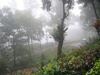
WHanumanagundi Falls, also known as Suthanabbe Falls or Soothanabbi Falls is located in the hilly surroundings of the Kudremukh National Park in the Chikkamagaluru district of Karnataka, India.
 W
WRiver Bhadra
 W
WKalhatti Falls or Kalahasti Falls is located at Tarikere taluk(kallathigiri) in Chikmagalur district of Karnataka, India. The waterfall is 10 kilometers (6.2 mi) away from Kemmangundi hill station.
 W
WKemmannugundi is a hill station in Tarikere taluk of Chikkamagaluru district in the state of Karnataka, India. It is 1434m above sea level. This was the summer retreat of Krishnaraja Wodeyar IV and as a mark of respect to the king, it is also known as Sri Krishnarajendra Hill Station. The station is ringed by the Baba Budan Giri Range, with cascades, mountain streams, and lush vegetation, Kemmangundi’s has ornamental gardens and mountains and valleys views. There is a spectacular sunset view from the Raj Bhavan.
 W
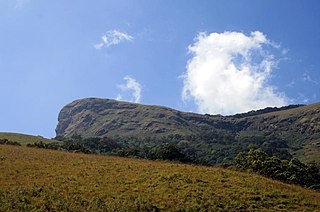
WKudremukha(ಕುದುರೆ ಮುಖ) is a mountain range and name of a peak located in Chikkamagaluru district, in Karnataka, India. It is also the name of a small hill station cum mining town situated near the mountain, about 20 kilometres from Kalasa. The name Kuduremukha literally means 'horse-face' (Kannada) and refers to a particular picturesque view of a side of the mountain that resembles a horse's face. It was also referred to as 'Samseparvata', historically since it was approached from Samse village. Kuduremukha is Karnataka's 2nd highest peak after Mullayanagiri. The nearest International Airport is at Mangalore which is at distance of 99 kilometres.
 W
WMullayanagiri is the highest peak in Karnataka, India. Mullayyanagiri is located at 13°23′26″N 75°43′18″E in the Chandra Dhrona Hill Ranges of the Western Ghats of Chikkamagaluru Taluk. With a height of 1,930 metres (6,330 ft), it is the highest peak in Karnataka. The summit of Mullayanagiri houses a police radio relay station. Seethalayyanagiri is a prominent peak is adjacent to this place.
 W
WThe Netravati River or Netravathi Nadi has its origins at Bangrabalige valley, Yelaneeru Ghat in Kudremukh in Chikkamagaluru district of Karnataka, India. This river flows through the famous pilgrimage place Dharmasthala and is considered as one of the Holy rivers of India. It merges with the Kumaradhara River at Uppinangadi before flowing to the Arabian Sea, south of Mangalore city. This river is the main source of water to Bantwal and Mangalore. The Netravati railway bridge is one of the known bridges which serve as the gateway to Mangalore.
 W
WSirimane Falls is one among the many waterfalls of the Western Ghats of Karnataka.