 W
WAralam Wildlife Sanctuary is the northernmost wildlife sanctuary of Kerala, southwest India. It is 55 km2 (21 sq mi) in area and located on the western slope of the Western Ghats. It was established in 1984. The headquarters of the sanctuary is near Iritty. Aralam Wildlife Sanctuary is situated in the southeast part of Kannur District. It lies between 11° 54′ and 11° 59′ north latitude and 75° 47′ and 75° 57′ east longitude.
 W
WAttappady Reserve Forest is a protected area comprising 249 km² of land covering the westernmost part of the 745 km² Attappady block of Mannarkkad Taluk in Palakkad district of Kerala, India. It is one of many reserved forests and protected forests of India.
 W
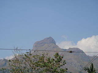
WElivai Mala is a 2,088-metre-tall (6,850 ft) peak in the Western Ghats of South India. The mountain lies in Palakkad district of Kerala, close to the border with Tamil Nadu. With a topographic prominence of 1,540 metres it is one of the ultra prominent peaks of South Asia. It forms the highest point in the Western Ghats to the immediate north of the Palakkad Gap. It is the highest peak in between Anamalai Hills and Nilgiri Hills in Western Ghats.
 W
WMalleswaran Mudi is the highest peak in the Attappadi Forest Reserve in Mannarkad Taluk, Palakkad district, Kerala, India at an elevation of 1,664 meters. It is located at the Agali Hills range in the Western Ghats.
 W
WNelliyampathy is a hill station 60 kilometres (37 mi) from Palakkad, state of Kerala, India.
 W
WThe Nilgiri Biosphere Reserve is an International Biosphere Reserve in the Western Ghats and Nilgiri Hills ranges of South India. The Nilgiri Sub-Cluster is a part of the Western Ghats, which was declared a World Heritage Site by UNESCO in 2012. It includes the Aralam, Mudumalai, Mukurthi, Nagarhole, Bandipur and Silent Valley national parks, as well as the Wayanad, Karimpuzha, and Sathyamangalam wildlife sanctuaries.
 W
WPadagiri, also known as Nellikota, is a hill in the Nelliyampathy Hills, in Chittur Taluk, Palakkad District, Kerala, and is the range's tallest peak, with an elevation of 1585m. It is around six kilometres from Nelliampathy. Nearby similar peaks are Vellichamudi, Valiyana, Velavanchan and Mayanmudi. The hill is particularly famed for its tall teak trees and the plantations featuring them..
 W
WPalakkad Gap or Palghat Gap is a low mountain pass in the Western Ghats between Coimbatore in Tamil Nadu and Palakkad in Kerala. It has an average elevation of 140 metres (460 ft) with a width of 24–30 kilometres (15–19 mi). The pass is located between the Nilgiri Hills to the north and Anaimalai Hills to the south.
 W
WParambikulam Tiger Reserve, which also includes the erstwhile Parambikulam Wildlife Sanctuary, is a 391 square kilometres (151.0 sq mi) protected area in Kollengode Block, Chittur taluk in Palakkad district of Kerala state, South India. The wildlife sanctuary, which had an area of 285 square kilometres (110 sq mi) was established in 1973. It is in the Sungam range of hills between the Anaimalai Hills and Nelliampathy Hills. Parambikulam Wildlife Sanctuary was declared as part of the Parambikulam Tiger Reserve on 19 February 2010. Including the buffer zone, the tiger reserve has a span of 643.66 km2. The Western Ghats, Anamalai Sub-Cluster, including all of Parambikulam Wildlife Sanctuary, is under consideration by the UNESCO World Heritage Committee for selection as a World Heritage Site. The sanctuary is the home of four different tribes of indigenous peoples including the Kadar, Malasar, Muduvar and Mala Malasar settled in six colonies. Parambikulam Tiger Reserve implements the Participatory Forest Management Scheme (PFMS). People from tribal colonies inside the reserve are engaged as guides for treks and safaris, and are provided employment through various eco-tourism initiatives. The tiger reserve hosts many capacity building training programmes conducted by Parambikulam Tiger Conservation Foundation in association with various organisations.
 W
WSilent Valley National Park, is a national park in Kerala, India. It is located in the Nilgiri hills, has a core area of 89.52 km2 (34.56 sq mi), which is surrounded by a buffer zone of 148 km2 (57 sq mi). This national park has some rare species of flora and fauna. This area was explored in 1847 by the botanist Robert Wight.
 W
WSispara, സിസ്പാര, a proper noun, is a combination of the Badaga language words si:su + pore; meaning: magnetite bearing rock + gorge. It may refer to:Sispara peak, a large hill in Kerala; Sispara bungalow, the shelter at the base of the peak; Sispara pass, the low gap between hills where the shelter is located; or Sispara ghat, the mountain trail that goes through the pass.