 W
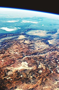
WThe Altiplano–Puna volcanic complex, also known as APVC, is a complex of volcanic systems in the Puna of the Andes. It is located in the Altiplano area, a highland bounded by the Bolivian Cordillera Real in the east and by the main chain of the Andes, the Western Cordillera, in the west. It results from the subduction of the Nazca Plate beneath the South American Plate. Melts caused by subduction have generated the volcanoes of the Andean Volcanic Belt including the APVC. The volcanic province is located between 21° S–24° S latitude. The APVC spans the countries of Argentina, Bolivia and Chile.
 W
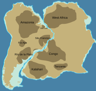
WThe Amazonian Craton is a geologic province located in South America. It occupies a large portion of the central, north and eastern part of the continent. The Guiana Shield and Central Brazil Shield constitutes respectively the northern and southern exhumed parts of the craton. Between the two shields lies the Amazon Rift, a zone of weakness within the craton. Smaller cratons of Precambrian rocks south of the Amazonian Shield are the Río de la Plata Craton and the São Francisco Craton, which lies to the east.
 W
WAndean Geology is a peer-reviewed scientific journal published three times per year by the National Geology and Mining Service, Chile's geology and mining agency. The journal covers the field of geology and related earth sciences, primarily on issues that are relevant to South America, Central America, and Antarctica with a particular focus on the Andes. The journal was established in 1974 and articles are published in English and Spanish. The editor-in-chief is Waldo Vivallo.
 W
WThe Andean orogeny is an ongoing process of orogeny that began in the Early Jurassic and is responsible for the rise of the Andes mountains. The orogeny is driven by a reactivation of a long-lived subduction system along the western margin of South America. On a continental scale the Cretaceous and Oligocene were periods of re-arrangements in the orogeny. Locally the details of the nature of the orogeny varies depending on the segment and the geological period considered.
 W
WThe Atlantic Shield is a large geological shield located in eastern South America. The shield is made up of the cratons of São Luís, São Francisco, Luís Alves and Río de la Plata.
 W
WGeological Observations on South America is a book written by the English naturalist Charles Darwin. The book was published in 1846, and is based on his travels during the second voyage of HMS Beagle, commanded by captain Robert FitzRoy. HMS Beagle arrived in South America to map out the coastlines and islands of the region for the British Navy. On the journey, Darwin collected fossils and plants, and recorded the continent's geological features.
 W
WThe geology of the Falkland Islands is described in several publications. The Falkland Islands are located on a projection of the Patagonian continental shelf. In ancient geological time this shelf was part of Gondwana, which around 400 million years ago broke from what is now Africa and drifted westwards relative to Africa. Studies of the seabed surrounding the islands indicated the possibility of oil. Intensive exploration began in 1996, although there had been some earlier seismic surveys in the region.
 W
WGondwana or Gondwanaland was a supercontinent that existed from the Neoproterozoic and began to break up during the Jurassic, with the opening of the Drake Passage, separating South America and Antarctica occurring during the Eocene. Gondwana was not considered a supercontinent by the earliest definition, since the landmasses of Baltica, Laurentia, and Siberia were separated from it.
 W
WThe Guiana Shield is one of the three cratons of the South American Plate. It is a 1.7 billion-year-old Precambrian geological formation in northeast South America that forms a portion of the northern coast. The higher elevations on the shield are called the Guiana Highlands, which is where the table-like mountains called tepuis are found. The Guiana Highlands are also the source of some of the world's most well-known waterfalls such as Angel Falls, Kaieteur Falls and Kuquenan Falls.
 W
WThe São Francisco Craton is an ancient craton in the eastern part of South America. The craton crops out in the Brazilian states of Minas Gerais and Bahia.
 W
WPatagonia comprises the southernmost region of South America, portions of which lie either side of the Chile–Argentina border. It has traditionally been described as the region south of the Rio Colorado, although the physiographic border has more recently been moved southward to the Huincul fault. The region's geologic border to the north is composed of the Rio de la Plata craton and several accreted terranes comprising the La Pampa province. The underlying basement rocks of the Patagonian region can be subdivided into two large massifs: the North Patagonian Massif and the Deseado Massif. These massifs are surrounded by sedimentary basins formed in the Mesozoic that underwent subsequent deformation during the Andean orogeny. Patagonia is known for their vast earthquakes and the damage.