 W
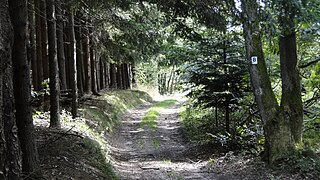
WThe Birkenhainer Straße is a long-distance hiking trail that follows an ancient trade route through the Mittelgebirge Spessart, in the states of Hesse and Bavaria, Germany. It is 71 km long and leads from Hanau to Gemünden am Main, cutting across the so-called Mainviereck, a large loop of the river Main. The trail follows an ancient trade route which in the Middle Ages was an important road for moving troops and for long-distance trade. The Birkenhainer Straße was a part of the link between Nuremberg and Antwerp. Its origins may lie back as far as the Neolithic period. The name likely derives from a prominent copse of birch trees that used to exist near the road at Geiselbach (Hesse).
 W
WThe Bishop's Road is and ancient road in Saxony, going from Meißen via Dresden to Stolpen.
 W
WThe Old and New Dresden to Teplitz Post Roads are passes over the Ore Mountains and form part of the well-known ancient road system known as the Kulmer Steig, which ran from the Elbe Valley near Dresden over the Eastern Ore Mountains to Teplitz, Bohemia. Today the Saxon section of the Old Dresden to Teplitz Post Road is the best preserved of these historic transport links, complete with old Electorate of Saxony postal milestones.
 W
WThe Eselsweg is a long-distance hiking trail that follows an ancient trade route through the Mittelgebirge Spessart, in the states of Hesse and Bavaria, Germany. It is 111 km long and leads from Schlüchtern in the valley of the Kinzig river to Großheubach on the river Main. The trail follows an ancient trade route on which donkey caravans used to transport salt, thus giving rise to the name.
 W
WIn the Middle Ages, Hellweg was the official and common name given to main travelling routes in Germany. Their breadth was decreed as an unimpeded passageway a lance's width, about three metres, which the landholders through which the Hellweg passed were required to maintain.
 W
WIn medieval times, imperial roads were designated routes in the Holy Roman Empire that afforded protection to travellers in return for tolls collected for the emperor.
 W
WThe Kulmer Steig is a synonym for the transport links from the Elbe valley over the eastern part of the Eastern Ore Mountains to Bohemian Chlumec u Chabařovic, hence the name which means "Kulm Trail". It is an ancient road system of partly derelict and unmetalled historic transport routes. These historic long-distance routes have been uncovered today thanks to archaeological discoveries. The routes all head south from the Elbe valley between Dresden and Pirna and cross the Eastern Ore Mountains over mountain passes on the Saxon side between Fürstenwalde in the west and Oelsen in the east. The lowest crossings are located near Mohelnice from where they continue via Habartice and the Geiersberg as well as Krasný Les and further on over the Nollendorf Pass to Chlumec. The Kulmer Steig was an especially good transport route because the road cut a passage through untamed wilderness and 30 kilometres could be covered in a day.
 W
WThe Old Freiburg to Teplitz Post Road is one of the passes over the Ore Mountains and was a major transport link from the mining town of Freiberg (Saxony) over the crest of the Eastern Ore Mountains to the North Bohemian spa resort of Teplitz, now Teplice.
 W
WThe Ore Mountain passes are crossings and passages over the crest of the Ore Mountains in Central Europe, over which tracks, roads, railway lines and pipelines run from the Free State of Saxony in the Federal Republic of Germany to Bohemia in the Czech Republic and vice versa.
 W
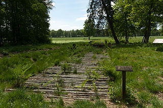
WThe Wittemoor timber trackway is a log causeway or corduroy road across a bog at Neuenhuntdorf, part of the Berne in the district of Wesermarsch in Lower Saxony, Germany. Originating in the pre-Roman Iron Age, it is one of several such causeways which have been found in the North German Plain, particularly in the Weser-Ems region. It was excavated in 1965 and 1970 and prehistoric wooden cult figurines were discovered in association with it. It is trackway number XLII (IP).
 W
WThe Wittmoor bog trackway is the name given to each of two historic corduroy roads, trackway No. I being discovered in 1898 and trackway No. II in 1904 in the Wittmoor bog in northern Hamburg, Germany. The trackways date to the 4th and 7th century AD, both linked the eastern and western shores of the formerly inaccessible, swampy bog. A part of the older trackway No. II dating to the period of the Roman Empire is on display at the permanent exhibition of the Archaeological Museum Hamburg in Harburg, Hamburg.