 W
WThe Arawale National Reserve is a designated conservation area managed by the Garissa County in assistance with the Kenya Wildlife Service. It lies in North Eastern Province of Kenya, 77 km south of the town of Garissa. The reserve covers an area of 53,324 hectares. To the west, it is bordered by the Tana River and, to the east, by the Garissa-Lamu road. In 1974, the reserve was gazetted as the only in-situ conservation site for the critically endangered Hirola population endemic to north-eastern Kenya and south-west Somalia.
 W
WBuffalo Springs National Reserve is a protected area in the Isiolo County in northern Kenya.
 W
WKakamega Forest is a tropical rainforest situated in the Kakamega and Nandi County of Kenya, northwest of the capital Nairobi, and near to the border with Uganda. It is Kenya's only tropical rainforest and is said to be Kenya's last remnant of the ancient Guineo-Congolian rainforest that once spanned the continent.
 W
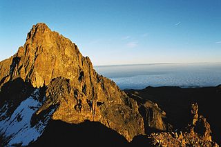
WMount Kenya is the highest mountain in Kenya and the second-highest in Africa, after Kilimanjaro. The highest peaks of the mountain are Batian, Nelion and Point Lenana. Mount Kenya is located in the former Eastern and Central provinces of Kenya, now Meru, Embu, Laikipia, Kirinyaga, Nyeri and Tharaka Nithi counties, about 16.5 kilometres south of the equator, around 150 km (90 mi) north-northeast of the capital Nairobi. Mount Kenya is the source of the name of the Republic of Kenya.
 W
WLake Bogoria National Reserve is in the Great Rift Valley, Kenya, covering Lake Bogoria and the land immediately surrounding the lake. It is administered by the Kenya Wildlife Service.
WMaasai Mara, also sometimes spelled Masai Mara and locally known simply as The Mara, is a large national game reserve in Narok, Kenya, contiguous with the Serengeti National Park in Tanzania. It is named in honor of the Maasai people, the ancestral inhabitants of the area, who migrated to the area from the Nile Basin. Their description of the area when looked at from afar: "Mara" means "spotted" in the local Maasai language, due to the many short bushy trees which dot the landscape.
 W
WThe Mwea National Reserve is a nature reserve in Kenya. It’s altitude ranges between 1,000 - 1,100 m, dominated by the Acacia-Commiphora bushland on the north shore of Kamburu Reservoir, at the confluence of Tana and Thiba Rivers. The other vegetation is mixed among the scattered large trees, typical savannah ecosystem. Open grasslands are dominant along the main rivers, with occasional thick undergrowth, as well as a riparian or riverine woodland.
 W
WThe Samburu National Reserve is a game reserve on the banks of the Ewaso Ng'iro river in Kenya. On the other side of the river is the Buffalo Springs National Reserve. The park is 165 km² in size and is situated 350 kilometers from Nairobi. It ranges in altitude from 800 to 1230m above sea level. Geographically, it is located in Samburu County.
 W
WShaba National Reserve is a protected area in Isiolo County in northern Kenya to the east of the Samburu and Buffalo Springs national reserves. Together, the three reserves form a large protected area.
WThe Shimba Hills National Reserve is a small National Reserve in the Coast Province of Kenya, 33 km from Mombasa and 15 km from the coast. The reserve is an area of coastal rainforest, woodland and grassland. It is an important area for plant biodiversity – over 50% of the 159 rare plants in Kenya are found in the Shimba Hills, including some endangered species of cycad and orchids. It is also a nationally important site for birds and butterflies.
WThe Witu Forest, is a protected area in Lamu District, Kenya, East Africa. It was formed in 1927 by combining the Utwani Forest Reserve with the adjacent Gongoni Forest Reserve, although the previous names remained in use. The independent Kenyan government confirmed the reservation, gazetting the forest in 1962, with 701 hectares more gazetted in 2002. The forest covers 4,639 hectares of gazetted land, with approximately 900 hectares of additional un gazetted, but enclosed, forest. The adjacent Mungajini Forest on the Nairobi Ranch contains approximately 1,100 hectares. As of 2007, there was no management plan for the forest, although it is to be managed under the Forests Act, 2005, by the Kenya Forest Service (KFS) which replaced the prior Forest Department in 2005.