 W
WA world map is a map of most or all of the surface of Earth. World maps, because of their scale, must deal with the problem of projection. Maps rendered in two dimensions by necessity distort the display of the three-dimensional surface of the earth. While this is true of any map, these distortions reach extremes in a world map. Many techniques have been developed to present world maps which address diverse technical and aesthetic goals.
 W
WThe Genoese map is a 1457 world map. The map relied extensively on the account of the traveler to Asia Niccolo da Conti, rather than the usual source of Marco Polo. The author is not known, but is a more modern development than the Fra Mauro world map, with fairly good proportions given to each continents. The map also depicts a three-masted European ship in the Indian Ocean, something which had not occurred yet at the time.
 W
WThe World Map at Lake Klejtrup is a miniature world map built of stones and grass in Klejtrup Sø near the village of Klejtrup, Viborg Municipality, Denmark.
 W
WThe Kunyu Quantu, or Full Map of the World, was a map of the world developed by Jesuit father Ferdinand Verbiest during his mission in China in 1674. A copy is in the Hunterian Museum.
 W
WThe Outline of the Post-War New World Map was a map completed before the attack on Pearl Harbor and self-published on February 25, 1942 by Maurice Gomberg of Philadelphia, United States. It shows a proposed political division of the world after World War II in the event of an Allied victory in which the United States of America, the United Kingdom, and the Soviet Union as well as the Republic of China would rule. The map includes a manifesto describing a "New World Moral Order", along with quotes from Roosevelt's Four Freedoms speech.
 W
WThe Valeriepieris circle is a South China Sea-centered circular region on the world map that is about 4,000 kilometers (2,500 mi) in radius and contains more than half the world’s population. It was named after the Reddit username of Ken Myers, a Texas ESL teacher, who first drew attention to the phenomenon in 2013. The map became a meme and was featured in numerous forms of media.
 W
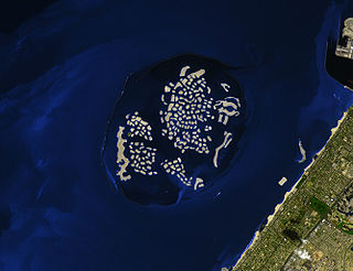
WThe World or The World Islands, is an archipelago of small artificial islands constructed in the shape of a world map, located in the waters of the Persian Gulf, 4.0 kilometres (2.5 mi) off the coast of Dubai, United Arab Emirates. The World islands are composed mainly of sand dredged from Dubai's shallow coastal waters, and are one of several artificial island developments in Dubai. The World's developer is Nakheel Properties, and the project was originally conceived by Sheikh Mohammed bin Rashid Al Maktoum, the ruler of Dubai. The construction was done by two Dutch specialist companies, Van Oord and Boskalis. The same companies also created the Palm Jumeirah.
 W
WA World Aeronautical Chart (WAC) is a type of aeronautical chart used for navigation by pilots of moderate speed aircraft and aircraft at high altitudes. They are at a scale of 1:1,000,000.
 W
WThe World Map 1:2,500,000 is an internationally standardized and edited map series. The term Карта Мира or in transcription Karta Mira is now commonly used to describe this series, even outside the Soviet Union or Russia. The Karta Mira consists of a total of 224 main sheets and 38 overlap sheets. They depict the entire earth according to a uniform scale, coloring and drawing system. The Karta Mira 1956-1975 was produced by cartographers from Bulgaria, Czechoslovakia, the German Democratic Republic, Hungary, Poland, Romania and the Soviet Union.
 W
W W
W