 W
WAbbot's Meads is a suburb of Chester in Cheshire, England. Abbot's Meads is north-west of Chester city centre. The Countess of Chester Hospital is nearby. The population as taken in the 2011 census can be found under Chester.
 W
WBoughton is a neighbourhood to the east of Chester city centre, part of the unitary authority of Cheshire West and Chester and the ceremonial county of Cheshire, England. It is located atop the steep banks of the River Dee as it turns the meadows bend for the last time around the 'Earls Eye' before flowing into Chester.
 W
WCurzon Park is an upmarket residential suburb of Chester, Cheshire in England. The area, which adjoins the southern banks of the Dee, was first laid out in the 19th century. It is situated next to the Grosvenor Bridge and is well known for having some of the city's largest and most prestigious residences.
 W
WHandbridge is a district of Chester, England on the south bank of the River Dee. A settlement has existed on the site since the Iron Age, but the site saw major expansion during the collapse of the Roman occupation of Britain, as the city grew too large for its walls. The site was originally mainly a quarry for the abundant red sandstone that much Chester is built from, but in later years became a centre for salmon fishing in the Dee.
 W
WHoole is a suburb in the east of Chester, in the unitary authority of Cheshire West and Chester and the ceremonial county of Cheshire, England.
 W
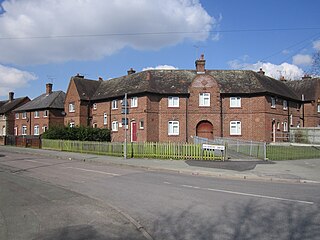
WThe Lache is a housing estate in the city of Chester, in Cheshire, United Kingdom, with a population of around 10,000. It is located approximately 2 miles (3 km) southwest of the ancient city, with good local transport links en route to Saltney. The main streets are Cliveden Road, which runs through the centre of the estate, and Sycamore Drive. The area runs almost continuously into Westminster Park and Saltney.
 W
WMollington is a small village and civil parish in the unitary authority of Cheshire West and Chester and the ceremonial county of Cheshire, England. It is located two miles north of the city of Chester, with approximate boundaries formed by the A41 Liverpool-Chester trunk road and Shropshire Union Canal to the east and southeast, the A540 Wirral Peninsula trunk road to the south and west and the A5117 Dunkirk link road to the north.
WNewton is a suburb in the north-east of Chester, in the unitary authority of Cheshire West and Chester and the ceremonial county of Cheshire, England. Including the locale of Plas Newton, the area is contiguous with Upton to the north and Hoole to the south. The electoral ward involved had a population taken at the 2011 census was 9,556.
WQueens Park is a suburb of Chester. It is in the south of the city, just east of Handbridge. It includes a secondary school, Queens Park High School and also has a pedestrian suspension bridge link with the main city.
 W
WSaltney is a town and community adjoining Chester on the England–Wales border with the west part lying in Flintshire and the eastern part in Cheshire. It is part of the Deeside conurbation of towns that lie near the River Dee.
 W
WVicars Cross is a large suburban area situated on the east side of Chester, in Cheshire, England. At the 2001 Census the area had a population of 5,663..
 W
WWestminster Park is both a suburb to the west of Chester in England, and a large park the area takes its name after. Chester residents do not consider the area as a part of the Lache although the main route through Westminster Park is Lache Lane. In any case it can sometimes be difficult to tell where one suburb ends and another begins.