 W
WThe geography of Finland is characterized by its northern position, its ubiquitous landscapes of intermingled boreal forests and lakes, and its low population density. Finland can be divided into three areas: archipelagoes and coastal lowlands, a slightly higher central lake plateau and uplands to north and northeast. Bordering the Baltic Sea, Gulf of Bothnia, and Gulf of Finland, as well as Sweden, Norway, and Russia, Finland is the northernmost country in the European Union. Most of the population and agricultural resources are concentrated in the south. Northern and eastern Finland are sparsely populated containing vast wilderness areas. Taiga forest is the dominant vegetation type.
 W
WThe Baltoscandian Confederation or Baltoscandia is a geopolitical concept of a Baltic–Scandinavian union. The idea was proposed by a Swedish professor Sten de Geer (1886–1933) in the journal Geografiska Annaler in 1928 and further developed by Professor Kazys Pakštas (1893–1960), a Lithuanian scientist in the field of geography and geopolitics.
 W
WThe Barents Region is a name given, by advocates of establishing international cooperation after the fall of the Soviet Union, to the land along the coast of the Barents Sea, from Nordland in Norway to the Kola Peninsula in Russia and beyond all the way to the Ural Mountains and Novaya Zemlya, and south to the Gulf of Bothnia of the Baltic Sea and the great lakes Ladoga and Onega. Among the projects is the Barents Road from Bodø in Norway through Haparanda in Sweden and Finland to Murmansk in Russia. One concrete sign of the increased communication within the region is the establishment in 2006 of an IKEA store in Haparanda (Sweden), targeting customers 500 km away in Murmansk and northern Norway. The region has six million inhabitants on 1.75 million km2; three quarters of both belong to Russia.
 W
WThe Cap of the North consists of the counties Troms og Finnmark and Nordland in Norway, Norrbotten County in Sweden, Lapland/Lappi Region in Finland and Murmansk Oblast in Russia.
 W
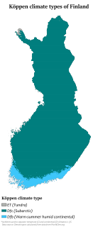
WThe climate of Finland is influenced most by its latitude: Finland is located between 60 and 70 N. Because of Finland's northern location, winter is the longest season. Only on the south coast and the southwest is summer as long as winter. On average, winter lasts from early January to late February in the outermost islands in the archipelago and the warmest locations along the southwestern coast – notably in Hanko, and from early October to mid May in the most elevated locations, such as northwestern Lapland and the lowest valleys in northeastern Lapland. This means that southern portions of the country are snow-covered about three to four months of the year, and the northern for about seven months. The long winter causes about half of the annual 500 to 600 millimetres precipitation in the north to fall as snow. Precipitation in the south amounts to about 600 to 700 millimetres annually. Like that of the north, it occurs all through the year, though not so much of it is snow.
 W
WItä-Häme is the eastern part of the historical province Tavastia in Finland. It is in Päijänne Tavastia, Southern Savonia and Central Finland.
The National Land Survey of Finland is an official body, dealing with cartography and cadastre issues in Finland. It is subordinated the Finnish Ministry of Agriculture and Forestry.
 W
WThe Norwegian Barents Secretariat aims at developing the Norwegian-Russian relations in the north by promoting and funding Norwegian-Russian cooperation projects. On behalf of the Norwegian Ministry of Foreign Affairs, the Secretariat grant funds to bilateral Norwegian-Russian cooperation projects. The Secretariat grants approximately 200 Norwegian-Russian projects annually.
 W
WSápmi is the cultural region traditionally inhabited by the Sámi people. Sápmi is in Northern Europe and includes the northern parts of Fennoscandia.
 W
WThe subarctic zone is a region in the Northern Hemisphere immediately south of the true Arctic and covering much of Alaska, Canada, Iceland, the north of Scandinavia, Siberia, the Shetland Islands, and the Cairngorms. Generally, subarctic regions fall between 50°N and 70°N latitude, depending on local climates. Precipitation is low, and vegetation is characteristic of the taiga.
 W
WSvenskfinland is the common name for the areas in Finland where the majority of the Swedish-speaking population of Finland live. The Finland-Swedish information and cultural centre Luckan upholds a website featuring information about Finland's Swedish speaking minority in English; Svenskfinland.fi
 W
WAn urban area in Finland is defined as an inhabited area of at least 200 people and a maximum distance of 200 metres (660 ft) between buildings. The Finnish term for this is a taajama. Because of the strict definition of a taajama, these areas exist both inside and outside of city and municipal borders.