 W
WPeru is a country on the central western coast of South America facing the Pacific Ocean. It lies wholly in the Southern Hemisphere, its northernmost extreme reaching to 1.8 minutes of latitude or about 3.3 kilometres (2.1 mi) south of the equator. Peru shares land borders with Ecuador, Colombia, Brazil, Bolivia, and Chile, with its longest land border shared with Brazil.
 W
WAn andén, Spanish for "platform", is a stair-step like terrace dug into the slope of a hillside for agricultural purposes. The term is most often used to refer to the terraces built by pre-Columbian cultures in the Andes mountains of South America. Andenes had several functions, the most important of which was to increase the amount of cultivatable land available to farmers by leveling a planting area for crops. The best known examples of andenes are in Peru, especially in the Sacred Valley near the Inca capital of Cuzco and in the Colca Canyon. Many andenes have survived for more than 500 years and are still in use by farmers throughout the region.
 W
WClimate of Peru describes the diverse climates of this large South American country with an area of 1,285,216 km2 (496,225 sq mi). Peru is located entirely in the tropics but features desert and mountain climates as well as tropical rain forests. Elevations above sea level in the country range from −37 metres (−121 ft) to 6,788 metres (22,270 ft) and precipitation ranges from less than 20 millimetres (0.79 in) annually to more than 8,000 millimetres (310 in). There are three main climatic regions: the Pacific Ocean coast is one of the driest deserts in the world but with some unique features; the high Andes mountains have a variety of microclimates depending on elevation and exposure and with temperatures and precipitation from temperate to polar and wet to dry; and the Amazon Basin has tropical climates, mostly with abundant precipitation, along with sub-tropical climates in elevations above 1,550 metres (5,090 ft).
 W
WGarúa is a Spanish word meaning drizzle or mist. Although used in other contexts in the Spanish-speaking world, garúa most importantly refers to the moist cold fog that blankets the coasts of Peru, southern Ecuador, and northern Chile, especially during the southern hemisphere winter. Garúa is called Camanchaca in Chile. Garúa brings mild temperatures and high humidity to a tropical coastal desert. It also provides moisture from fog and mist to a nearly-rainless region and permits the existence of vegetated fog oases, called lomas.
 W
WThe Gran Pajonal is an isolated interfluvial plateau in the Amazon Basin of Peru. It is located in the departments of Ucayali, Pasco and Junín. The plateau is inhabited by the Asháninka or Ashéninka people along with late-twentieth century immigrants largely from the Andes mountains of Peru. In the 1730s, Roman Catholic Franciscan missionaries established missions in the Gran Pajonal, but the missions were destroyed in the 1740s by the Ashaninka under the leadership of Juan Santos Atahualpa.
 W
WThe North macroregion in Peru is a geographic area that includes a number of regions located in northern the country. It consists of the regions of Tumbes, Piura, Lambayeque, La Libertad, Cajamarca, San Martín, Amazonas and Ancash.
 W
WPampa Grande is an archaeological site located in the Lambayeque Valley, in northern Peru, situated on the south shore of the Chancay River. It is located to the east of the city of Chiclayo.
 W
WParatoari is a site composed of pyramid-shaped natural formations in the Manu area of dense tropical rainforest in southeast Peru. It was first identified via NASA satellite photograph number C-S11-32W071-03, released in 1976. They subsequently garnered greater attention among South America aficionados through a series of three articles which questioned from afar what "The Dots" might truly represent in 1977 - 1979 issues of the "South American Explorer" journal, written under the name of "Ursula Thiermann" by Don Montague, president of the South American Explorers Club.
 W
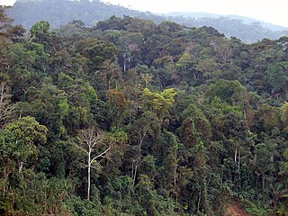
WPeruvian Amazonia is the area of the Amazon rainforest included within the country of Peru, from east of the Andes to the borders with Ecuador, Colombia, Brazil and Bolivia. This region comprises 60% of the country and is marked by a large degree of biodiversity. Peru has the second-largest portion of the Amazon rainforest after the Brazilian Amazon.
 W
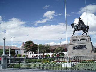
WThe Plaza de Armas of Ayacucho is in the city center of Ayacucho, Peru. Central plazas in Peru are typically called the Plaza Mayor. The Plaza de Armas is so named because it was the place where the city's defenders assembled during emergencies. In Ayacucho it is known as Sucre Park.
 W
WPozuzo is a village and district in the Oxapampa Province and Pasco Region of Peru. The village, at an elevation of 739 metres (2,425 ft), is situated near the left bank of the Huancabamba River which is renamed the Pozuzo River after it passes by the village. The population of the village in 2017 was 1,366. Pozuzo was established in 1859 by Austrian and German immigrants to Peru and traces of German culture and architecture survived into the 21st century. Pozuzo was isolated and difficult to access until 1976 when a vehicle road was completed linking the village with the town of Oxapampa, 80 kilometres (50 mi) north.
 W
WThe Valle de los Ríos Apurímac, Ene y Mantaro, also known as the VRAEM or VRAE, is a geopolitical area in Peru. It is one of the major areas of coca-growing in Peru. The area is extremely poor.