 W
WBullarebygden is the name of the area surrounding three connected lakes in Bohuslän in the southwestern part of Sweden. Another commonly used name for the same area is Bullaren. The landscape is a mixture of forests and meadows. Less than 2,000 people populate the rural area and by tradition farming is still common. Moose hunting and fishing are popular activities, both by people living there and by visitors. Bullaren is known for the annual bicycle race called "Bullingrutten" which is much like a huge feast for the locals, since no one is actually trying to win the actual race. The race takes the competitors around the center lake, while the nature at the same time brings beautiful views. Other events that take place is the annual market, as well as a live show made by "Bullingen Jär´et igen" at the local rustic site.
 W
WDjurö is an island, a surrounding archipelago of some 30 islands, and a national park situated in Sweden's biggest lake, Vänern. Established in 1991, the national park has an area of 24 km2 (9.3 sq mi), and includes all the islands of the archipelago.
 W
WFalbygden is a geographical area, centered at the town of Falköping in Västergötland, in southwestern Sweden, and covered mostly by farmland. Most of the area belongs to Falköping Municipality and the west part of Tidaholm Municipality. In mediaeval times the area belonged to the hundreds Frökind, Gudhem, Vartofta, and Vilske. It is known for its geology, flora and megalithic culture.
 W
WThe Greby grave field is an Iron Age grave field in western Sweden. It is located north of Grebbestad, Tanum Municipality in Västra Götaland County. With its 220 graves, it is the largest site of this kind in Bohuslän.
 W
WHindens rev is a long, narrow, straight peninsula that projects westwards from Kålland into Dalbosjön, the western part of lake Vänern. Hindens rev is a terminal moraine and is part of what is known as the central Swedish terminal moraine zone. The latter is in turn part of a series of terminal moraines that runs from southern Norway through Dalsland, Skaraborg and Östergötland, continuing under the Baltic Sea into southern Finland and Russia as the Salpausselkä moraine which separates lakes Ladoga and Saimaa. These moraines were formed during the Younger Dryas period, about 11,000 years ago, when the ice cap from the last ice age temporarily ceased withdrawing and rocks and other glacial materials emerged from the melting ice were deposited in front of the glacier terminus.
 W
WThe Kattsund-Koster dyke swarm is a collection of dykes of Mesoproterozoic age in southeastern Norway and the West Coast of Sweden. The most prominent outcrops are in the Koster Islands in Sweden and Kattsund in Norway, hence the name. The dykes are made up of tholeiitic diabase and some dykes of intermediate composition. Some dykes are deformed and metamorphosed into amphibolite. Radiometric dating has shown that the dyke swarm is about 1421 million years old. Geologists have suggested that the dyke swarm is related to extensional tectonics.
 W
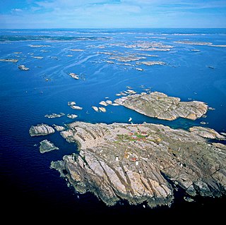
WKosterhavet National Park is the first national marine park in Sweden, inaugurated on September 2009. It is part of the Skagerrak sea and is located in Strömstad and Tanum municipalities in Bohuslän, Västra Götaland County, Sweden. It consists of the sea and shores around the Koster Islands, excluding everything else on the islands. In the north, it borders the Norwegian marine park of Ytre Hvaler.
 W
WThe Protogine Zone is a geological boundary zone in western Sweden. There are two slightly different definitions of the Protogine Zone. In the lithological definition it forms the limit between the gneisses of western Sweden and the relatively underformed eastern granites. As such it makes up the limit of deformation and metamorphism attributed to the Sveconorwegian orogeny. In the tectonic definition it is a zone of strong deformation that follows roughly the same course as the lithological Protogine Zone. In the two definitions of the Protogine Zone it runs from Scania across Lake Vättern into the upper course of Klarälven and then into Norway. The tectonic Protogine Zone has anastomosing branches and splits south of Lake Vättern into various diverging arms. The two westernmost of these arms follow the valleys of the Nissan and Lagan rivers. A more eastern branch is reflected in the alignment of the lakes Rusken, Rymmen and Möckeln.
 W
WSeglora is the most rural part of the Borås Municipality. It is bordering to Mark Municipality and Bollebygd Municipality in western Sweden.
 W
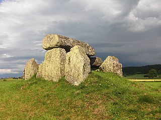
WStenehed is an Iron Age grave field located about 1 km southwest of Hällevadsholm, Munkedal Municipality, Västra Götaland County, Sweden. The area contains about 45 graves, a stone circle, a stone ship, and a row of menhirs.
 W
WTiveden is a long and wide densely forested rocky ridge in Sweden, throughout history notorious for its wilderness and dangers; historically a hiding place for outlaws. In historic times it, along with Tylöskog and Kolmården, formed the border between the land of the Swedes and the land of the Geats.
 W
WTresticklan National Park is located in the municipality of Dals-Ed in northwestern Dalsland, Sweden, along the Norwegian border. "Trestickel" means "trident", possibly a reference to the shape of Lake Stora Tresticklan. This national park contains one of the few remaining areas of old-growth forest in southern Scandinavia. The park was established in 1996 and has an area of 28.97 km2 (11.19 sq mi). The park's highest point is the Orshöjden.