 W
WThe geology of Pakistan encompasses the varied landscapes that make up the land constituting modern-day Pakistan, which are a blend of its geological history, and its climate over the past few million years.
 W
W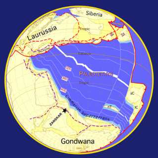 W
WThe geology of the Himalaya is a record of the most dramatic and visible creations of modern plate tectonic forces. The Himalayas, which stretch over 2400 km between the Namcha Barwa syntaxis in Tibet and the Nanga Parbat syntaxis in Kashmir, are the result of an ongoing orogeny — the result of a collision of the continental crust of two tectonic plates. This immense mountain range was formed by tectonic forces and sculpted by weathering and erosion. The Himalaya-Tibet region supplies fresh water for more than one-fifth of the world population, and accounts for a quarter of the global sedimentary budget. Topographically, the belt has many superlatives: the highest rate of uplift, the highest relief, among the highest erosion rates at 2–12 mm/yr, the source of some of the greatest rivers and the highest concentration of glaciers outside of the polar regions. This last feature earned the Himalaya its name, originating from the Sanskrit for "the abode of the snow".
 W
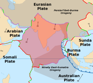
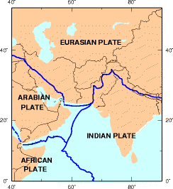
WThe Indian Plate or India Plate is a minor tectonic plate straddling the Equator in the Eastern Hemisphere. Originally a part of the ancient continent of Gondwana, India broke away from the other fragments of Gondwana 100 million years ago and began moving north. Once fused with the adjacent Australia to form a single Indo-Australian Plate, recent studies suggest that India and Australia have been separate plates for at least 3 million years and likely longer. The Indian Plate includes most of South Asia—i.e. the Indian subcontinent—and a portion of the basin under the Indian Ocean, including parts of South China and western Indonesia, and extending up to but not including Ladakh, Kohistan and Balochistan.
 W
WThe Iranian Plate is a small tectonic plate thought to underlie Iran and Afghanistan, and parts of Iraq and Pakistan.
 W
WThe Main Frontal Thrust (MFT), also known as the Himalayan Frontal Thrust (HFT) is a geological fault in the Himalayas
 W
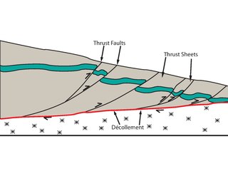
WThe Main Himalayan Thrust (MHT) is a décollement under the Himalaya Range. This thrust fault follows a NW-SE strike, reminiscent of an arc, and gently dip towards the north, beneath the region. It is the largest active continental megathrust fault in the world.
 W
WThe Makran Trench is the physiographic expression of a subduction zone along the northeastern margin of the Gulf of Oman adjacent to the southwestern coast of Balochistan of Pakistan and the southeastern coast of Iran. In this region the oceanic crust of the Arabian Plate is being subducted beneath the continental crust of the Eurasian Plate.
 W
WThe offshore Indus Basin is one of the two basins in offshore Pakistan, the other one being the offshore Makran Basin. The Murray Ridge separates the two basins. The offshore Indus basin is approximately 120 to 140 kilometers wide and has an areal extent of ~20,000 square km.
Geological Survey of Pakistan is a Pakistani state agency to explore the natural resources of Pakistan. Main tasks GSP perform are Geological, Geophysical and Geo-chemical Mapping of Pakistan. Target of these mapping are resources exploration, Geo-Engineering assessment, Geo-hazard prediction/prevention and addressing environmental issue.
 W
WPre-collisional Himalaya is a term describing the arrangement of the Himalayan rock units before the mountain-building process resulted from the collision between the continents of Asia and India. The collision began in the Cenozoic and it is a type locality of a continental-continental collision. The reconstruction of the initial configuration of the rock units and the relationship between them is highly controversial, and major concerns relate to the arrangements of the different rock units in three dimensions. Several models have been advanced to explain the possible arrangements and petrogenesis of the rock units.
WThe Rawat Fault is a geological fault in Pakistan. It runs through Punjab, from Rawat, Islamabad to Kashmir. The collision of the Eurasian Plate and the Indian Plate created the Himalaya Salt Range and the Rawat Fault, a line of boulders that the English deputy commissioner of Rawalpindi referred to in the Rawalpindi Gazetteer of 1893–94 as "dogs' teeth".