 W
WA National Wildlife Area is a conservation status for a geographical region in Canada that restricts most human activities on that region. However, land use permits may be issued "for activities that are compatible with conservation". Such areas are established and managed by the Canadian Wildlife Service, a division of Environment and Climate Change Canada. They may consist of land and water features, as well as coastal areas extending up to 12 nautical miles (22 km) from shore.
WThe Alaksen National Wildlife Area is located on Westham Island in the city of Delta, British Columbia. It is an important stopover point for many species of birds migrating along the Pacific Flyway.
 W
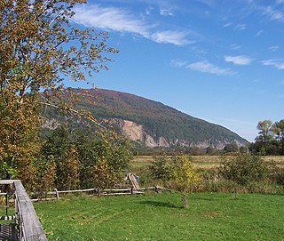
WThe Cap Tourmente National Wildlife Area is a National Wildlife Area located on the north shore of the Saint Lawrence River in the National Provincial Capital Region of Quebec, established on 28 April 1978. It is one of the critical habitats for the greater snow goose during migration. Flocks of tens of thousands of these birds stop over to feed on the bullrushes in the spring and fall. The tidal marsh was recognized as a wetland of international significance per the Ramsar Convention in 1981, the first North American site to receive that distinction.
 W
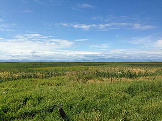
WColumbia National Wildlife Area is a national wildlife area in British Columbia, Canada. It was established in 1978 by the Canadian Wildlife Service to protect critical wetland habitat for migratory birds.
 W
WMohawk Island is a small island in Lake Erie, in the province of Ontario, Canada. It was formerly known as Gull Island. The island contains the ruins of the Gull Island Lighthouse, built in 1848 to guide ships into the Welland Canal. It was automated in 1933, and decommissioned in 1969. It is located close to the shore of Rock Point Provincial Park. The lantern room and stairs inside the lighthouse were removed, and the wood roof, the lighthouse keeper, door and windows are missing.
 W
WNirjutiqavvik National Wildlife Area is a National Wildlife Area on Coburg Island within Qikiqtaaluk, Nunavut, Canada. It is located in Baffin Bay's Lady Ann Strait between Ellesmere Island, to the north, and Devon Island to the south. The NWA includes Coburg Island and its surrounding marine area.
 W
WPolar Bear Pass National Wildlife Area is a National Wildlife Area on Bathurst Island within Qikiqtaaluk, Nunavut, Canada. It is on federal Crown land, and is administered by the Canadian Wildlife Service, a division of Environment Canada, with respect to the Canada Wildlife Act's National Wildlife Area Regulations. Land use is also subject to the Nunavut Land Claims Agreement. To the north and west is Qausuittuq National Park.
 W
WQualicum National Wildlife Area is a national wildlife area located on Vancouver Island in British Columbia, Canada. The national wildlife area was established in 1977 by the Canadian Wildlife Service to protect critical habitat for migratory birds in the Nanaimo Lowland.
WScott Islands Marine National Wildlife Area is a National Wildlife Area off the northwestern tip of Vancouver Island in British Columbia, Canada. Covering an area of 11,570.65 km (7,189.67 mi), it is the second largest protected area in British Columbia after Offshore Pacific Seamounts and Vents Closure and is the largest national wildlife area in Canada.
 W
WSuffield National Wildlife Area (SNWA) is a National Wildlife Area located within the boundaries of CFB Suffield in Alberta, Canada.
WVaseux-Bighorn National Wildlife Area is a National Wildlife Area in British Columbia, Canada, primarily set aside to protect winter rangeland for California Bighorn Sheep.
 W
WWidgeon Valley National Wildlife Area is a National Wildlife Area located near the south end of Pitt Lake in British Columbia, Canada. The property was purchased by the Nature Trust of British Columbia in 1973 and declared a National Wildlife Area by the Canadian Wildlife Service in October of that year.