 W
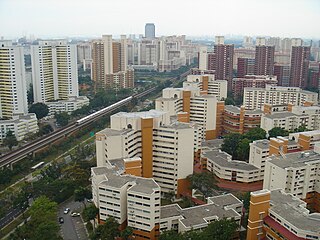
WAng Mo Kio, often abbreviated as AMK, is a planning area and residential town situated in the North-East of Singapore. Ang Mo Kio is the 3rd most populated planning area in the North-East Region and ranks 8th in terms of population in the country overall. The planning area is located at the south-western corner of the North-East Region, bordered by the planning areas of Yishun to the north, Sengkang to the north-east, Serangoon to the east, Bishan to the south and the Central Water Catchment to the west.
 W
WBishan, also known as either Bishan New Town or Bishan Town, is a planning area and matured residential town located at the northernmost portion of the Central Region of Singapore. Statistically, the area is ranked the 38th biggest in terms of geographical size and the 22nd most populated planning area in the country. It is located at the most Central point of Singapore, and is made out of Upper Thomson, Marymount, Shunfu, Sin Ming, Bishan North and Bishan East. There are also many private residential properties in Bishan. This however, makes Bishan ranked 15th in terms of population density. Apart from its boundary with the Central Water Catchment in the west, Bishan borders three other planning areas - Ang Mo Kio to the north, Toa Payoh to the south and Serangoon to the east.
 W
WBukit Batok, often abbreviated as Bt Batok, is a planning area and matured residential town located along the eastern boundary of the West Region of Singapore. Bukit Batok statistically ranks in as the 25th largest, the 12th most populous and the 11th most densely populated planning area in the Republic. It is bordered by six other planning areas - Choa Chu Kang to the North, northeast and northwest, Cashew to the northeast and east, Clementi to the south, Bukit Timah to the southeast, Jurong East to the southwest and Tengah to the west.
 W
WBukit Panjang, often abbreviated as Bt Panjang or simply BP, is a planning area and residential town located in the West Region of Singapore. The planning area is bounded by Bukit Batok to the west, Choa Chu Kang to the northwest, Sungei Kadut to the north, the Central Water Catchment to the east and Bukit Timah to the south. Bukit Panjang New Town is located at the northern portion of the planning area. Bukit Panjang has an average elevation of 36m/118 ft and a portion of this town is situated on a low-lying elongated hill.
 W
WChoa Chu Kang, alternatively spelt as Chua Chu Kang and often abbreviated as CCK, is a planning area and residential town located at the north-westernmost point of the West Region of Singapore. The town shares borders with Sungei Kadut to the north, Tengah to the southwest, Bukit Batok to the southeast, Bukit Panjang to the east and the Western Water Catchment to the west. Choa Chu Kang New Town is separated into two portions by the Kranji Expressway.
 W
WClementi (;) is a planning area and residential town located at the easternmost fringe of the West Region of Singapore. The town borders Bukit Batok to the north, Bukit Timah to the northeast, Queenstown to the east and Jurong East to the west.
 W
WJurong is a geographical region located at the south-westernmost point of the West Region of Singapore. Although mostly vaguely defined, the region's extent roughly covers the planning areas of Jurong East, Jurong West, Boon Lay, and Pioneer, along with Jurong Island in the Western Islands cluster and the southernmost portions of the Western Water Catchment. Should it be described at its greatest historical extent, the region can also include present-day Bukit Batok and Tuas as well. Jurong also covers several offshore islands as well, including Pulau Damar Laut and Pulau Samulun, both of which are located within the planning areas of Jurong East and Boon Lay respectively; along with the aforementioned Jurong Island. The coastline of the region on mainland Singapore, faces the strait of Selat Jurong, while the southernmost island of the region, Jurong Island, faces the strait of Selat Pandan.
 W
WJurong East is a planning area and residential town located in the West Region of Singapore. It borders Jurong West and Boon Lay to the west, Clementi to the east, Tengah and Bukit Batok to the north and Selat Jurong to the south.
 W
WJurong West is a planning area and residential town located in the West Region of Singapore. Jurong West shares boundaries with Tengah in the north, Jurong East in the east, Boon Lay and Pioneer in the south, and Western Water Catchment in the west.
 W
WSengkang is a planning area and residential town located in the North-East Region of Singapore. The town is the second most populous in the region, being home to 244,600 residents in 2019. Sengkang shares boundaries with Seletar and Punggol in the north, Pasir Ris and Paya Lebar in the east, Hougang and Serangoon to the south, as well as Yishun and Ang Mo Kio to the west.
 W
WToa Payoh is a planning area and matured residential town located in the northern part of the Central Region of Singapore. Toa Payoh planning area borders Bishan and Serangoon to the north, the Central Water Catchment to the northwest, Kallang to the south, Geylang to the southeast, Novena to the west and Hougang to the east. Toa Payoh New Town is situated in the eastern portion of the Toa Payoh planning area. The latter occupies a much larger area, encompassing estates such as Potong Pasir and Bidadari.
 W
WWoodlands is a planning area and residential town located in the North Region of Singapore. The town has a population of 252,530 within an area of 4.8 km2. It is the regional centre for the North Region of the city-state. The Woodlands planning area borders Sembawang to the east, Mandai to the south and Sungei Kadut to the west. Woodlands New Town is situated within the Woodlands planning area.