 W
WThe geography of Australia encompasses a wide variety of biogeographic regions being the world's smallest continent while comprising the territory of the sixth-largest country in the world. The population of Australia is concentrated along the eastern and southeastern coasts. The geography of the continent is extremely diverse, ranging from the snow-capped mountains of the Australian Alps and Tasmania to large deserts, tropical and temperate forests.
 W
WThe Australian Height Datum was introduced in 1971 as the official vertical datum for Australia, and thereby serves as the benchmark for which all height measurements are referenced to. The Australian Height Datum is an amalgamation of decades of spirit levelling work conducted by numerous state and territory authorities across the country, and was corrected to align with the mean sea level observations of thirty tide gauges positioned around the entire coastline. While it still remains the published vertical datum for all surveying and engineering operations performed throughout Australia, newer technologies have uncovered numerous deficiencies, offsets and distortions within the Australian Height Datum, leading to discussions about defining a new Australian vertical datum.
 W
W"The bush" is a term mostly used in the English vernacular of Australia and New Zealand where it is largely synonymous with backwoods or hinterland, referring to a natural undeveloped area. The fauna and flora contained within this area must be indigenous to the region, although exotic species will often also be present.
 W
WCentre points of Australia are those geographical locations that have been considered to be centre of Australia, as distinct from the extreme points of Australia.
WThe coastline of Australia comprises the coasts of mainland Australia and Tasmania. It nominally includes a part of all Australian states and territories; the otherwise landlocked Australian Capital Territory has a coastal enclave at Jervis Bay Territory.
 W
WThis article covers the science, art and industry of cartography by the people of the Low Countries in the early modern period, especially in the early 16th to early 18th centuries. It includes cartography of the Northern Netherlands, Southern Netherlands and Low Countries in general. It also includes Dutch colonial cartography, i.e. cartography in the Dutch overseas world, in the early modern period.
WThis article covers the science, art and industry of cartography by the people of the Low Countries in the early modern period, especially in the early 16th to early 18th centuries. It includes cartography of the Northern Netherlands, Southern Netherlands and Low Countries in general. It also includes Dutch colonial cartography, i.e. cartography in the Dutch overseas world, in the early modern period.
 W
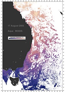
WThe East Australian Current (EAC) is the southward western boundary current that is formed from the South Equatorial Current (SEC) crossing the Coral Sea and reaching the eastern coast of Australia. At around 15° S near the Australian coast the SEC divides forming the southward flow of the EAC. It is the largest ocean current close to the shores of Australia. The EAC reaches a maximum velocity at 30° S where its flow can reach 90 cm/s. As it flows southward it splits from the coast at around 31° to 32° S. By the time it reaches 33° S it begins to undergo a southward meander while another portion of the transport turns back northward in a tight recirculation. At this location the EAC reaches its maximum transport of nearly 35 Sv. The majority of the EAC flow that does not recirculate will move eastward into the Tasman Front crossing the Tasman Sea just north of the cape of New Zealand. The remaining will flow south on the EAC Extension until it reaches the Antarctic Circumpolar Current. The Tasman Front transport is estimated at 13 Sv. The eastward movement of the EAC through the Tasman Front and reattaching to the coastline of New Zealand forms the East Auckland Current. The EAC also acts to transport tropical marine fauna to habitats in sub-tropical regions along the south east Australian coast.
Geoscience Australia is an agency of the Australian Government. It carries out geoscientific research. The agency is the government's technical adviser on all aspects of geoscience, and custodian of the geographic and geological data and knowledge of the nation.
 W
WThe Hornsby Plateau is a sandstone plateau lying to the north of Sydney Harbour, which rises to 200 metres and is dissected by steep valleys. The plateau is part of a larger geological structure named the Sydney Basin.
 W
WIceberg B-17B was an iceberg twice the size of Manhattan, that floated in the southern ocean approximately 1,700 kilometres (1,100 mi) off the coast of Western Australia. Iceberg B-17B measured approximately 140 square kilometres (54 sq mi).B-17B originated in the first half of 2000 when the iceberg B17 split into two parts. B17 itself had broken off from the Ross Ice Shelf two months before.
 W
WMainland Australia is the main landmass of the Australian continent, excluding Tasmania and other offshore islands. The landmass also constitutes the mainland of the territory governed by the Commonwealth of Australia, and the term, along with continental Australia, can be used in a geographic sense to exclude surrounding continental islands and external territories. Generally, the term is applied to the states of New South Wales, Queensland, South Australia, Victoria, and Western Australia, as well as the Australian Capital Territory, Jervis Bay Territory, and Northern Territory.
 W
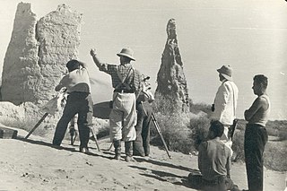
WA triangulation station, also known as a trigonometrical point, and sometimes informally as a trig, is a fixed surveying station, used in geodetic surveying and other surveying projects in its vicinity. The nomenclature varies regionally: they are generally known as trigonometrical or triangulation stations in North America, trig points in the United Kingdom, trig pillars in Ireland, trig stations or points in Australia and New Zealand, and trig beacons in South Africa; triangulation pillar is the more formal term for the concrete columns found in the UK, however, the informal term, "trig point", is used more often.