 W
WThe geography of Texas is diverse and large. Occupying about 7% of the total water and land area of the U.S., it is the second largest state after Alaska, and is the southernmost part of the Great Plains, which end in the south against the folded Sierra Madre Oriental of Mexico. Texas is in the South Central United States of America, and is considered to form part of the U.S. South and also part of the U.S. Southwest.
 W
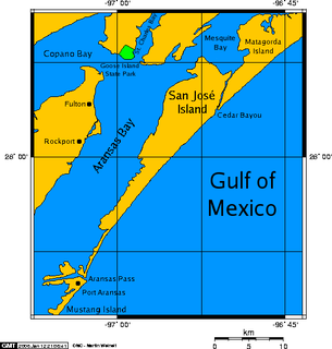
WAransas is a placename for several neighboring places in coastal Southern Texas.Aransas County, Texas The Aransas River, which begins in Bee County, Texas, and flows into Copano Bay in Aransas County The Aransas Bay, fed by Copano Bay Aransas Pass, Texas, which borders the Aransas Bay Port Aransas, Texas The Aransas Pass, a navigable salt water channel connecting the Gulf of Mexico with Aransas Bay The Aransas National Wildlife Refuge, north of Aransas River The ghost town of Aransas City
 W
WThe Big Thicket is the name given to a somewhat imprecise region of a heavily forested area in Southeast Texas in the United States. It is a highly biodiverse area for a temperate region, that has been described as "America's Ark" and the "Biological Crossroads of North America". The National Park Service established the Big Thicket National Preserve (BTNP) within the region in 1974 and it is recognized as a biosphere reserve by UNESCO. Although the diversity of animals in the area is high, with over 500 vertebrates, it is the complex mosaic of ecosystems and plant diversity that is particularly remarkable. Biologists have identified at least eight, and up to eleven, ecosystems in the Big Thicket area. More than 160 species of trees and shrubs, 800 herbs and vines, and 340 types of grasses are known to occur in the Big Thicket, and estimates as high as over 1000 flowering plant species and 200 trees and shrubs have been made, plus ferns, carnivorous plants, and more. The Big Thicket has historically been the most dense forest region in what is now Texas.
 W
WThe Comancheria or Comanchería is the region of New Mexico, west Texas and nearby areas occupied by the Comanche before the 1860s.
 W
WThe Edwards Plateau is a geographic region at the crossroads of Central, South, and West Texas. It is bounded by the Balcones Fault to the south and east, the Llano Uplift and the Llano Estacado to the north, and the Pecos River and Chihuahuan Desert to the west. San Angelo, Austin, San Antonio and Del Rio roughly outline the area. The southeast portion of the plateau is known as the Texas Hill Country.
 W
WHorsehead Crossing is a ford on the Pecos River in Crane County, south of Odessa, Texas. Historically, it was a major landmark on the trail west as one of a few fordable sections of the Pecos in West Texas, and as the first reliable source of water for about 75 miles on the route from the east.
 W
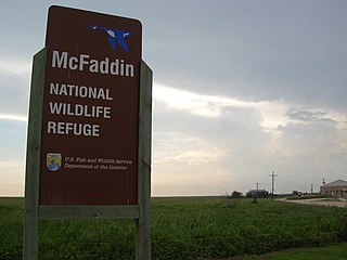
WThe McFaddin and Texas Point National Wildlife Refuges are located in proximity in southern Jefferson County on the upper Texas coast at Sabine Pass. The refuges have a combined 105.96 square miles (274.4 km2) of fish and wildlife habitat. McFaddin, much the larger one, located at around 29°40′00″N 94°09′00″W, has a total area of 58,861.43 acres (238.20 km²), while the smaller Texas Point, located at around 29°42′00″N 93°53′00″W, has 8,952.02 acres (36.23 km²).
 W
WThe Mexico–United States border is an international border separating Mexico and the United States, extending from the Pacific Ocean in the west to the Gulf of Mexico in the east. The border traverses a variety of terrains, ranging from urban areas to deserts. The Mexico–United States border is the most frequently crossed border in the world, with approximately 350 million documented crossings annually. It is the tenth-longest border between two countries in the world.
 W
WSam Rayburn Reservoir is a reservoir in the United States in Deep East Texas, 70 mi (110 km) north of Beaumont. The reservoir is fed by the Angelina River, the major tributary of the Neches River. The Reservoir is upstream of the Big Thicket National Preserve.
 W
WThe southwestern tablelands is an ecoregion running from east-central to south-east Colorado, east-central and a small portion of east New Mexico, some eastern portions of the Oklahoma Panhandle, far south-central Kansas and portions of northwest Texas. This ecoregion has a "cold semi-arid" climate. Some years, a National Weather Service warning is issued in parts of Texas due to a dust storm originating from the lower part of the Southwestern Tablelands ecological region or from the southern end of the Western High Plains ecological region.
 W
WThe Tamaulipan mezquital is a deserts and xeric shrublands ecoregion in the southern United States and northeastern Mexico. It covers an area of 141,500 km2 (54,600 sq mi), encompassing a portion of the Gulf Coastal Plain in southern Texas, northern Tamaulipas, northeastern Coahuila, and part of Nuevo León.
 W
WThe Texas High Plains AVA is an American Viticultural Area located on the Llano Estacado region of Texas. The appellation is the second largest American Viticultural Area in Texas, and covers an area of over 8,000,000 acres (32,375 km2). Most of the vineyards are on flat terrain at elevations between 3,000 feet (914 m) and 4,000 feet (1,219 m) above sea level. The Texas plains can be extremely dry, so most vineyards are irrigated with water from the Ogallala Aquifer. The hardiness zones are 7a and 7b.
 W
WThe Winter Garden Region is an agricultural area in South Texas (USA) located north of Laredo and southwest of San Antonio. The region is centered on four "core" counties - Dimmit, Frio, La Salle, and Zavala, but also includes parts of Atascosa, Maverick, and McMullen counties.