 W
WGreenland is the largest island on Earth. Only one-fifth of its surface area is exposed bedrock, the rest being covered by ice. The exposed surface is approximately 410,000 km2.
 W
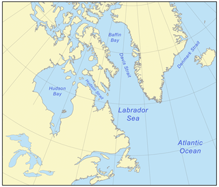
WThe Canadian Arctic Rift System is a major North American geological structure extending from the Labrador Sea in the southeast through Davis Strait, Baffin Bay and the Arctic Archipelago in the northwest. It consists of a series of interconnected rifts that formed during the Paleozoic, Mesozoic and Cenozoic eras. Extensional stresses along the entire length of the rift system have resulted in a variety of tectonic features, including grabens, half-grabens, basins and faults.
 W
WThe Canadian Shield, also called the Laurentian Plateau, is a large area of exposed Precambrian igneous and high-grade metamorphic rocks that forms the ancient geologic core of the North American continent. Glaciation has left the area only a thin layer of soil, through which the composition of igneous rock resulting from long volcanic history is frequently visible. With a deep, common, joined bedrock region in eastern and central Canada, the Shield stretches north from the Great Lakes to the Arctic Ocean, covering over half of Canada and most of Greenland; it also extends south into the northern reaches of the United States. Human population is sparse and industrial development is minimal, but mining is prevalent.
 W
WThe Cape York meteorite, also known as the Innaanganeq meteorite, is one of the largest known iron meteorites, classified as a medium octahedrite in chemical group IIIAB. In addition to many small fragments, at least eight large fragments with a total mass of 58 tons have been recovered, the largest weighing 31 tonnes. The meteorite is loosely named after the location where the largest fragment was found: 23 miles (37 km) east of Cape York, in Savissivik, Meteorite Island, Greenland.
 W
WThe Franklin Large Igneous Province is a Neoproterozoic large igneous province in the Canadian Arctic of Northern Canada. It represents one of the largest large igneous provinces in Canada, consisting of the Natkusiak flood basalts on Victoria Island, the Coronation sills on the southern shore of the Coronation Gulf and the large Franklin dike swarm, which extends for more than 1,200 km (750 mi) across the Canadian Arctic Archipelago and northwestern Greenland. The Franklin Large Igneous Province covers an area of more than 1,100,000 km2 (420,000 sq mi).
 W
WThe Geological Survey of Denmark and Greenland is the independent sector research institute under the Danish Ministry of Climate and Energy. GEUS is an advisory, research and survey institute in hydrogeology, geophysics, geochemistry, stratigraphy, glaciology, ore geology, marine geology, mineralogy, climatology, environmental history, air photo interpretation, geothermal energy fields concerning Denmark and Greenland.
 W
WThe Ilimaussaq intrusive complex is a large alkalic layered intrusion located on the southwest coast of Greenland. It is Mesoproterozoic in age, about 1.16 Ga. It is the type locality of agpaitic nepheline syenite and hosts a variety of unusual rock types.
 W
WThe Innuitian orogeny, sometimes called the Ellesmere orogeny, was a major tectonic episode responsible for the formation of a series of mountain ranges in the Canadian Arctic and Northernmost Greenland. The episode started with the earliest Paleozoic rifting, extending from Ellesmere Island to Melville Island.
 W
WKvanefjeld, in Greenland, is the site of a mineral deposit, which is claimed to be the world's second-largest deposit of rare-earth oxides, and the sixth-largest deposit of uranium. There are also substantial sodium fluoride deposits, and Kvanefjeld is thought to be one of the largest multi-element deposits of its kind in the world.
 W
WLaurasia, a portmanteau for Laurentia and Asia, was the more northern of two minor supercontinents that formed part of the Pangaea supercontinent from c. 425 million years ago (Mya) to 200 Mya. It separated from Gondwana 215 to 175 Mya during the breakup of Pangaea, drifting farther north after the split and finally broke apart with the opening of the North Atlantic Ocean c. 56 Mya.
 W
WThe Maniitsoq structure is a proposed 3 billion year old impact structure located in the Akia Terrane of the North Atlantic Craton, centred about 55 km (34 mi) south-east of the town of Maniitsoq, Greenland, at 65°15′N 51°50′W. However, the Maniitsoq structure has not been widely recognised as an impact structure, and the proposal was criticised for not meeting established criteria for recognising impact craters. Subsequent studies in the region have found no evidence for an impact structure, and a number of observations that directly contradict the earlier impact structure proposals. The Maniitsoq structure is not recognised as an impact structure by the Earth Impact Database.
 W
WThe North American Plate is a tectonic plate covering most of North America, Greenland, Cuba, the Bahamas, extreme northeastern Asia, and parts of Iceland and the Azores. With an area of 76 million km2 (29 million sq mi), it is the Earth's second largest tectonic plate, behind the Pacific Plate.
 W
WThe North Atlantic Igneous Province (NAIP) is a large igneous province in the North Atlantic, centered on Iceland. In the Paleogene, the province formed the Thulean Plateau, a large basaltic lava plain, which extended over at least 1.3 million km2 (500 thousand sq mi) in area and 6.6 million km3 (1.6 million cu mi) in volume. The plateau was broken up during the opening of the North Atlantic Ocean leaving remnants existing in Northern Ireland, bits of western Scotland, the Faroe Islands, bits of northwestern Iceland, eastern Greenland and western Norway and many of the islands located in the north eastern portion of the North Atlantic Ocean. The igneous province is the origin of the Giant's Causeway and Fingal's Cave. The province is also known as Brito-Arctic province and the portion of the province in the British Isles is also called the British Tertiary Volcanic Province or British Tertiary Igneous Province.