 W
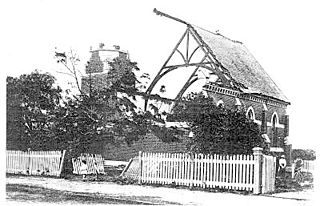
WThe 1893 Brisbane flood, occasionally referred to as the Great Flood of 1893 or the Black February flood, occurred in 1893 in Brisbane, Queensland, Australia. The Brisbane River burst its banks on three occasions in February 1893. It was the occurrence of three major floods in the same month that saw the period named "Black February". There was also a fourth flood event later in the same year in June. The river runs through the centre of Brisbane with much of the population living in areas beside the river. It was flooded in the first flood on 6 February due to a deluge associated with a tropical cyclone, called "Buninyong".
 W
WThe 1897 cyclone was a tropical cyclone that destroyed the city of Darwin in the Northern Territory of Australia. It is considered the worst cyclone to strike the Northern Territory of Australia prior to Cyclone Tracy in 1974. Prior to contemporary naming conventions, the storm became known as the "Great Hurricane".
 W
WIn January 1974 a flood occurred in Brisbane, Queensland, Australia after three weeks of continual rain. The Brisbane River, which runs through the heart of the city, broke its banks and flooded the surrounding areas. The cyclone that produced the flood also flooded surrounding cities: Ipswich, Beenleigh, and the Gold Coast.
 W
WThe 2009 Australian dust storm, also known as the Eastern Australian dust storm, was a dust storm that swept across the Australian states of New South Wales and Queensland from 22 to 24 September 2009. The capital, Canberra, experienced the dust storm on 22 September, and on 23 September the storm reached Sydney and Brisbane. Some of the thousands of tons of dirt and soil lifted in the dust storm were dumped in Sydney Harbour and the Tasman Sea.
 W
WThe 2010 Gascoyne River flood was regarded as the most severe flood to take place along the Gascoyne River in Western Australia on record. Triggered by record-breaking rainfall, amounting to over 6,000 percent of the monthly mean, 313.6 mm (12.35 in) and 5 mm (0.20 in) respectively, in just four days, the floods caused widespread damage in the region. By 17 December, the river began to rise in response to the heavy rains, eventually exceeding its banks within two days. Water levels reached record values at three stations along the river, cresting at 15.53 m (51.0 ft) near Fishy Pool. Evacuation orders were issued for several towns affected by rising waters. The most substantial impact was felt in Carnarvon where entire homes were washed away. Following the disaster, emergency supplies and funds were distributed to affected residents to aid them in restoring their livelihoods. Though no people died in the event, an estimated two thousand head of cattle perished and damage was estimated at A$100 million.
 W
WThe 2010 Victorian storms were a series of storms that passed through much of the Australian state of Victoria on 6 and 7 March 2010. One of the most severe storms passed directly over Greater Melbourne, bringing lightning, flash flooding, very large hail and strong winds to the state's capital.
 W
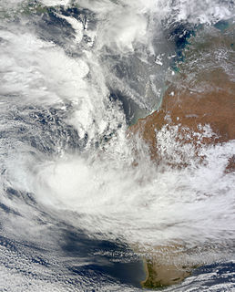
WA series of floods hit Queensland, Australia, beginning in November 2010. The floods forced the evacuation of thousands of people from towns and cities. At least 90 towns and over 200,000 people were affected. Damage initially was estimated at around A$1 billion before it was raised to $2.38 billion. The estimated reduction in Australia's GDP is about A$30 billion. As at March 2012, there were 33 deaths attributed to the 2010–11 Queensland floods with a further three people still missing.
 W
WAustralian east coast lows are extratropical cyclones. The most intense of these systems have many of the characteristics of subtropical cyclones. They develop between 25˚ south and 40˚ south and within 5˚ of the Australian coastline, typically during the winter months, but may occur in autumn and spring as well. Each year there are about ten "significant impact" maritime lows.
 W
WA Black nor'easter is a persistent and potentially violent north-easterly storm that occurs on the east coast of Australia during spring and summer, usually about two days a year. It is not a convection wind, but a storm system that develops offshore which can last several days. This is heralded by the rapid build-up of dense black cloud that can convert to a gale in well under one hour, and also bringing with it a heavy rainfall event usually accompanied by a thunderstorm. This type of storm was first recorded during the 1800s.
 W
WSevere storm events in Sydney are not uncommon and would include hail storms, wind storms, and flash flooding from rain caused either by East coast lows or ex-tropical cyclone remnants. East coast lows are low pressure depressions that can bring significant damage by heavy rain, cyclonic winds and huge swells. Sydney is rarely affected by cyclones, although remnants of ex-cyclones do affect the city.
 W
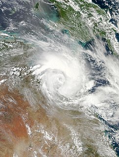
WTropical Cyclone Oswald in 2013 passed over parts of Queensland and New South Wales, Australia over a number of days, causing widespread impact including severe storms, flooding, and water spouts. Coastal regions of Queensland were the most impacted with Mundubbera, Eidsvold, Gayndah and Bundaberg in the Wide Bay–Burnett hit severely. In many places the rainfall total for January set new records. Across the affected region, damage from severe weather and flooding amounted to at least A$2.4 billion.
 W
WExtreme weather events in Melbourne, Australia have occurred on multiple occasions. The city has experienced a number of highly unusual weather events and extremes of weather. An increase in heat waves and record breaking temperatures in the 21st century has led to much discussion over the effects of climate change in the country.
 W
WA southerly buster is the colloquial name of an abrupt southerly wind change in the southern regions of New South Wales and Victoria, Australia, which approaches from the southeast, mainly on a hot day, bringing in cool, usually severe weather and a dramatic temperature drop, thus ultimately replacing and relieving the prior hot conditions. Marking the boundary between hot and cool air masses, a southerly buster is sometimes represented by a roll-up cloud perpendicular to the coast, which appears from the south and coexists with the wind change, though sometimes there is little visual signal of the southerly's arrival.