 W
WThere were many areas annexed by Nazi Germany both immediately before and throughout the course of World War II. Territories that were part of Nazi Germany before the annexations were known as the "Altreich".
 W
WThe Austria–Germany border has a length of 815.9 km (507.0 mi) or 815.0 km (506.4 mi) in the south of Germany and the north of Austria in central Europe. It is the longest border of both Austria and Germany with another country.
 W
WThe Czech Republic–Germany border is the international border between the Czech Republic and Germany. It forms a 815 kilometres (506 mi) arc extending from Austria at the south to Poland at the north.
 W
WThe Denmark–Germany border is 68 kilometres (42 mi) long and separates Denmark and Germany.
 W
WThe border between the countries of France and Germany has a length of about 450 km (280 mi).
 W
WThe Friendship Bridge is a bridge which crosses the Saar river, south of Saarbrücken, and links the Saarland municipality of Kleinblittersdorf with the Lorraine commune of Grosbliederstroff.
 W
WThe German–Soviet Border and Commercial Agreement, signed on January 10, 1941, was a broad agreement which settled border disputes, and continued raw materials and war machine trade between the Soviet Union and Nazi Germany. The agreement continued the countries' relationship that started in 1939 with the Molotov–Ribbentrop Pact, which contained secret protocols that divided Eastern Europe between the Soviet Union and Germany. The relationship had continued with the subsequent invasions by Germany and the Soviet Union of that territory. The German–Soviet Border and Commercial Agreement contained additional secret protocols, settling a dispute regarding land in Lithuania which was previously split between the countries. The agreement continued the Nazi–Soviet economic relations that had been expanded by the 1939 German–Soviet Commercial Agreement and the larger 1940 German–Soviet Commercial Agreement.
 W
WThe German–Soviet Frontier Treaty was a second supplementary protocol of the Molotov–Ribbentrop Pact of 23 August. It was a secret clause as amended on September 28, 1939, by Nazi Germany and the Soviet Union after their joint invasion and occupation of sovereign Poland. It was signed by Joachim von Ribbentrop and Vyacheslav Molotov, the foreign ministers of Germany and the Soviet Union respectively, in the presence of Joseph Stalin. Only a small portion of the protocol, which superseded the first treaty, was publicly announced while the spheres of influence of Nazi Germany and the Soviet Union remained classified. The third secret protocol of the Pact was signed on January 10, 1941, by Friedrich Werner von Schulenburg, and Molotov, wherein Germany renounced its claims to portions of Lithuania, only a few months before their anti-Soviet Operation Barbarossa.
 W
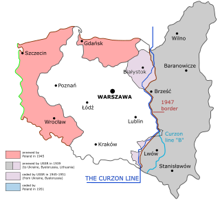
WThe Germany–Poland border, the state border between Poland and Germany, is currently the Oder–Neisse line. It has a total length of 467 km (290 mi) and has been in place since 1945. It stretches from the Baltic Sea in the north to the Czech Republic in the south.
 W
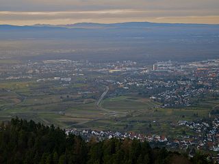
WThe border between the modern states of Germany and Switzerland extends to 362 kilometres (225 mi), mostly following the High Rhine between Lake Constance and Basel.
 W
WThe Recovered Territories are the territories of the former Free City of Danzig and of pre-war Germany that became part of Poland after World War II, at which time their former German inhabitants were forcibly deported.
 W
WSilesian Przesieka, literally Silesian Cutting was a densely forested, uninhabited and unpassable strip of land in the middle of Silesia, spreading from Golden Mountains in the south, along the Nysa Kłodzka to the Odra, and then along the Stobrawa, reaching the towns of Namysłów and Byczyna in northern Silesia. Originally, the Silesian Cutting was a boundary, separating territories of two Western Slavic tribes, the Slezanie and the Opolanie. In the 12th century, along the Cutting a border of Lower Silesia and Upper Silesia was established.
 W
WThe Treaty of Eger, also called Main Compromise of Eger or Peace of Eger was concluded on 25 April 1459 in the Imperial City of Eger (Cheb), administrative seat of the immediate pawn of Egerland. The treaty established the border between the Kingdom of Bohemia and the Electorate of Saxony on the main ridge of the Ore Mountains stretching from Eger to the River Elbe. The border remains largely unchanged up to today, separating the Czech Republic and Germany, and is thus one of the oldest still extant borders in Europe.
 W
WThe Treaty on the Final Settlement with Respect to Germany, or the Two Plus Four Agreement, was negotiated in 1990 between the Federal Republic of Germany and the German Democratic Republic, and the Four Powers which occupied Germany at the end of World War II in Europe: France, the Soviet Union, the United Kingdom, and the United States. In the treaty, the Four Powers renounced all rights they held in Germany, allowing a reunited Germany to become fully sovereign the following year. At the same time, the two German states agreed to confirm their acceptance of the existing border with Poland, and accepted that the borders of Germany after unification would correspond only to the territories then administered by West and East Germany, with the exclusion and renunciation of any other territorial claims.
 W
WWest Germany is the common English name for the Federal Republic of Germany, retrospectively designated the Bonn Republic, in the period between its formation on 23 May 1949 and German reunification on 3 October 1990. During this Cold War period, the western portion of Germany was part of the Western Bloc. The FRG was created during the Allied occupation of Germany after World War II, established from eleven states formed in the three Allied zones of occupation held by the United States, the United Kingdom and France. Its provisional capital was the city of Bonn.