 W
WThe extreme points of Japan include the coordinates that are farthest north, south, east and west in Japan, and the ones that are at the highest and the lowest elevations in the country. Japan's northernmost point is disputed, because Japan considers it to be on Iturup, an island de facto governed by Russia. The southernmost point is Okinotorishima; the westernmost is Cape Irizaki in Okinawa Prefecture, and the easternmost is Minami Torishima. The highest point in Japan is the summit of Mount Fuji at 3,776.24 m (12,389 ft). At 150 m (492 ft) below sea level, the bottom of Hachinohe mine is the country's lowest point. The surface of Hachirōgata is Japan's lowest natural point at 4 m (13 ft) below sea level. With the exception of Cape Irizaki, the westernmost location of Japan, all other extreme locations are uninhabited.
 W
WBenten-jima (弁天島) is a small deserted island west by northwest of Cape Sōya, Wakkanai, Hokkaidō, Japan. It is the northernmost piece of land under Japanese control. The island is 1 km north of Sannai settlement. Another island called Hira-shima (平島) lies southeast of Benten-jima.
 W
WCape Irizaki is the western tip of Yonaguni Island and the westernmost point in Japan. The cape is within the town of Yonaguni, Okinawa.
 W
WCape Ōma is the northernmost point of the island of Honshu in Japan. It is located within the borders of the town of Ōma, Aomori in northern Shimokita Peninsula, and is part of the Shimokita Hantō Quasi-National Park. The cape extends into the Tsugaru Strait separating Honshu from Hokkaido, which is 18 kilometres (11 mi) away. On a clear day, Mount Hakodate on the island of Hokkaido to the north can be seen.
 W
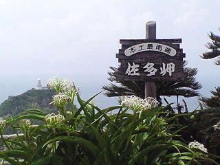
WCape Sata is a cape at the southern tip of the Ōsumi Peninsula of Kyūshū island, Japan, and is the southernmost point of the island, just south of 31 degrees latitude.
 W
WCape Sōya is the northernmost point of the island of Hokkaidō, Japan. It is situated in Wakkanai, Sōya Subprefecture. The Monument of the Northernmost Point of Japan (日本最北端の地の碑) is at the cape, although the true northernmost point under Japanese control is a small deserted island called Bentenjima, 1 kilometre (3,300 ft) northwest. Since the cape is just 43 kilometres (27 mi) away across La Perouse Strait from Cape Crillon, Sakhalin Island, Russia, it is possible to catch a glimpse of the island of Sakhalin on a clear day.
 W
WCape Todo , also written as "魹ヶ崎" is the easternmost point of the island of Honshu in Japan. It is located within the borders of the city of Miyako, Iwate, and is part of the Sanriku Fukkō National Park. Although referred to as a “cape”, the area is not clearly a peninsula extending into the Pacific Ocean, but is simply the easternmost point on a coastline.
 W
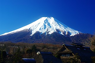
WMount Fuji , located on the island of Honshū, is the highest mountain in Japan, standing 3,776.24 m (12,389.2 ft). It is the second-highest volcano located on an island in Asia, and seventh-highest peak of an island on Earth. Mount Fuji is an active stratovolcano that last erupted from 1707 to 1708. The mountain stands about 100 km (62 mi) southwest of Tokyo and is visible from there on clear days. Mount Fuji's exceptionally symmetrical cone, which is snow-capped for about five months of the year, is commonly used as a cultural icon of Japan and it is frequently depicted in art and photography, as well as visited by sightseers and climbers.
 W
WThe Hachinohe mine is a limestone quarry in the city of Hachinohe, Aomori Prefecture, in the northern Tohoku region of northern Japan. It is operated by the Sumimetal Mining Company.
 W
WHachirōgata or Hachirō Lagoon is a lake in Akita Prefecture in northern Japan. Its formal name is Lake Hachirō , but it is also called Hachirōgata Regulating Pond . At 4 meters below sea level, Hachirōgata is the lowest natural point in Japan.
 W
WHateruma is an island in the Yaeyama District of Okinawa Prefecture, Japan. Part of the town Taketomi, it is the southernmost inhabited island in Japan at 24°2’25" north latitude, 123°47’16" east longitude. Hateruma is one of the Yaeyama Islands, and is located 24 kilometres (15 mi) south of Iriomote-jima, the largest of the island group.
 W
WKōzakihana (神崎鼻) is a cape located in Sasebo, Nagasaki, Japan. It is the westernmost point of the island Kyūshū as well as the westernmost point of Japan's four main islands.
 W
WMinami-Tori-shima , also known as Marcus Island, is an isolated Japanese coral atoll in the northwestern Pacific Ocean, located some 1,848 kilometers (1,148 mi) southeast of Tokyo and 1,267 km (787 mi) east of the closest Japanese island, South Iwo Jima of the Ogasawara Islands, and nearly on a straight line between mainland Tokyo and Wake Island, 1,415 km (879 mi) further to the east-southeast. The closest island to Minami-Tori-shima is East Island in the Mariana Islands, which is 1,015 km (631 mi) to the west-southwest.
 W
WOkinotorishima is a coral reef with two rocks enlarged with tetrapod-cement structures. It is administered by Japan with a total shoal area of 8,482 m2 and land area 9.44 square metres (101.6 sq ft). Its dry land area is mostly made up by three concrete encasings and there is a 100 by 50 m stilt platform in the lagoon housing a research station. There is a third complete artificial tetrapod-cement islet. It is located on the Palau–Kyushu Ridge in the Philippine Sea, 534 km (332 mi) southeast of Okidaitōjima and 567 km (352 mi) west-southwest of South Iwo Jima in the Bonin Islands or 1,740 km (1,080 mi) south of Tokyo, Japan. The atoll is the southernmost part of Japan and the only Japanese territory in the tropics.
 W
WYonaguni , one of the Yaeyama Islands, is the westernmost inhabited island of Japan, lying 108 kilometers (67 mi) from the east coast of Taiwan, between the East China Sea and the Pacific Ocean proper. The island is administered as the town of Yonaguni, Yaeyama Gun, Okinawa, and there are three settlements: Sonai, Kubura, and Higawa.