 W
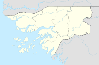
WGabú Region is the easternmost region in Guinea-Bissau. Its capital is Gabú. The region borders Senegal to the north, Guinea to the east and south and the Guinea-Bissau regions of Tombali and Bafatá to the west. It covers an area of 9,150 km2, making it the largest of Guinea-Bissau's administrative regions. It is an inland region covered with Savannah or light Savannah woodland and receives an annual rainfall of more than 2,000 mm (79 in).
 W
WBoe is a settlement in the southeastern Gabú Region of Guinea-Bissau. The population is mostly of poor Fulani speaking herders. Although geologically rich in bauxite, the mineral deposits have not been exploited to any great degree due to the ecological sensitivity of the surrounding Boé National Park.
 W
WBuruntuma is a village in the Gabú Region of north-eastern Guinea-Bissau. It lies on the border with Guinea, to the southeast of Canquelifá.
WCã Mamudo is a village in the Gabú Region of central-eastern Guinea-Bissau. It lies to the west of Lenquete and southeast of Sonaco.
WCamajábà is a village in the Gabú Region of north-eastern Guinea-Bissau. It lies to the southwest of Buruntuma and west of Piche.
 W
WCanjadude is a village in the Gabú sector of the Gabú Region in north-eastern Guinea-Bissau. It lies to the south of Uelíngarà. Canjadude, along with Catió and other camps were besieged by the Portuguese in 1973.
WCanjia is a village in the Gabú Region of central-eastern Guinea-Bissau. It lies to the east of Uacaba and north of Cansisse.
WCanquelifá is a village in the Gabú Region of north-eastern Guinea-Bissau. It lies to the northwest of Buruntuma.
WCansisse is a village in the Gabú Region of central-eastern Guinea-Bissau. It lies to the south of Canjia.
WCarantaba is a village in the Gabú Region of north-eastern Guinea-Bissau. It lies to the northwest of Piche and northeast of Gabú.
WChéché or Ché Ché is a village in the Gabú Region of north-eastern Guinea-Bissau. It lies on the south of the Corubal River, to the south of Canjadude. The river crossing was the site of the Cheche Disaster of 6 February 1969, in which about 50 Portuguese soldiers drowned in an accident when their ferry tipped over.
 W
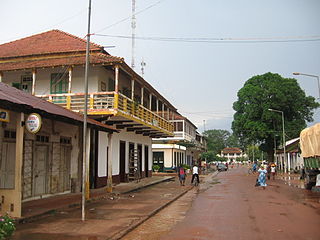
WGabu is the largest town in eastern Guinea-Bissau and capital of the Gabu Region.
WLenquete is a village in the Gabú Region of central-eastern Guinea-Bissau. It lies to the northwest of Gabú.
WUacaba is a village in the Gabú Region of central-eastern Guinea-Bissau. It lies between Cancurdo to the west and Canjia to the east.
WUelíngarà is a village in the Gabú Region of north-eastern Guinea-Bissau. It lies to the south of Gabú and north of Canjadude.