 W
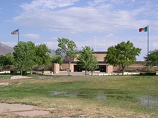
WChamizal National Memorial, located in El Paso, Texas, along the United States–Mexico international border, is a National Park Service site commemorating the peaceful settlement of the Chamizal boundary dispute.
 W
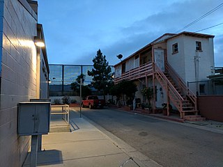
WChihuahuita is a neighborhood in El Paso, Texas. It has also been known as the "First Ward." It is considered the oldest neighborhood in the city. It has also suffered through extreme poverty in its history. It is currently on the Most Endangered Historic Places list as compiled by the National Trust for Historic Preservation. It is located on the border of the Rio Grande at the Mexico–United States border. For most of the twentieth century, the name Chihuahuita was used to refer to all of southern El Paso, often including El Segundo Barrio. In 1991, Chihuahuita was designated as a historic district by the city of El Paso.
 W
WDowntown El Paso is the central business district of El Paso, Texas.
 W
WEl Paso Street is located in downtown El Paso. El Paso Street leads to a vehicular and pedestrian bridge into Ciudad Juárez, México and is owned by the Texas Department of Transportation (TXDOT). The street is well known as a shopping area serving both Mexican and United States shoppers.
 W
WEl Paso–Juárez, also known as Juárez–El Paso, the Borderplex or Paso del Norte, is a transborder agglomeration, on the border between Mexico and the United States. The region is centered on two large cities: Ciudad Juárez, Chihuahua, Mexico and El Paso, Texas, U.S. Additionally, nearby Las Cruces, New Mexico, U.S. is sometimes included as part of the region, referred to as El Paso–Juárez–Las Cruces or El Paso–Juárez–Southern New Mexico. With over 2.7 million people, this binational region is the 2nd largest conurbation on the United States–Mexico border. The El Paso–Juárez region is the largest bilingual, binational work force in the Western Hemisphere.
 W
WEl Segundo Barrio is a historic Hispanic neighborhood in El Paso, Texas. It is one of the oldest neighborhoods in El Paso. It was one of the main ports of entry into the United States from Mexico for many years, and became known as the "other Ellis Island" as a result.
 W
WThe Franklin Mountains of Texas are a small range that extend from El Paso, Texas north into New Mexico. The Franklins were formed due to crustal extension related to the Cenozoic Rio Grande rift. Although the present topography of the range and adjoining basins is controlled by extension during rifting in the last 10 million years, faults within the range also record deformation during the Laramide orogeny, between 85 and 45 million years ago.
 W
WFranklin Mountains State Park is a Texas state park in El Paso, Texas, in the United States. Park headquarters are located at an elevation of 5,426 feet (1,654 m) with the highest peak reaching 7,192 feet (2,192 m). It is one of the largest urban parks in the nation lying completely within city limits, covering 24,247.56 acres (9,813 ha). Franklin Mountains State Park is open year-round for recreational hiking, mountain biking, picnicking and scenic driving and vistas.
 W
WThe Hueco Mountains are a range of mountains that rise in southern Otero County, New Mexico and extend 27 miles (43 km) south into Texas, generally along the El Paso–Hudspeth county line just east of the city of El Paso, Texas. The highest point of the range is the Cerro Alto Mountain 6,703 feet (2,043 m) in Hudspeth County.
 W
WKern Place is a historic neighborhood on the West side of El Paso, Texas. The neighborhood lies just east of the University of Texas at El Paso, and north of downtown. Kern is part of District 1 in the City of El Paso and currently represented by Peter Svarzbein. The neighborhood was created by Peter E. Kern, and once had an unusual gate marking the entrance. Madeline Park in the center of the neighborhood is named after Kern's daughter. Businesses and a small entertainment district border the eclectic housing featured in the neighborhood.
 W
WMcKelligon Canyon is the location of a 1,503-seat amphitheater located in El Paso, Texas, United States, where the play Viva El Paso! is presented. The amphitheater is also used for concerts, graduation ceremonies, and other special events. Adjacent is the 300-seat McKelligon Canyon Pavilion.
 W
WNorth Franklin Mountain is a mountain in the Franklin Mountains of El Paso, Texas, located in the Southwestern United States. North Franklin, at 7,192 feet (2,192 m), is the highest point in El Paso, and the 27th-highest mountain in the state of Texas. Surrounded by a state park and with a maintained trail leading to its summit, the mountain is a popular hiking destination.
 W
WNortheast El Paso is part of the city of El Paso, Texas and is located north of Central El Paso, and east of the Franklin Mountains. Its southern boundary is variously given as Fred Wilson Boulevard or Cassidy Road and Van Buren Avenue, and it extends northward to the New Mexico state line; some portions of this region lie outside the city limits, including parts of Franklin Mountains State Park and areas of Fort Bliss: the Logan area of Fort Bliss around Chapin High School and Castner Range, an old firing range northwest of Hondo Pass Avenue and Gateway South Boulevard. Development of Northeast El Paso, which had begun before the Second World War around the Logan area, started in earnest during the 1950s, when many homes were demolished in the process of the construction of Interstate 10. It is one of the more ethnically diverse areas of town due to a high concentration of enlisted military families. Northeast El Paso has historically not developed at a rate comparable to East El Paso and Northwest El Paso, but in recent years, it has seen an increase in development. It is expected that the population in Northeast El Paso will grow more rapidly as a result of the troop increase for Fort Bliss in the coming years. Northeast El Paso has gained recognition throughout the city for schools like Parkland, Irvin, Andress and Chapin because of their outstanding athletic programs.
 W
WSan Jacinto Plaza is a historic park located on the corner of Oregon and Mills in the heart of Downtown El Paso, Texas.
 W
WWest central El Paso is part of the city of El Paso, Texas, USA. The area is located north of Interstate 10 Highway and west of the Franklin Mountains. The University of Texas at El Paso is located in the heart of the area. It is part of the El Paso Independent School District.