 W
WAlbany, South Africa was a district in the Eastern Cape, South Africa. Grahamstown was traditionally the administrative capital, cultural centre and largest town of the Albany district.
 W
WThe Balfour Formation is a geological formation that is found in the Beaufort Group, a major geological group that forms part of the greater Karoo Supergroup in South Africa. The Balfour Formation is the uppermost formation of the Adelaide Subgroup which contains all the Late Permian-aged biozones of the Beaufort Group. Outcrops and exposures of the Balfour Formation are found from east of 24 degrees in the highest mountainous escarpments between Beaufort West and Fraserburg, but most notably in the Winterberg and Sneeuberg mountain ranges near Cradock, the Baviaanskloof river valley, Graaff-Reniet and Nieu Bethesda in the Eastern Cape, and in the southern Free State province.
 W
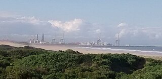
WThe Coega Industrial Development Zone (IDZ), established in 1999 and 11,500 ha in extent, is situated near Port Elizabeth in the Eastern Cape province of South Africa. The initiative is a multibillion-dollar industrial development complex customised for heavy, medium and light industries, and adjacent to a deepwater port, the Port of Ngqura. The Coega Development Corporation (CDC) is the developer and operator of the Coega IDZ and is responsible for the land side infrastructure, while the Transnet National Ports Authority develops the deep-water port facility, the Port of Ngqura.
 W
WThe Elliot Formation is a geological formation and forms part of the Stormberg Group, the uppermost geological group that comprises the greater Karoo Supergroup. Outcrops of the Elliot Formation have been found in the northern Eastern Cape, southern Free State, and in the eastern KwaZulu-Natal provinces of South Africa. Outcrops and exposures are also found in several localities in Lesotho such as Qacha's Neck, Hill Top, Quthing, and near the capital, Maseru. The Elliot Formation is further divided into the lower (LEF) and upper (UEF) Elliot formations to differentiate significant sedimentological differences between these layers. The LEF is dominantly Late Triassic (Norian-Rhaetian) in age while the UEF is mainly Early Jurassic (Hettangian) and is tentatively regarded to preserve a continental record of the Triassic-Jurassic boundary in southern Africa. This geological formation is named after the town of Elliot in the Eastern Cape, and its stratotype locality is located on the Barkly Pass, 9 km north of the town.
 W
WEmaMpondweni, which is Nguni for Mpondoland, is a natural region on the South African shores of the Indian Ocean. It is located in the coastal belt of the Eastern Cape province. Its territory is the former Mpondo Kingdom and the traditional region of the Mpondo people, one of the Nguni groups.
 W
WThe Abrahamskraal Formation is a geological formation and is found in numerous localities in the Northern Cape, Western Cape, and the Eastern Cape of South Africa. It is the lowermost formation of the Adelaide Subgroup of the Beaufort Group, a major geological group that forms part of the greater Karoo Supergroup. It represents the first fully terrestrial geological deposits of the Karoo Basin. Outcrops of the Abrahamskraal Formation are found from the small town Middelpos in its westernmost localities, then around Sutherland, the Moordenaarskaroo north of Laingsburg, Williston, Fraserburg, Leeu-Gamka, Loxton, and Victoria West in the Western Cape and Northern Cape. In the Eastern Cape outcrops are known from Rietbron, north of Klipplaat and Grahamstown, and also southwest of East London.
 W
WThe Bokkeveld Group is the second of the three main subdivisions of the Cape Supergroup in South Africa. It overlies the Table Mountain Group and underlies the Witteberg Group. The Bokkeveld Group rocks are considered to range between Lower Devonian (Lochkovian) to Middle Devonian (Givetian) in age.
WThe Teekloof Formation is a geological formation that forms part of the Beaufort Group, one of the five geological groups that comprises the Karoo Supergroup in South Africa. The Teekloof Formation is the uppermost formation of Adelaide Subgroup deposits West of 24ºE and contains Middle to Late Permian-aged deposits and four biozones of the Beaufort Group. It overlies the Abrahamskraal Formation. The Teekloof Formation does not underlie other units other than the younger Karoo dolerites and sills that relate to the emplacement of the Early Jurassic Drakensberg Group to the east. Outcrops and exposures of the Teekloof Formation range from Sutherland through the mountain escarpments between Fraserburg and Beaufort West. The northernmost localities of the Teekloof Formation are found by Loxton, Victoria West and Richmond.
 W
WThe Knysna-Amatole montane forests ecoregion, of the tropical and subtropical moist broadleaf forests biome, is in South Africa. It covers an Afromontane area of 3,100 square kilometres (1,200 sq mi) in the Eastern Cape and Western Cape provinces.
 W
WThe Kwazulu-Cape coastal forest mosaic is a subtropical moist broadleaf forest ecoregion of South Africa. It covers an area of 17,800 square kilometers (6,900 sq mi) in South Africa's Eastern Cape and KwaZulu-Natal provinces.
 W
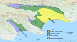
WThe Sundays River Formation is a geological formation found in the Eastern and Western Cape provinces in South Africa. It is the second youngest of the four formations found within the Uitenhage Group of the Algoa Basin, its type locality, and the only location where outcrops have been located. The Sundays River has been measured at a maximum thickness of 2,000 metres (6,600 ft).
 W
WThembuland, Afrikaans: Temboeland, is a natural region in the Eastern Cape province of South Africa. Its territory is the traditional region of the Thembu people, one of the sub-groups of the Xhosa nation.
 W
WThyspunt is a rocky stretch of coast approximately 12 km WNW of Cape Saint Francis in the Eastern Cape province of South Africa. It is just west of the beach Thysbaai and south-east of Oyster Bay. The point is near the popular surfing beach of Jeffreys Bay as well as the holiday town of St Francis Bay. It lies about 18 km SSW of the town of Humansdorp.
 W
WThe Uitenhage Group is one of three geological groups, which comprise the onshore and offshore post-Karoo middle to lower Upper Mesozoic geological rock units in South Africa. Stratigraphically, the Uitenhage Group overlies the Suurberg Group and is overlain by the Algoa Group. It contains four formations that range in age from late Early Jurassic and late Early Cretaceous in age.
 W
WThe Whitehill Formation, alternatively written as White Hill Formation and formerly known as White Band or Whitehill or White Hill Member, is a regional Early Permian geologic formation belonging to the Ecca Group in the southeastern ǁKaras Region of southeastern Namibia and Eastern, Northern and Western Cape provinces of South Africa.