 W
WAlatau or Ala-Too is a generic name for a number of mountain ranges in Central Asia, characterized by interleaving areas of vegetation, scattered rocks and snows.
 W
WThe Altai Mountains, also spelled Altay Mountains, are a mountain range in Central and East Asia, where Russia, China, Mongolia, and Kazakhstan come together, and where the rivers Irtysh and Ob have their headwaters. The massif merges with the Sayan Mountains in the northeast, and gradually becomes lower in the southeast, where it merges into the high plateau of the Gobi Desert. It spans from about 45° to 52° N and from about 84° to 99° E.
 W
WThe Chuya Alps are part of the Altay mountain range, straddling the border of Russia and Kazakhstan close to the region where their borders and those of China and Mongolia meet. They have an average altitude of about 9000 ft with summits ranging from 11,500 to 12,000 ft. There are about ten glaciers found on the northern part of their slopes. They are named after the Chuya River.
 W
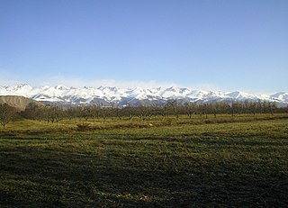
WThe Dzungarian Alatau is a mountain range that lies on the boundary of the Dzungaria region of China and the Zhetysu region of Kazakhstan. It has a length of 450 km (280 mi) and a maximum elevation of 4,464 m (14,646 ft).
 W
WThe Karatau or Qaratau is a mountain range located in southern Kazakhstan.
 W
WThe Kungey Alatau, also spelled Kungoy Ala-Too, and Kungey Alataw, is a mountain range, which forms the Northern Tien Shan with Zailiyskiy Alatau. The word "Alatau" or "Ala-too" means "variegated mountains", a designation indicating a pronounced high-altitude zone of mountains, partly white due to snow, partly dark on snowless areas. The word "Kungey" or "Kyungei" means "the side facing to the South".
 W
WThe Kyrgyz Ala-Too also known as Kyrgyz Alatau, Kyrgyz Range, and Alexander Range is a large range in the North Tien-Shan. It stretches for a total length of 454 km from the west-end of Issyk-Kul to the town Taraz in Kazakhstan. It runs in the east-west direction, separating Chuy Valley from Kochkor Valley, Suusamyr Valley, and Talas Valley. Talas Ala-Too Range adjoins the Kyrgyz Ala-Too in vicinity of Töö Ashuu Pass. The western part of Kyrgyz Ala-Too serves as a natural border between Kyrgyzstan and Kazakhstan.
 W
WMugodzhar Hills or Mugodzhar Range is a series of mountain ranges 275 miles (440 km) long in the Aktobe Region of northwestern Kazakhstan. They are considered to be a continuation of Ural Mountains and connected with Southern Ural by Guberlinskiy hillocks. They form the divide between the Caspian Sea and Aral Sea basins.
 W
WSouthern Ural - the south, the widest part of the Ural Mountains, stretches from the river Ufa to the Ural River. From the west and east of the Southern Ural is limited to the East European, West Siberian Plain and the steppes near Aral Sea and Caspian sea.
 W
WThe Talas Ala-Too or Alataw range is range of the Tian Shan mountains forming the southern and eastern border of Talas Region of Kyrgyzstan. Its western end extends into Kazakhstan, and its south-western end joins the Pskem Mountains and Ugam Range of Uzbekistan. Its eastern end joins the Kirgiz Alatau mountains. To the north is the Talas River valley, and, to the south, Jalal-Abad Region. The highest point is Mount Manas (4484m) near the Uzbek border. There are four major passes along the range. Ötmök pass is the road entrance from the east. The main road from Bishkek to Osh enters from the east over the Ala-Bel pass, passes through the Chychkan State Zoological Reserve and then turns south over another pass into Jalal-Abad province. The Kara-Buura pass (road) and Terek pass lead south into Jalal-Abad provinces.
 W
WThe Tarbagatai Mountains, literally: "range with marmots"); Chinese: 塔尔巴哈台山; pinyin: Tǎ'ěrbāhātái Shān; Kazakh: Тарбағатай жотасы, Tarbaǵataı jotasy) are a range of mountains located in the north-western parts of Xinjiang, China, and East Kazakhstan. The name of the mountain derived from Mongolian word: in Traditional Mongolian alphabet: Mongolian: ᠲᠠᠷᠪᠠᠭᠠ with suffix Mongolian: ᠲᠠᠢ.
 W
WThe Tian Shan, also known as the Tengri Tagh or Tengir-Too, meaning the Mountains of Heaven or the Heavenly Mountain, is a large system of mountain ranges located in Central Asia. The highest peak in the Tian Shan is Jengish Chokusu, at 7,439 metres (24,406 ft) high. Its lowest point is the Turpan Depression, which is 154 m (505 ft) below sea level.
 W
WIle Alatau, also spelt as Trans-Ili Alatau, etc., is a part of the Northern Tian Shan mountain system in Kazakhstan and Kyrgyzstan. It is the northernmost mountain range of Tian Shan stretching for about 350 km (220 mi) with a maximal elevation of 4,973 m (16,316 ft). The term "Alatau" refers to a kind of mountain. The range is bounded from the north by the Ili Depression of the Ili River, hence the name.
 W
WUgam Range is a mountain range in South Kazakhstan Region of Kazakhstan and Tashkent Region in Uzbekistan. It is part of Western Tian Shan. The range runs from northeast to southwest; in the northeast, it joins the Talas Alatau; in the southwest, it gradually flattens towards the valley of the Syr Darya. The total length of Ugam Range is approximately 100 kilometres (62 mi), the highest peaks are over 4,000 metres (13,000 ft). It marks the border between Kazakhstan and Uzbekistan.
 W
WThe Ural Mountains or simply the Urals, are a mountain range that runs approximately from north to south through western Russia, from the coast of the Arctic Ocean to the river Ural and northwestern Kazakhstan. The mountain range forms part of the conventional boundary between the continents of Europe and Asia. Vaygach Island and the islands of Novaya Zemlya form a further continuation of the chain to the north into the Arctic Ocean.