 W
WEl Eden Ecological Reserve is a non governmental organization Ecological Reserve in Quintana Roo, Mexico.
 W
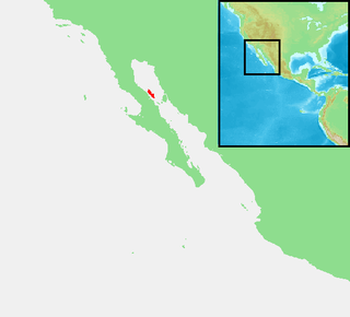
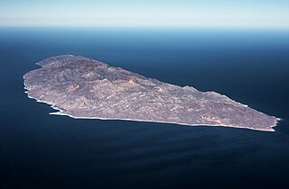
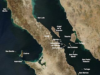
WIsla Ángel de la Guarda, also called Archangel Island, is a large island in the Gulf of California east of Bahía de los Ángeles in northwestern Mexico, separated from the Baja California Peninsula by the Canal de Ballenas. It is the second largest of the eleven Midriff Islands or Islas Grandes. It is part of the state of Baja California, located northwest of Tiburón Island. The island is uninhabited, and is a biological reserve called Isla Angel de la Guarda National Park. The island is part of the Mexicali municipality.
 W
WIsla Coronado, also known as “Smith Island” on some maps, is just off the eastern shoreline of Mexico's Baja California Peninsula, near Bahía de los Ángeles, in the Gulf of California. The island is approximately 7 kilometers long, and it is dominated by a volcano on its northern end. It is part of the Ensenada Municipality.
WIsla Coronados, is an island in the Gulf of California east of the Baja California Peninsula in Baja California Sur state, Mexico. The island is uninhabited and is part of the Loreto Municipality.
 W
WIsla Espíritu Santo is an island in the Gulf of California, off the Mexican state of Baja California Sur. It is separated from Isla Partida by a narrow canal.
WIsla Pitahaya is an island in Bahía Concepción near Playa Santispac, in Baja California Sur. The island's name is derived from the fact that the island has many tall pitahaya cacti that are clearly observable from afar. Isla Pitahaya also has a lighthouse. The southwest shore has a small white, sandy beach while the rest of the island is rocky. The island is about 1.5 miles (2.4 km) from Playa Santispac and 0.5 miles (0.80 km) from the nearest mainland shore.
 W
WIsla Cerralvo, as is commonly named, whose official name is Isla Jacques Cousteau, is an island located off the Cerralvo Canal coast near La Paz, Baja California Sur, Mexico.
 W
WMontague Island, known in Spanish as Isla Montague, is an island at the mouth of the Colorado River in the municipality of Mexicali, Baja California, Mexico, and is part of the Colorado River Delta and part of a broader region called the Salton Trough. It is about 32 km (20 mi) in length along its longest axis.
 W
WPlaya de Escobilla Sanctuary is a waterfront sanctuary for sea turtles in the Mexican state of Oaxaca, with an area of about 30 hectares. The sanctuary lies in Santa María Tonameca Municipality, between the towns of Puerto Escondido and Huatulco near the town of Mazunte. In order to protect the turtles, the beach is guarded during nesting season and is off-limits to tourists. However, during this season visitors can join overnight trips to observe the olive ridley turtles heaving themselves on shore to lay their eggs. These trips help support the local economy, and must be arranged in advance through the Centro Mexicano de la Tortuga.
 W
WSan Ignacio Lagoon is a lagoon located in Mulegé Municipality of the Mexican state of Baja California Sur, 59 kilometres (37 mi) from San Ignacio, Mexico and Highway 1. It is one of the winter sanctuaries of the eastern Pacific gray whales.
 W
WSan Pedro Nolasco Island, sometimes called Seal Island, is a small and rugged Mexican island in the Gulf of California. It is 4.2 km long by 1 km wide, and lies 15 km from the nearest point of the Mexican coast and about 28 km west of the resort town of San Carlos on the coast of the Sonoran Desert. The island is protected as a nature reserve and its coastal waters are well known as a sport fishing and diving site.
 W
WThe Sierra del Carmen, also called the Sierra Maderas del Carmen, is a northern finger of the Sierra Madre Oriental in the state of Coahuila, Mexico. The Sierra begins at the Rio Grande at Big Bend National Park and extends southeast for about 45 miles (72 km), reaching a maximum elevation of 8,920 feet (2,720 m). Part of the Sierra del Carmen is protected in the Maderas del Carmen Biosphere Reserve as part of a bi-national effort to conserve a large portion of the Chihuahua Desert in Mexico and Texas.
 W
WTiburón Island is the largest island in the Gulf of California and the largest island in Mexico, with an area of 1,201 square kilometres (464 sq mi). It was made a nature reserve in 1963 by President Adolfo López Mateos.
WIsla Tortuga is an island in the Gulf of California, created relatively recently in geologic terms by the volcanism associated with the East Pacific Rise. It lies east-northeast of the city of Santa Rosalía, in Mulegé Municipality. It has a surface area of 11.374 km².
 W
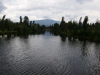
WXochimilco Ecological Park and Plant Market is a natural reserve or park, with a 13-hectare (32-acre) plant market, the largest in Latin America. The park and market are located in the southern Mexico City borough of Xochimilco, about 23 km south of the historic center of the city. The park was designed by Mario Schjetnan. The park was inaugurated in 1993, on chinampas which had been previously declared as part of a World Heritage site. However, the area's ecology was badly degraded, and the park was established in order to revitalize and preserve the ecosystem. Success has been mixed. While much of the wetlands have been recharged, pollution and illegal settlements in the area remain as threats. As the park needs to be self-sustaining economically, there are a number of ways that the park raises money. One of the best known of these is the Xochimilco or Cuemanco Plant Market, which rents stalls to ornamental plant producers/sellers near the main entrance of the park.