 W
WA separation barrier or separation wall is a barrier, wall or fence, constructed to limit the movement of people across a certain line or border, or to separate peoples or cultures. A separation barrier that runs along an internationally recognized border is known as a border barrier.
WThe Berlin Wall was a guarded concrete barrier that physically and ideologically divided Berlin from 1961 to 1989. Construction of the wall was commenced by the German Democratic Republic on 13 August 1961. The Wall cut off West Berlin from surrounding East Germany, including East Berlin. The barrier included guard towers placed along large concrete walls, accompanied by a wide area that contained anti-vehicle trenches, beds of nails, and other defenses. The Eastern Bloc portrayed the Wall as protecting its population from fascist elements conspiring to prevent the "will of the people" from building a socialist state in East Germany.
 W
WThe Ceuta border fence forms part of the Morocco–Spain border at Ceuta, a city on the North African coast. Constructed by Spain, its purpose is to prevent smuggling and to stop migrants from entering Europe. Morocco objected to the construction of the barrier since it does not recognize Spanish sovereignty in Ceuta.
 W
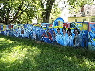
WThe Detroit Eight Mile Wall, also referred to as Detroit's Wailing Wall, Berlin Wall or The Birwood Wall, is a one-foot-thick (0.30 m), six-foot-high (1.8 m) separation wall that stretches about 1⁄2 mile (0.80 km) in length. 1 foot is buried in the ground and the remaining 5 feet is visible to the community. It was constructed in 1941 to physically separate Black and white homeowners on the sole basis of race. The wall no longer serves to racially segregate homeowners and, as of 1971, both sides of the barrier have been predominately Black.
 W
WThe Egypt–Gaza barrier refers to the steel border barrier along the border between Egypt and the Gaza Strip. Because it is essentially splitting the city of Rafah, the steel barrier is also referred as a separation wall.
 W
WThe Israeli West Bank barrier or wall or fence is a separation barrier in the West Bank or along the Green Line. Israel calls it a security barrier against terrorism, while Palestinians call it a racial segregation or apartheid wall. At a total length of 708 kilometres (440 mi) upon completion, the route traced by the barrier is more than double the length of the Green Line, with 15% of the barrier's length running along the Green Line or inside Israel, while the remaining 85% is inside the West Bank going up to 18 kilometres (11 mi) from the West Bank border, isolating about 9% of the land and 25,000 Palestinians from the rest of West Bank.
 W
WThe Line of Control (LoC) is a military control line between the Indian and Pakistani controlled parts of the former princely state of Jammu and Kashmir—a line which does not constitute a legally recognized international boundary, but serves as the de facto border. Originally known as the Cease-fire Line, it was redesignated as the Line of Control following the Simla Agreement, which was signed on 3 July 1972. The part of the former princely state that is under Indian control is divided into the union territories of Jammu and Kashmir and Ladakh, while the Pakistani-controlled part is divided into Azad Jammu and Kashmir and Gilgit–Baltistan. The northernmost point of the Line of Control is known as NJ9842. The India–Pakistan border continues from the southernmost point on the LoC.
 W
WThe Maginot Line, named after the French Minister of War André Maginot, is a line of concrete fortifications, obstacles, and weapon installations built by France in the 1930s to deter invasion by Germany and force them to move around the fortifications.
 W
WThe Moroccan Western Sahara Wall or Berm is an approximately 2,700 km (1,700 mi) long structure, mostly a sand wall, running through Western Sahara and the southwestern portion of Morocco. It separates the Moroccan areas on the west from the Polisario-controlled areas on the east.
 W
WThe Line of Contact separates the Armenian forces and the Azerbaijan Armed Forces in the Nagorno-Karabakh conflict. It was formed in the aftermath of the May 1994 ceasefire that ended the First Nagorno-Karabakh War (1988–94). The mountain range of Murovdag is the northern part of the line of contact and is essentially a natural border between the two forces. The length of the line of contact was between 180 kilometres (110 mi) and 200 kilometres (120 mi) until 2020. It was slightly changed for the first time since the 1994 ceasefire during the Nagorno-Karabakh conflict of 2016, and the current line of contact since the 2020 ceasefire following Second Nagorno-Karabakh War remains unclear.
 W
WThe Panama Canal fence was a barrier dividing the Canal Zone, which was controlled by the United States, from the Republic of Panama. In 1960, it was constructed concurrently with the widening of the adjacent roadway and the construction of the Thatcher Ferry Bridge.
 W
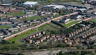
WThe peace lines or peace walls are a series of separation barriers in Northern Ireland that separate predominantly republican and nationalist Catholic neighbourhoods from predominantly loyalist and unionist Protestant neighbourhoods. They have been built at urban interface areas in Belfast, Derry, Portadown and elsewhere. The stated purpose of the peace lines is to minimise inter-communal violence between Catholics and Protestants.
 W
WThe Syria–Turkey barrier is a border wall and fence under construction along the Syria–Turkey border aimed at preventing illegal crossings and smuggling from Syria into Turkey.
 W
WThe United Nations Buffer Zone in Cyprus is a demilitarized zone, patrolled by the United Nations Peacekeeping Force in Cyprus (UNFICYP), that was established in 1964 and extended in 1974 after the ceasefire of 16 August 1974, following the Turkish invasion of Cyprus, and the de facto partition of the island into the area controlled by the Republic of Cyprus and the unofficial Turkish Republic of Northern Cyprus in the North. The zone, also known as the Green Line, stretches for 180 kilometres from Paralimni in the east to Kato Pyrgos in the west, where a separate section surrounds Kokkina.
 W
W"Wall of Shame" is a phrase that is most commonly associated with the Berlin Wall. In this context, the phrase was coined by Willy Brandt, and it was used by the government of West Berlin, and later popularized in the English-speaking world and elsewhere from the beginning of the 1960s. Inspired by its usage in reference to the Berlin Wall, the term has later been used more widely.