 W
WThe Southern Zanzibar-Inhambane coastal forest mosaic, also known as the Southern Swahili coastal forests and woodlands, is a tropical moist broadleaf forest ecoregion of eastern Africa. It is a southern variation of Northern Zanzibar-Inhambane coastal forest mosaic. The ecoregion supports habitats of forest, savanna and swamps. The southern portion of the ecoregion is not as well studied due to the 1977-1992 civil war in Mozambique.
 W
WThe Bazaruto Archipelago is a group of six islands in Mozambique, near the mainland city of Vilankulo. It comprises the islands of Bazaruto, Benguerra, Magaruque, Banque, Santa Carolina and Shell. Nyati Island locates in further south.
 W
WThe Cheringoma Plateau is a low plateau in Sofala Province of Mozambique. It lies mostly within Cheringoma, Muanza, and Marromeu districts.
WMount Chiperone is a mountain in northern Mozambique.
 W
WThe 950 hectares Chirinda Forest Botanical Reserve is situated on the slopes of Mount Selinda, 30 km south of Chipinge, in the Chipinge Highlands of Manicaland, Zimbabwe, and is administered by the Forestry Commission. The reserve is situated at between 900 and 1,200 m in altitude, and receives some 1,370 mm (54 in) to 1,466 mm (57.7 in) of annual rainfall. 606 hectares of its higher levels, above 1,076 m (3,530 ft), is covered by moist evergreen forest, specifically Zanzibar-Inhambane transitional rain forest, of which it represents the southernmost occurrence. The headwaters of three streams, namely the Zona, Chinyika and Musangazi, drain the two broad highlands which it encloses. The boundaries of the reserve are not strictly enforced, so that cattle grazing and plant harvesting are ongoing. The reserve is surrounded by communal settlements, commercial timber plantations and small-scale commercial farming units. The naturalist Charles Swynnerton was appointed manager of the nearby Gungunyana farm in 1900, and a number of plant, bird and insect names commemorate his collecting activities of the next two decades. Chirinda means "lookout" or "vantage point" in the chiNdau language, or perhaps "place of refuge".
WMount Inago, also known as Serra Inago, is a mountain in northern Mozambique.
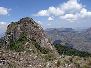
WMount Lico is an inselberg mountain in the Alto Molocue District of Zambezia Province in northern Mozambique, most notable for its old-growth rainforest and its lack of penetration by humans. Mount Lico is approximately 1,100 metres above sea level but is distinctive in having sheer rock walls of up to 700 metres above the surrounding countryside which have prevented almost all human intrusion. The forest on top, within a volcanic crater, covers only about 30 hectares.
 W
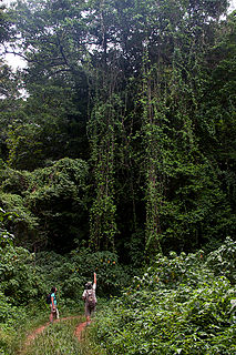
WMount Mabu is a mountain in northern Mozambique, famous for its old-growth rain forest. Mount Mabu is approximately 1,700 metres high and the forest covers about 7,000 hectares. While well known locally, the Mount Mabu forest and its extremely diverse wildlife were unknown to plant and animal scientists until 2005. It was visited after browsing Google Earth in 2005 by a team of scientitsts from the Mulanje Mountain Conservation Trust (MMCT) and several Ornithologists, and later in 2008 by scientists from Kew Royal Botanic Gardens; by browsing Google Earth's satellite view to look for potential unknown wildlife hotspots in Africa. It is frequently referred to as the "Google Forest".
WThe Makonde Plateau, also known as the Newala Plateau, is a plateau in southeastern Tanzania. It is mostly within Mtwara Region, with the northeast corner in Lindi Region.
 W
WThe 144 km2 Moribane Forest Reserve which was proclaimed in 1957, is a natural forest in the buffer zone of the 640 km2 Chimanimani National Reserve, and is situated 24 km north of Dombé, in Sussundenga District of central Mozambique. The mid to low-altitude tropical rain forest covers hilly country, from 400 to 550 metres in altitude, on the eastern verges of the largest southern African forest of this type, altogether 820 km2 in extent. It can be reached using public transport from Sussundenga.
WMount Morrumbala, also known as Mount Tembe, is a mountain in Morrumbala District of Zambezia Province in central Mozambique.
 W
WMount Namuli is the second highest mountain in Mozambique and the highest in the Province of Zambezia. It is 2,420 m (7,940 ft) high and was measured, surveyed and described in 1886 by Henry Edward O'Neill, the British consul in Mozambique. The Namuli massif consists of a level plateau with the granite dome of Mount Namuli above. The area was historically clad in tropical rainforest and is an important biodiversity hotspot with many endemic species of animals and plants. The lower slopes are now mainly used for the cultivation of tea and the middle slopes for other agricultural purposes, with indigenous forest now mostly restricted to the higher parts and corridors along water courses.
 W
WMount Ribáuè, also known as Monte Ribáuè, is a mountain in Nampula Province of Mozambique.
 W
WThe Rondo Plateau, also known as the Muera Plateau, is a high and extensive massif in the Lindi Region of southeastern of Tanzania. A portion of the plateau is protected by the Rondo Forest Reserve. It is one of a group of dissected plateaus lying between the Mbwemburu and Lukuledi rivers. It is approximately 60 km inland from Lindi, and is situated 15 km north of the Masasi road. It was revealed as an important biodiversity site in studies conducted since the 1980s.
WMount Tumbine is a mountain in northern Mozambique.