 W
WCalima Lake is the largest artificial lake in Colombia and the American continent with an area of 70 km2. It is located in the municipality of Darién in the Valle del Cauca Department.
 W
WThe Cauca Valley montane forests (NT0109) is an ecoregion in western Colombia. It covers the sides of the Cauca Valley, which runs from south to north between the Central and Western Ranges (cordilleras) of the Colombian Andes. The ecoregion is home to very diverse fauna and flora, due in part to its varied elevations and climates, in part to its position near the isthmus of Panama, the route along which North American species invaded South America and then diversified as they moved to the upper parts of the Andes. Little of the original habitat remains at lower levels, but higher up there are sizeable blocks of forest, some of which ate protected.
 W
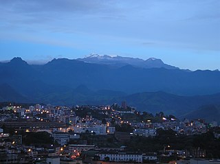
WFarallones de Cali is a cluster of mountains in the West Andes of Colombia. It is located west of the city of Cali and gives rise to many of the rivers that provide water and electricity to Cali. The PNN Farallones de Cali encompasses 150,000 ha (580 sq mi) in the mountains as well as much of the Pacific slope and is an area of very high biodiversity. The average temperature ranges from 25 °C (77 °F) in the tropical foothills to 5 °C (41 °F) in the páramo.
WThe Argelia Fault is an inactive dextral oblique thrust fault in the departments of Risaralda and Valle del Cauca in Colombia. The fault has a total length of 59.4 kilometres (36.9 mi) and runs along an average north to south strike of 014.5 ± 18 in the Western Ranges of the Colombian Andes.
WThe El Tambor Fault is an inactive dextral oblique thrust fault in the departments of Cauca and Valle del Cauca in Colombia. The fault has a total length of 117.5 kilometres (73.0 mi) and runs along an average northeast to southwest strike of 026.1 ± 09 to the west of the Western Ranges of the Colombian Andes.
WThe Garrapatas Fault (Zone) is an inactive dextral oblique thrust fault in the departments of Chocó and Valle del Cauca in Colombia. The fault has a total length of 138 kilometres (86 mi) and is crescent-shaped, running along an average east-northeast to west-southwest strike of 060.8 ± 14 in the Western Ranges of the Colombian Andes.
WThe Naya-Micay Fault is a dextral oblique thrust fault in the departments of Cauca and Valle del Cauca in Colombia. The fault has a total length of 158.2 kilometres (98.3 mi) and runs along an average northeast to southwest strike of 034.1 ± 12 in the Tumaco Basin along the Pacific Coast of Colombia.
WThe Paraíso Fault or Palmira-Buga Fault is a thrust fault with minor dextral lateral movement in the department of Valle del Cauca in southwestern Colombia. The fault is part of the megaregional Romeral Fault System and has a total length of 35.3 kilometres (21.9 mi) and runs along an average north-northwest to south-southeast strike of 012.5 ± 3 in the Cauca Basin and the Central Ranges of the Colombian Andes.
WThe Toro Fault is a sinistral strike-slip fault in the departments of Valle del Cauca and Risaralda in western Colombia. The fault has a total length of 61.9 kilometres (38.5 mi) and runs along an average north to south strike of 006.6 ± 8 in the Western Ranges of the Colombian Andes.
 W
WThe Laguna de Sonso Nature Reserve is located in the Valle del Cauca Department of Colombia. It contains the last extensive remnant of original natural wetland remaining in the Cauca River Valley in western Colombia, and was declared a nature reserve in October 1978. It comprises a series of marshes and lagoons on the east bank of the Cauca River, between the municipalities of Buga, Yotoco and Guacari. It has an area of 2,045 ha (7.90 sq mi), lying at an altitude of 935 m (3,068 ft). The wetlands are affected by the introduced water hyacinth. The reserve has been designated as a protected Ramsar site since 2017.
 W
WThe Las Hermosas National Natural Park is a national park located in the Valle del Cauca and Tolima departments, at the highest elevation of Cordillera Central range in the Andean Region of Colombia. Its main feature is probably the wetlands and 387 glacial lakes.
 W
WThe Malpelo Plate is a small tectonic plate (microplate) located off the coasts west of Ecuador and Colombia. It is the 57th plate to be identified. It is named after Malpelo Island, the only emerged part of the plate. It is bounded on the west by the Cocos Plate, on the south by the Nazca Plate, on the east by the North Andes Plate, and on the north by the Coiba Plate, separated by the Coiba Transform Fault (CTF). This microplate was previously assumed to be part of the Nazca Plate. The Malpelo Plate borders three major faults of Pacific Colombia, the north to south striking Bahía Solano Fault in the north and the Naya-Micay and Remolino-El Charco Faults in the south.
WThe Romeral Fault System is a megaregional system of major parallel and anastomosing faults in the Central Ranges of the Colombian Andes and the Cauca, Amagá, and Sinú-San Jacinto Basins. The system spans across ten departments of Colombia, from northeast to south Bolívar, Sucre, Córdoba, Antioquia, Caldas, Risaralda, Quindío, Valle del Cauca, Cauca and Nariño. The fault zone extends into Ecuador where it is known as the Peltetec Fault System. The in detail described part of the Romeral Fault System south of Córdoba has a total length of 697.4 kilometres (433.3 mi) with a cumulative length of 1,787.9 kilometres (1,110.9 mi) and runs along an average north to south strike of 017.6 ± 16, cross-cutting the central-western portion of Colombia.
WThe Caribbean Terrane is one of the geological provinces (terranes) of Colombia. The terrane, dating to the Late Cretaceous, is situated on the North Andes Plate and borders the La Guajira, Chibcha and underlying Tahamí Terrane along the regional Bucaramanga-Santa Marta Fault. The terrane overlies the Tahamí, Arquía and Quebradagrande Terranes along the Romeral Fault System.
WThe Tahamí or Tahamí-Panzenú Terrane is one of the geological provinces (terranes) of Colombia. The terrane, dating to the Permo-Triassic, is situated on the North Andes Plate. The contact with the Chibcha, Arquía and Quebradagrande Terranes is formed by the megaregional Romeral Fault System. A tiny terrane is located at the contact with the Quebradagrande Terrane; Anacona Terrane.
 W
WUramba Bahía Málaga National Natural Park, is one of the newest Colombian national parks and a popular ecotourism destination. It is located in and around Málaga Bay on the Colombian Pacific coast in the municipality of Buenaventura, Valle del Cauca, Colombia. It is an area of high biodiversity and a favorite spot for reproducing humpback whales, making this area a popular whale watching destination. Most of natural area is pristine with the exception of the areas around a few small towns like Juanchaco, Ladrilleros, and La Barra, as well as a Colombian naval base. The national park was created in 2010 and is Colombia's 56th national natural park.