 W
WBroomhouse is a district of Edinburgh, Scotland. Although on the lands of Old Saughton, its name is adopted from an estate which lay to the north of the Edinburgh and Glasgow Railway. The earliest recorded versions of the name (c.1600) were variations on Brum(e)hous. It mainly comprises a low-rise council housing estate built between 1947 and 1950. It borders on Parkhead, Sighthill, and Saughton Mains. The arterial route of Calder Road (A71) passes to the south.
 W
WBurdiehouse is an area in the south east of Edinburgh, Scotland, near Gilmerton and Southhouse. Its name is often said to be a corruption of Bordeaux, as a result of settlement in the area by French immigrants associated with Mary, Queen of Scots, but this is by no means certain.
 W
WCables Wynd House, better known as the Leith Banana Flats or as the Banana Block because of its curved shape, is a nine-storey local authority housing block in Leith, Edinburgh. The building, in fact, has ten storeys. The ground floor is called Cables Wynd and the nine floors above constitute Cables Wynd House. This often leads to confusion in postal and other services. Communal heating and other energy measures have recently been installed by City of Edinburgh Council.
 W
WThe Calders are a mainly residential part of Sighthill, in Edinburgh, Scotland. They are sometimes considered to be part of Wester Hailes or Sighthill. They are not to be confused with the Calders of West Lothian, aka West Calder, Mid Calder and East Calder, three separate villages. The Union Canal goes by here into the city. The Calders also contains the Wester Hailes Education Centre. The bulk of the housing stock is council owned, and the area contains some of the remaining high rises in Edinburgh. The majority of the other buildings are four storeys high, with a small percentage two storey, all of which were built in the late 1960s and early 1970s. Before they were built, the area contained prewar prefabs.
 W
WClermiston is a suburb of Edinburgh, Scotland, to the west of the city and to the immediate north of Corstorphine, on the western slopes of Corstorphine Hill. Clermiston estate, built in 1954, was part of a major 1950s house-building programme to tackle overcrowding in Leith and Gorgie. The area is now home to more than 20,000 people, and abuts onto Drumbrae, Clerwood and Corstorphine.
 W
WClovenstone is a neighbourhood in southwestern Edinburgh, Scotland. It is adjacent to Wester Hailes and the A720 road.
 W
WThe colony houses of Edinburgh were built between 1850 and 1910 as homes for artisans and skilled working-class families by philanthropic model dwellings companies. The first development was the Pilrig Model Buildings, near Leith Walk. Later developments across the city were built by the Edinburgh Cooperative Building Company Limited, founded in 1861. The founders of this company were influenced by the Reverend Dr. James Begg and the Reverend Dr. Thomas Chalmers, ministers of the Free Church of Scotland, who campaigned to improve the housing conditions of the poor.
 W
WCraigmillar, from the Gaelic Creag Maol Ard, meaning 'High Bare Rock', is an area of Edinburgh, Scotland, about 3 miles (4.8 km) south east of the city centre, with Duddingston to the north and Newcraighall to the east.
 W
WDumbiedykes is a residential area in the centre of Edinburgh, Scotland, dominated by the housing scheme of the same name.
 W
WEast Pilton is a housing scheme in the north of Edinburgh, Scotland. It is located north of Ferry Road, west of Boswall, south of Royston Mains and Wardieburn and east of West Pilton. East Pilton is generally considered to be part of the Granton area.
 W
WGreendykes is a suburb of Edinburgh, the capital of Scotland. It is a fairly large council scheme, which consists mostly of low-rise flats but also houses two 14 storey tower blocks. It is sometimes considered to be part of Craigmillar, areas such as Niddrie, Niddrie Mains and Newcraighall are also situated nearby. Affordable housing is being provided through a joint venture known as PARClife between the city council and EDI, a private company 100% owned by the Council. Greendykes was ranked as the 4th most deprived area in Scotland in the recent Scottish Index of Multiple Deprivation 2006.
 W
WMoredun is a district in the south-east of Edinburgh, the capital of Scotland. It is east of Liberton, while Craigour is situated just to its north.
 W
WOxgangs is a suburb in the south-west of Edinburgh, Scotland. It is named for an oxgang, an ancient Scottish land measure.
 W
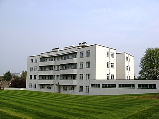
WRavelston Garden is a 1930s Art Deco development of residential buildings in the suburb of Ravelston in Edinburgh, the capital of Scotland.
 W
WSighthill is a suburb in the west of Edinburgh, Scotland.
 W
WWester Hailes is an area in the south west of Edinburgh, Scotland.