 W
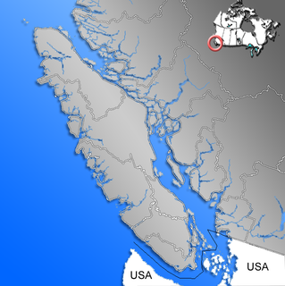
WAlberni Inlet is a long, narrow inlet in Vancouver Island, British Columbia, Canada, that stretches from the Pacific Ocean at Barkley Sound about 40 km (25 mi) inland terminating at Port Alberni. It was named by the Spanish explorer Francisco de Eliza after Pedro de Alberni, Captain of the Free Company of Volunteers of Catalonia who was appointed in the Spanish fort in Nootka Sound from 1790 to 1792. The inlet includes traditional territories of the Ucluelet, Uchucklesaht, Huu-ay-aht, Hupacasath, and Tseshaht peoples, who are part of the Nuu-chah-nulth Tribal Council people.
 W
WDella Falls is a waterfall located within Strathcona Provincial Park on Vancouver Island in British Columbia, Canada. With a total height of 440 m (1,440 ft), it ranks as the 16th tallest confirmed waterfall in Canada and the second tallest on Vancouver Island after Kiwi Falls in Schoen Lake Provincial Park.
 W
WFlores Island is a small island in Clayoquot Sound, off the west coast of Vancouver Island, British Columbia, Canada.
 W
WHorne Lake Caves Provincial Park is a provincial park on Vancouver Island in British Columbia, Canada. Its principal function is the protection, management, and recreational use of several caves collectively known as the Horne Lake Caves.
 W
WThe Insular Mountains are a range of mountains in the Pacific Coast Ranges on the Coast of British Columbia, Canada, comprising the Vancouver Island Ranges and Queen Charlotte Mountains. The Insular Mountains are rugged, particularly on Vancouver Island where peaks in Strathcona Provincial Park rise to elevations of more than 2,000 m (6,562 ft). The highest of these mountains is Golden Hinde on Vancouver Island, which rises to 2,196.818 m (7,207 ft).
 W
WJohnstone Strait is a 110 km (68 mi) channel along the north east coast of Vancouver Island in British Columbia, Canada. Opposite the Vancouver Island coast, running north to south, are Hanson Island, West Cracroft Island, the mainland British Columbia Coast, Hardwicke Island, West Thurlow Island and East Thurlow Island. At that point, the strait meets Discovery Passage which connects to Georgia Strait.
 W
WLizard Pond is a lake located on Vancouver Island, Canada, south east of Hiwatchas Mountain.
 W
WMeares Island is one of the many islands surrounding the Village of Tofino, British Columbia, Canada. Its name was given in 1862 by George Henry Richards, captain of HMS Hecate, in honor of John Meares. The island is located in the Clayoquot Sound region and is the location of Opitsat, the main village of the Tla-o-qui-aht First Nations, and was the location of Fort Defiance, a short-lived American fur-trading post founded by Captain Robert Gray.
 W
WMuchalat Inlet is an oceanographic/geographical region on the western coast of Vancouver Island, British Columbia, Canada. Muchalat Inlet extends 55 km (34 mi) from Nootka Sound to the east, terminating at Muchalat Bay. Located broadly south of Gold River, British Columbia, the area borders Mowachaht/Muchalaht First Nations reserve lands. The inlet is somewhat under-researched, with a complex runoff/renewal cycle supported by drainage from mountain terrain in the surrounding region. The inlet's maximum depth is 380 m (1,250 ft) and serves as a staging area for log exports, fishing, a ferry, and seasonal tourism and sporting activities. “Muchalat” is the current conventional spelling for mapping purposes, distinct from the current English spelling of the Muchalaht First Nations band for which it is named.
 W
WNeroutsos Inlet is an inlet on the north end of Vancouver Island, off of Quatsino Sound.
 W
WPatricia Bay is a body of salt water that extends east from Saanich Inlet and forms part of the shoreline of North Saanich, British Columbia. It lies due west of Victoria International Airport. A municipal park covers most of its eastern shore except at the southern end, which is home to a Canadian Coast Guard base, a seaplane port known as Victoria Airport Water Aerodrome, and two Canadian Government research facilities – the Institute of Ocean Sciences and GSC Pacific Sidney.
 W
WSaanich Inlet is a body of salt water that lies between the Saanich Peninsula and the Malahat highlands of Vancouver Island, British Columbia, Canada. Located just northwest of Victoria, the inlet is 25 km (16 mi) long, has a surface area of 67 km2 (26 sq mi), and its maximum depth is 226 m (741 ft). It extends from Satellite Channel in the north to Squally Reach and Finlayson Arm in the south. The only major tributary feeding the inlet is the Goldstream River.
 W
WThe San Juan Valley is a small valley located in the Capital Regional District of Vancouver Island in British Columbia, Canada.
 W
WThe Strait of Georgia or the Georgia Strait is an arm of the Salish Sea between Vancouver Island and the extreme southwestern mainland coast of British Columbia, Canada and the extreme northwestern mainland coast of Washington, United States. It is approximately 240 kilometres (150 mi) long and varies in width from 20 to 58 kilometres. Along with the Strait of Juan de Fuca and Puget Sound, it is a constituent part of the Salish Sea.
 W
WThe Strait of Juan de Fuca is a body of water about 96 miles long that is the Salish Sea's outlet to the Pacific Ocean. The international boundary between Canada and the United States runs down the centre of the Strait.
 W
WMount Washington is a mountain on the eastern edge of the Vancouver Island Ranges of British Columbia and the site of the popular Mount Washington Alpine Resort. It is located approximately 25 km (16 mi) from the Comox Valley.