A U.S. National Marine Sanctuary is a zone within United States waters where the marine environment enjoys special protection. The program began in 1972 in response to public concern about the plight of marine ecosystems.
 W
WThe Channel Islands National Marine Sanctuary is a sanctuary off the Pacific coast of Southern California. The National Marine Sanctuary program is administered by the National Oceanic and Atmospheric Administration.
 W
WCordell Bank National Marine Sanctuary is a marine sanctuary located off the coast of California. It protects an area of 1,286 sq mi (3,331 km2) of marine wildlife. The administrative center of the sanctuary is on an offshore granite outcrop 4.5 sq mi (12 km2) by 9.5 sq mi (25 km2), located on the continental shelf off of California. The outcrop is, at its closest, 6 mi (10 km) from the sanctuary itself.
 W
WThe Florida Keys National Marine Sanctuary is a U.S. National Marine Sanctuary in the Florida Keys. It includes the Florida Reef, the only barrier coral reef in North America and the third-largest coral barrier reef in the world. It also has extensive mangrove forest and seagrass fields. The Florida Keys National Marine Sanctuary, designated in 1990, is the ninth national marine sanctuary to be established in a system that comprises 13 sanctuaries and two marine national monuments. The Florida Keys National Marine Sanctuary protects approximately 2,900 square nautical miles of coastal and ocean waters from the estuarine waters of south Florida along the Florida Keys archipelago, encompassing more than 1,700 islands, out to the Dry Tortugas National Park, reaching into the Atlantic Ocean, Florida Bay and the Gulf of Mexico.
 W
WThe Flower Garden Banks National Marine Sanctuary is a U.S. National Marine Sanctuary located 100 nautical miles offshore of Galveston, Texas in the northwestern Gulf of Mexico.
 W
WGray's Reef National Marine Sanctuary is one of the largest near shore live-bottom reefs in the southeastern United States. The sanctuary, designated in January 1981, is located 19 miles (31 km) off Sapelo Island, Georgia, and is one of 14 marine sanctuaries and monuments that make up the U.S. National Marine Sanctuary System.
 W
WThe Greater Farallones National Marine Sanctuary protects the wildlife, habitats, and cultural resources of one of the most diverse and bountiful marine environments in the world, an area of 3,295 square miles off the northern and central California coast. The waters within Greater Farallones National Marine Sanctuary are part of a nationally significant marine ecosystem, and support an abundance of life, including many threatened or endangered species.
 W
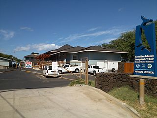
WThe Hawaiian Islands Humpback Whale National Marine Sanctuary is one of the world's most important whale habitats, hosting thousands of humpbacks each winter.
 W
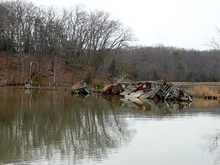
WMallows Bay is a small bay on the Maryland side of the Potomac River in Charles County, Maryland, United States. The bay is the location of what is regarded as the "largest shipwreck fleet in the Western Hemisphere" and is described as a "ship graveyard."
 W
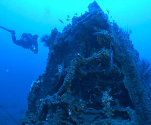
WMonitor National Marine Sanctuary is the site of the wreck of the USS Monitor, one of the most famous shipwrecks in U.S. history. It was designated as the country's first national marine sanctuary on January 30, 1975, and is one of only two of the sixteen national marine sanctuaries created to protect a cultural resource rather than a natural resource. The sanctuary comprises a column of water 1 nautical mile (1.9 km) in diameter extending from the ocean’s surface to the seabed around the wreck of the Civil War ironclad, which lies 16 nautical miles (30 km) south-southeast of Cape Hatteras, North Carolina. Average water depth in the sanctuary is 230 feet (70 m). Since its sinking in 1862, the Monitor has become an artificial reef attracting numerous fish species, including amberjack, black sea-bass, oyster toadfish and great barracuda.
 W
WThe Monterey Bay National Marine Sanctuary (MBNMS) is a US Federally protected marine area offshore of California's Big Sur and central coast. It is the largest US national marine sanctuary and has a shoreline length of 276 miles (444 km) stretching from just north of the Golden Gate Bridge at San Francisco to Cambria in San Luis Obispo County. Supporting one of the world’s most diverse marine ecosystems, it is home to numerous mammals, seabirds, fishes, invertebrates and plants in a remarkably productive coastal environment. The MBNMS was established in 1992 for the purpose of resource protection, research, education, and public use.
 W
WThe National Marine Sanctuary of American Samoa is a national marine sanctuary in American Samoa. It is the smallest, yet one of the most important, marine sanctuaries as it is home to more fish and marine mammals than any other marine sanctuary. It also provides a natural food source for sharks and other predators of the ocean.
 W
WThe Papahānaumokuākea Marine National Monument is a World Heritage listed U.S. National Monument encompassing 583,000 square miles (1,510,000 km2) of ocean waters, including ten islands and atolls of the Northwestern Hawaiian Islands. Created in June 2006 with 140,000 square miles (360,000 km2), it was expanded in August 2016 by moving its border to the limit of the exclusive economic zone, making it one of the world's largest protected areas. It is internationally known for its cultural and natural values as follows: "The area has deep cosmological and traditional significance for living Native Hawaiian culture, as an ancestral environment, as an embodiment of the Hawaiian concept of kinship between people and the natural world, and as the place where it is believed that life originates and to where the spirits return after death. On two of the islands, Nihoa and Mokumanamana, there are archaeological remains relating to pre-European settlement and use. Much of the monument is made up of pelagic and deepwater habitats, with notable features such as seamounts and submerged banks, extensive coral reefs and lagoons."
 W
WThe Olympic Coast National Marine Sanctuary is one of 14 marine sanctuaries administered by the National Oceanic and Atmospheric Administration (NOAA), an agency of the U.S. Department of Commerce. It is located along the Olympic Peninsula of Washington state. The sanctuary was declared in 1994 and encompasses 3,189 square miles (8,260 km2) of the Pacific Ocean from Cape Flattery in the north, to the mouth of the Copalis River, a distance of about 162.5 miles (261.5 km). Extending 25 to 40 miles from the shore, it includes most of the continental shelf, as well as parts of three important submarine canyons, the Nitinat Canyon, the Quinault Canyon and the Juan de Fuca Canyon. For 64 miles (103 km) along the coast, the sanctuary shares stewardship with the Olympic National Park. The sanctuary overlays the Flattery Rocks, Quillayute Needles, and Copalis Rock National Wildlife Refuges.
 W
WStellwagen Bank National Marine Sanctuary is an 842-square-mile (638-square-nautical-mile) federally protected marine sanctuary located at the mouth of Massachusetts Bay, between Cape Cod and Cape Ann. It is known as an excellent whale watching site, and is home to many other species of marine life.
 W
WThunder Bay National Marine Sanctuary and Underwater Preserve is a United States National Marine Sanctuary on Lake Huron's Thunder Bay, within the northeastern region of the U.S. state of Michigan. It protects an estimated 116 historically significant shipwrecks ranging from nineteenth-century wooden side-wheelers to twentieth-century steel-hulled steamers. There are a great many wrecks in the sanctuary, and their preservation and protection is a concern for national policymakers. The landward boundary of the sanctuary extends from the western boundary of Presque Isle County to the southern boundary of Alcona County. The sanctuary extends east from the lakeshore to the international border. Alpena is the largest city in the area.