 W
W W
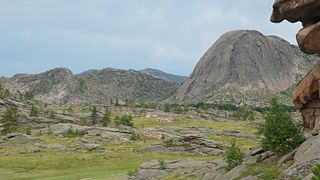
WAktogay Canyon is located in the Zhalanash valley on the territory of Enbekshikazakh district of Almaty region. The Aktogay canyon is a continuation of the Charyn canyon. The canyon has a trapezoidal shape. The canyon reaches three kilometers wide and 200 to 300 meters deep. The canyon's name means "white stream" in translation from the Kazakh language. It is part of the Charyn National Park and is located within the territory of the Uygur District, Raiymbek District and Enbekshikazakh District.
 W
WAltyn-Emel National Park is a national park in Kazakhstan. It was created in 1996. The park covers about 4,600 km2 (1,800 sq mi) between the Ili River and the Ak-Tau mountain range, near Lake Kapchagai, and consists mostly of desert and rocky terrain.
 W
WBayanaul National Park is a national park of Kazakhstan, located in southeastern Pavlodar Province, 140 kilometers from the industrially developed city of Ekibastuz, on the outskirts of the Central Kazakh Uplands. It is included on the list of protected areas of Kazakhstan. The park was founded in 1985, making it Kazakhstan's first national park. It was created to preserve and restore the natural flora and fauna found in the Bayanaul mountain range. The park's total area is 68,453 hectares.
 W
WBuiratau National Park or Buyratau National Nature Park was created in 2011 to preserve a unique transitional zone between dry steppe and semi-arid forest ecosystems of the Central Uplands of Kazakhstan. The park straddles the border of Ereymentau District of Akmola Region, and Osakarov District of Karaganda Region, and is about 60 km east of the capital city of Astana.
 W
WThe Burabay National Park is a natural park located in the Burabay District, in Aqmola Region, Kazakhstan.
 W
WCharyn Canyon is a canyon on the Sharyn River in Kazakhstan. The canyon is roughly 90 kilometres (56 mi) in length. It is part of the Charyn National Park, and is located within the territory of the Uygur District, Raiymbek District and Enbekshikazakh District. Over time, the canyon has gained colorful formations of varying shapes and sizes. Though it is much smaller than the Grand Canyon, it has been described as being equally impressive.
 W
WCharyn National Park officially, Charyn Canyon National Nature Park is a national park in Kazakhstan, stretching along the Charyn River, including Charyn Canyon. The Canyon, with its thinly stratified red sedimentary rock, it is said to resemble the Grand Canyon in the US; it is however smaller - 50 km from end to end. About 125,050 hectares in size, the park occupies portions of Enbekshikazakh District, Raiymbek District, and Uygur District of Almaty Region. It is about 200 km east of the city of Almaty. The park was established in 2004 to protect the geological attractions of the canyon, the ecological fragility of the river and desert system, and surrounding archaeological sites; portions are also set aside for recreation.
 W
WIle-Alatau National Park is a national park in Kazakhstan. It was created in 1996 and covers about 200,000 ha. It is situated in the mountains south of Almaty between Gorge Turgen in the east and Chemolgan River in the west. The National Park borders Almaty Nature Reserve, which is located around Pik Talgar.
WKarkaraly National Park is a protected reserve and national park in the Karaganda Region of Kazakhstan. The park spans 90,323 hectares, and is located in Karkaraly District.
 W
WKaton-Karagay National Park is the largest national park in Kazakhstan, located on the eastern edge of the country, in the Southern Altai Mountains. The park fills the west side of the "X" where the borders of Kazakhstan, Russia, China, and Mongolia meet. The highest peak in Siberia, is on the Russian border in the Katun Range. The park is in Katonkaragay District of East Kazakhstan Region, 1,000 kilometres (620 mi) southeast of the capital city of Astana.
 W
WKokshetau National Park features the unique landscape, archaeological sites, and recreational opportunities of the Kazakh Uplands of Northern Kazakhstan. Located in the transition zone between the Siberian taiga and the southern steppes, the terrain is an "island" of forests, lakes, and mountains surrounded by steppe. Kokshetau is located in Zerendi District, Aqmola Region and Aiyrtau District, North Kazakhstan Region. The park boundary is 45 kilometres (28 mi) west of the city of Kokshetau itself, and 275 kilometres (171 mi) northwest of the capital city of Nur-Sultan.
 W
WKolsay Lakes National Park is located on the north slope of the Tian Shan Mountains, southeast Kazakhstan. Often referred to as "Pearls of Tien Shan", the park's main feature are the Kolsay Lakes located between the Raiymbek District and Talgar District of Almaty Region. The scenic Lake Kaindy is also within the park. The park boundary is 120 kilometres (75 mi) southeast of Almaty. Lakes of landslide-tectonic origin, approximately formed in 1887 and 1911 on the Kaindy and Kolsay rivers.
 W
WSayram-Ugam National Park, also Sairam-Ugam, is a mountainous region of the Western Tian Shan Mountains, on the border with Uzbekistan. Ugam-Chatkal National Park of Uzbekistan is across the border, and Aksu-Zhabagly Nature Reserve of Kazakhstan is directly to the northeast along the border. The area has high levels of species diversity, covering floral communities from steppe to high altitude zones. It is particularly known for stands of juniper forests, and stands of fruit and nut trees. Sayram-Ugam is located in Kazygurt District, Tole Bi District and Tulkibas District of South Kazakhstan Region. The park boundary is 30 kilometres (19 mi) southeast of the regional city of Shymkent, and 50 km northeast of the Uzbekh capital of Tashkent.
 W
WTarbagatai National Park, also Tarbagatay, was established in 2018 to protect a region of mountain-steppe in East Kazakhstan that supports stands of wild fruit trees that have been isolated from genetic encroachment by commercial varieties.
 W
WZhongar-Alatau National Park, also Jungar Alatau, or Dzungurian Alatau, was created in 2010 to protect the unique ecology of the Dzungarian Alatau, an isolated, glaciated mountain range in Kazakhstan, on the southeastern border with China. One stated reason for creating the park is to protect forests of wild fruit trees, including apricots, barberry, cherries, and currants. Approximately 1% of the land area of the park is forested with Sievers Apple trees, which are the progenitors of all cultured apple varieties in the world. The park is 300 km long (west-to-east), and spreads across Aksu District, Sarkand District and Alakol District of Almaty Region, 300 km northeast of the regional city of Almaty.