 W
WAvalon is a suburb of Lower Hutt in New Zealand, formed as a private residential development in the 1970s on land formerly occupied by market-gardens on the left (eastern) bank of the Hutt River. It features mostly California-inspired designed houses, often split-level, with 3 or 4 bedrooms.
 W
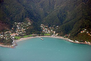
WDays Bay is a residential area in Lower Hutt in the Wellington Region of the North Island of New Zealand. It is walled on three sides by steep bush-clad slopes. Most of its level land is occupied by Williams Park and an independent boys' primary school, originally a part of Williams Park.
 W
WEastbourne is a prominent and well-to-do suburb of Lower Hutt, a part of Wellington, New Zealand. Lying languidly beside the sea, it is a popular local tourist destination via car from Petone or from ferry crossings from central Wellington. Eastbourne had a population of 4,665 people as of the 2013 New Zealand census. An outer suburb, it lies on the eastern shore of Wellington Harbour, five kilometres south of the main Lower Hutt urban area and directly across the harbour from the Miramar Peninsula in Wellington city. A narrow exposed coastal road connects it with the rest of Lower Hutt via the industrial suburb of Seaview. It is named for Eastbourne in England, another seaside town known for fanciness and day-trips.
 W
WHaywards is a small hillside suburb in the Hutt Valley near Wellington, New Zealand. It is notable for its large electrical substation, which is the main switching point for the Wellington region, and the home of the North Island converter station for the HVDC Inter-Island, which links the North and South Island electricity networks together.
WKelson is a suburb of Lower Hutt in Wellington, New Zealand. It is situated on the western hills of the Hutt Valley. To the west of the suburb lies the Belmont Regional Park, while to the east runs the Hutt River and State Highway 2.
 W
WKorokoro, a suburb of Lower Hutt City, lies in the south of the North Island of New Zealand. The suburb occupies part of the western hills of the Hutt Valley; its eastern slopes overlook Petone and the Wellington harbour.
WManor Park is the northernmost suburb of Lower Hutt City situated at the bottom of the North Island of New Zealand. The suburb is located on the western side of the Hutt River and State Highway 2.
WMelling is a suburb of Lower Hutt, to the north of Wellington in the North Island of New Zealand. It is on the west bank of the Hutt River, on State Highway 2, the Wellington-Hutt main road, and directly across the river from the centre of Lower Hutt. It is also the name of the three-lane bridge connecting the Hutt City central business district with State Highway 2, a route subject to extensive congestion at peak times. From the Melling Bridge it is possible to drive straight ahead into the hill suburbs of Harbour View and Tirohanga.
WNaenae is a suburb of the city of Lower Hutt, New Zealand. It lies on the eastern edge of the floodplain of the Hutt River, four kilometres from the Lower Hutt Central business district. A small tributary of the Hutt, the Waiwhetu Stream, flows through the suburb. Naenae has a population of around 8,000 people.
 W
WNormandale is a semi-rural suburb of Lower Hutt City, New Zealand, on the western hills of the Hutt Valley. It consists of two main roads – Normandale Road and Miromiro Road – and the hills between, and is a five-minute drive from the Lower Hutt city centre.
 W
WPetone, a large suburb of Lower Hutt in the Wellington Region of New Zealand's North Island, stands at the southern end of the Hutt Valley, on the northern shore of Wellington Harbour. The Māori name Pito-one means "end of the sand beach".
 W
WSeaview is an industrial suburb of Lower Hutt, itself a suburb of Wellington, the capital of New Zealand. Situated in the far east end of Wellington, it begins once Te Awa Kairangi / the Hutt River is crossed via Petone, curving south to the bays of Eastbourne. it is traditionally a very industrial suburb, an annex of the larger neighbouring Petone, but has undergone rejuvenation as the local car industry has died out. Known for boganesque motor racing, sultry weather, its former car industry and current revitalisation, the suburb has made a name for itself in Wellington in recent years.
 W
WStokes Valley, a major suburb of the city of Lower Hutt in the North Island of New Zealand, lies at the edge of the city, seven kilometres northeast of the city centre. It occupies the valley of a small tributary of the Hutt River, called Stokes Valley Stream, which flows north to meet the main river close to the Taitā Gorge. Stokes Valley takes its name from Robert Stokes, who formed part of the original survey team of 1840 commissioned to plan the city at Thorndon in Wellington.
 W
WWainuiomata is a large suburb of Lower Hutt, in the Wellington Region of New Zealand's North Island. At the 2013 census, Wainuiomata had a population of 16,786.
 W
WWaiwhetū is an eastern suburb of Lower Hutt in the Wellington Region situated in the south of the North Island of New Zealand.
 W
WWoburn is a suburb of Lower Hutt, Wellington situated at the bottom of the North Island of New Zealand.