 W
WAalo, formerly Along, is a census town and headquarter of the West Siang district of the Indian state of Arunachal Pradesh. It is located about a day's drive 220 kilometres (140 mi) from Likabali, which is at the border of Assam and Arunachal Pradesh.
 W
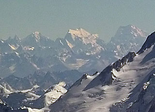
WThe Actual Ground Position Line (AGPL) divides current positions of Indian and Pakistani military posts and troops across the entire 110 kilometres (68 mi) long front line in the disputed region of Siachen Glacier. AGPL generally runs along the Saltoro Mountains range, beginning from the northernmost point of the (LOC) at Point NJ 9842 and ending in the north on the Indira Ridge at the India-China-Pakistan LAC tripoint a km southeast of Sia Kangri and 3 km southwest of Indira Col West, with peaks in excess of 7,000 meters and average temperature around minus 50 celsius. India gained control of 1,000 square miles (2,600 km2) of disputed territory in 1984 because of its military operations in Siachen. A cease-fire was announced in 2003.
 W
WDaporijo Airport is located at Daporijo in the state of Arunachal Pradesh, India. Daporijo used to have scheduled services in the 1980s and early 1990s from Vayudoot. The airport had flights to Guwahati and Dibrugarh on Dornier Do 228 aircraft. Currently, there is no scheduled commercial air service to the airport, although the airport is used by the Indian Army. The Airports Authority of India (AAI) plans to develop the airport for operation of ATR-42/ATR-72 type of aircraft.
 W
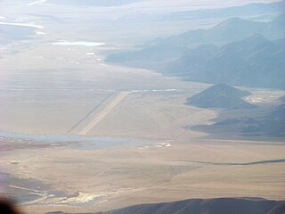
WDaulat Beg Oldi is a historic campsite and current military base located in Ladakh, India on an ancient trade route connecting Ladakh to the Tarim Basin. It is named after Sultan Said Khan, who died here on his return journey after the invasion of Ladakh and Kashmir. The Chip Chap River flows just to the south of Daulat Beg Oldi from east to west. Daulat Beg Oldi also has one of the world's highest airstrips which is one of India's Advance Landing Ground (ALG), at an altitude of 5,065 meters.
 W
WFukche Advanced Landing Ground is an airfield in the Demchok sector of the union territory of Ladakh, India. It was built shortly after the 1962 Sino-Indian War and was revived in 2008.
 W
WKibber also Kyibar is a village high in the Spiti Valley in the Himalayas at 4270 metres or 14,200 ft in Himachal Pradesh in northern India. It contains a monastery and the Kibber Wildlife Sanctuary. Kibber lies in a narrow valley on the summit of a limestone rock. It is located 20 kilometres from Kaza and a bus service connects them in the milder summer months. Agriculture forms the backbone of the local economy and lush green fields are abundant. Villagers count on the 3 day traditional trade route over Parang La to Ladakh to barter their horses for yaks or to sell for cash.
 W
WKullu–Manali Airport is an airport located in Bhuntar in the Indian state of Himachal Pradesh. The airport is located 11 km from Kullu and 52 km from Manali.
 W
WKushok Bakula Rimpochee Airport is an airport in Leh, the capital of Ladakh, India. It is the 23rd highest commercial airport in the world at 3,256 m (10,682 ft) above mean sea level. The airport is named after 19th Kushok Bakula Rinpoche, an Indian statesman and monk, whose Spituk Monastery is in direct vicinity to the airfield.
 W
WMechuka Advanced Landing Ground is an Indian Air Force airstrip located at Mechuka in Shi Yomi district of Arunachal Pradesh, India. It is an Advance Landing Ground (ALG) of Indian Air Force.
 W
WPakyong Airport is a greenfield RCS airport at Pakyong town near Gangtok, the state capital of Sikkim, India.
 W
WPasighat is the headquarters of East Siang district in the Indian state of Arunachal Pradesh. Situated at the eastern foothills of the Himalayas at 155 meters (509 ft) above mean sea level, Pasighat is Arunachal's oldest town. The Government of India included Pasighat in the Smart Cities Mission development scheme in June 2017.
 W
WSaltoro Kangri is the highest peak of the Saltoro Mountains subrange of Karakoram range, also known as the Saltoro Range, which is a part of the Karakoram. Saltoro Kangri is a name generally used for the twin peaks, the Saltoro Kangri I to the south and the Saltoro Kangri II, connected by a saddle. While comparing the heights the generic term Saltoro Kangri is applied to the higher peak, Saltoro Kangri I, which is the 31st highest mountain in the world in remote reaches of Karokaram. It is located on the Actual Ground Position Line between Indian controlled territory in the Siachen region and Pakistani controlled territory west of the Saltoro Range.
 W
WSiachen Base Camp, 12,000 feet above sea level at Partapur, is a base camp of 102 Infantry Brigade of XIV Corps of Indian Army which protects 110 km long Actual Ground Position Line (AGPL) with at least 108 forward military outposts and artillery observation posts in the disputed region of Siachen Glacier in Ladakh Union Territory of India. It is approximately 6 hours drive north from the town of Leh via the world's highest motorable pass Khardung La at 18,380 feet. Bana Top is the farthest and highest post which is 80 km away and takes up to 20 days trek for troops to reach, Pahalwan Post and Indira Col are other highest posts. Kumar Post or Kumar Base, which serves as the battalion head quarter, is named after the Colonel Narendra "Bull" Kumar and it is 60 km from the Siachen base towards Indira Col. The Siachen brigade consists of five to eight battalions of Ladakh Scouts supported by artillery, air defence, engineer and other logistic units. Pakistan has not been able to scale the crest of the Saltoro Range occupied by India. The temperature goes down to minus 86°C during winters with icy 300 kmph blizzards. The average temperature is between minus 25°C during day and minus 55°C during the night.
 W
WThoise or Thoise Airbase is a military airfield and small village in Nubra region of Ladakh, India, occupying the only large piece of flat land in the area. The airstrip is a critical facility enabling a quick inflow of men and material from the Indian interior to Siachen, a glacier, helipad and battleground near the Actual Ground Position Line between India and Pakistan.
 W
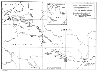
WThe China–Pakistan border is 592 kilometres (368 mi) and runs west-east from the disputed tripoint with Afghanistan to the disputed tripoint with India in the vicinity of the Siachen Glacier. It traverses the Karakorum Mountains, one of the world's tallest mountain ranges. Hunza District, Shigar District and Ghanche District in Gilgit-Baltistan administered by Pakistan border Taxkorgan Tajik Autonomous County and Kargilik/Yecheng County in Kashgar Prefecture, Xinjiang Uygur Autonomous Region, China.
 W
WThe India–Pakistan border, locally referred to as the International Border (IB), is an international border that runs between the states of Pakistan and India. The Line of Control (LoC), which separates the disputed territories of Indian-administered Kashmir and Pakistani-administered Kashmir, serves as the international border's de facto northern end, whereas the disputed territory of Sir Creek, located in the Rann of Kutch desert between the Indian state of Gujarat and the Pakistani province of Sindh, serves as the international border's de facto southern end. With the exception of Kashmir in the north and Sir Creek in the south, the border is mutually recognized and undisputed by both India and Pakistan.
 W
WThe Iran–Pakistan border is the international border between Iran and Pakistan, demarcating Pakistan's Balochistan province from Iran's Sistan and Balochistan Province; it is 959 kilometres in length. Since circa 2007 Iran has started constructing a border barrier as a replacement for an intermittent tattered border fence.