 W
WAn Earth observation satellite or Earth remote sensing satellite is a satellite used or designed for Earth observation (EO) from orbit, including spy satellites and similar ones intended for non-military uses such as environmental monitoring, meteorology, cartography and others. The most common type are Earth imaging satellites, that take satellite images, analogous to aerial photographs; some EO satellites may perform remote sensing without forming pictures, such as in GNSS radio occultation.
WThe A-train is a satellite constellation of four Earth observation satellites of varied nationality in sun-synchronous orbit at an altitude of 705 km (438 mi) above the Earth.
Constellation Observing System for Meteorology, Ionosphere, and Climate (COSMIC) is a program designed to provide advances in meteorology, ionospheric research, climatology, and space weather by using GPS satellites in conjunction with low Earth orbiting (LEO) satellites. The term "COSMIC" may refer to either the organization itself or the constellation of 6 satellites. The constellation is a joint U.S.-Taiwanese project with major participants including the University Corporation for Atmospheric Research (UCAR), the National Science Foundation, the Naval Research Laboratory (NRL), the Air Force Research Laboratory (AFRL), SRI International on the U.S. side and the National Space Organization (NSPO) on the Taiwanese side.
 W
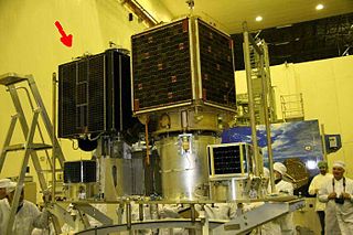
WDiwata-1 also known as PHL-Microsat-1 was a Philippine microsatellite launched to the International Space Station (ISS) on March 23, 2016, and was deployed into orbit from the ISS on April 27, 2016. It was the first Philippine microsatellite and the first satellite built and designed by Filipinos. It was followed by Diwata-2, launched in 2018.
 W
WEgyptSat 1 or MisrSat-1 was Egypt's first Earth remote sensing satellite. This satellite was jointly built by Egypt's National Authority for Remote Sensing and Space Sciences together with the Yuzhnoye Design Bureau in Ukraine and was launched on board a Dnepr rocket on 17 April 2007 from the Baikonur Cosmodrome.
 W
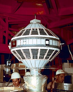
WExplorer 6, or S-2, was an American satellite launched on August 7, 1959. It was a small, spheroidal satellite designed to study trapped radiation of various energies, galactic cosmic rays, geomagnetism, radio propagation in the upper atmosphere, and the flux of micrometeorites. It also tested a scanning device designed for photographing the Earth's cloud cover, and transmitted the first pictures of Earth via satellite.
 W
WExplorer 7 was launched October 13, 1959 at 10:36 a.m. Eastern Time by a Juno II rocket from Cape Canaveral Air Force Station to an orbit of 573 km by 1073 km and inclination of 50.27°. It was designed to measure solar x-ray and Lyman-alpha flux, trapped energetic particles, and heavy primary cosmic rays. Secondary objectives included collecting data on micrometeoroid penetration, molecular sputtering and studying the Earth-atmosphere heat balance.
 W
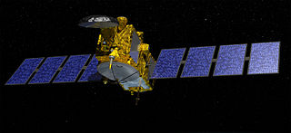
WJason-3 is a satellite altimeter created by a partnership of the European Organisation for the Exploitation of Meteorological Satellites (EUMETSAT) and National Aeronautic and Space Administration (NASA), and is an international cooperative mission in which National Oceanic and Atmospheric Administration (NOAA) is partnering with the Centre National d'Études Spatiales. The satellites' mission is to supply data for scientific, commercial, and practical applications to sea level rise, sea surface temperature, ocean temperature circulation, and climate change.
The Philippine Scientific Earth Observation Microsatellite (PHL-Microsat) program is a satellite program carried by the Department of Science and Technology (DOST) of the Philippines in cooperation with the Tohoku and Hokkaido Universities of Japan.
 W
WSAC-D, also known as Aquarius after its primary instrument, is an Argentine Earth science satellite built by INVAP and operated by CONAE. SAC-D was launched from Vandenberg Air Force Base on 10 June 2011, with a planned mission life of five years. Due to a power system failure, the mission was ended on 8 June 2015.
 W
WSatellite crop monitoring is the technology which facilitates real-time crop vegetation index monitoring via spectral analysis of high resolution satellite images for different fields and crops which enables to track positive and negative dynamics of crop development. The difference in vegetation index informs about single-crop development disproportions that speaks for the necessity of additional agriculture works on particular field zones—that is because satellite crop monitoring belongs to precision agriculture methods.
 W
WSatellite images are images of Earth collected by imaging satellites operated by governments and businesses around the world. Satellite imaging companies sell images by licensing them to governments and businesses such as Apple Maps and Google Maps. It should not be confused for astronomy images collected by space telescope.
 W
WSich-1 is the first Ukrainian Earth observation satellite and was launched on 31 August 1995 at 06:49:59 UTC by Ukrainian Tsyklon-3 rocket from Plesetsk Cosmodrome in Russia.
 W
WSpace-based radar is space-borne radar systems that may have any of a variety of purposes. A number of Earth-observing radar satellites, such as RADARSAT, have employed synthetic aperture radar (SAR) to obtain terrain and land-cover information about the Earth.
 W
WSTSAT-2C, or Science and Technology Satellite 2C, or Naro Science Satellite(ko:나로과학위성) was a South Korean satellite which was launched in 2013. It was operated by the Korea Aerospace Research Institute, and was intended to demonstrate technology for future spacecraft. The satellite had a mass of 100 kilograms (220 lb), and was expected to operate for less than a year.
 W
WTanDEM-X is the name of TerraSAR-X's twin satellite, a German Earth observation satellite using SAR - a modern radar imaging technology. Implemented in a Public-Private-Partnership between the German Aerospace centre (DLR) and EADS Astrium, it is a second, almost identical spacecraft to TerraSAR-X. TanDEM-X is also the name of the satellite mission flying the two satellites in a closely controlled formation with typical distances between 250 and 500 m. The twin satellite constellation allowed the generation of WorldDEM global digital elevation models starting in 2014.
 W
WTian Hui-1 is a Chinese earth observation satellite built by Dong Feng Hong, a China Aerospace Science and Technology Corporation (CASC). Tian Hui-1 was launched on 6 May 2012 at 9:10 UTC on a Long March 2 2D booster rocket into a sun-synchronous, polar orbit with an apogee of 490 km (300 mi) and perigee of 505 km (314 mi).